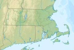
Cheshire is a town in Berkshire County, Massachusetts, United States. It is part of the Pittsfield, Massachusetts Metropolitan Statistical Area. The population was 3,258 at the 2020 census.

Clarksburg is a town in Berkshire County, Massachusetts, United States. It is part of the Pittsfield, Massachusetts Metropolitan Statistical Area. The population was 1,657 at the 2020 census.

Florida is a town in Berkshire County, Massachusetts, United States. It is part of the Pittsfield, Massachusetts Metropolitan Statistical Area. It is home to the east portal of the Hoosac Tunnel, as well as Whitcomb Summit, the highest point of the Mohawk Trail. Florida contains the village of Drury. At the 2020 census the town had a total population of 694. Despite the town’s name, Florida is statistically the coldest and snowiest town in Massachusetts.

Lanesborough is a town in Berkshire County, Massachusetts, United States. It is part of the Pittsfield, Massachusetts Metropolitan Statistical Area. The population was 3,038 at the 2020 census.

North Adams is a city in Berkshire County, Massachusetts, United States. It is part of the Pittsfield, Massachusetts Metropolitan Statistical Area. Its population was 12,961 as of the 2020 census. Best known as the home of the largest contemporary art museum in the United States, the Massachusetts Museum of Contemporary Art, North Adams has in recent years become a center for tourism, culture and recreation.
Savoy is a town in Berkshire County, Massachusetts, United States. It is part of the Pittsfield, Massachusetts Metropolitan Statistical Area. The population was 645 at the 2020 census.

Williamstown is a town in Berkshire County, Massachusetts, United States. It shares a border with Vermont to the north and New York to the west. Located in Berkshire County, the town is part of the Pittsfield, Massachusetts metropolitan statistical area. The population was 7,513 at the 2020 census. A college town, it is home to Williams College, the Clark Art Institute and the Tony-awarded Williamstown Theatre Festival.
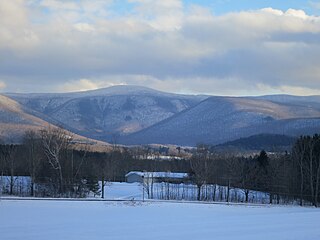
Mount Greylock in northwest Massachusetts is the highest point in the state at 3,489 feet. The peak played a role in early American literature, and is part of the Taconic Mountains, which are geologically distinct from the nearby Berkshires and Green Mountains. Expansive views and a small area of sub-alpine forest characterize its upper reaches. A seasonal automobile road crosses the summit area near three structures from the 1930s which together constitute a small, "National Historic District." Various hiking paths including the Appalachian Trail traverse the area, which is part of the larger Mount Greylock State Reservation.

Adams is a town in northern Berkshire County, Massachusetts, United States. It is part of the Pittsfield, Massachusetts Metropolitan Statistical Area. The population was 8,166 at the 2020 census.

The Hoosic River, also known as the Hoosac, the Hoosick and the Hoosuck, is a 76.3-mile-long (122.8 km) tributary of the Hudson River in the northeastern United States. The different spellings are the result of varying transliterations of the river's original Algonquian name. It can be translated either as "the beyond place" or as "the stony place".

The Hoosac Tunnel is a 4.75-mile (7.64 km) active railroad tunnel in western Massachusetts that passes through the Hoosac Range, an extension of Vermont's Green Mountains. It runs in a straight line from its east portal, along the Deerfield River in the town of Florida, to its west portal, in the city of North Adams.

The Boston and Albany Railroad was a railroad connecting Boston, Massachusetts to Albany, New York, later becoming part of the New York Central Railroad system, Conrail, and CSX Transportation. The line is currently used by CSX for freight. Passenger service is provided on the line by Amtrak, as part of their Lake Shore Limited service, and by the MBTA Commuter Rail system, which owns the section east of Worcester and operates it as its Framingham/Worcester Line.

The Fitchburg Railroad is a former railroad company, which built a railroad line across northern Massachusetts, United States, leading to and through the Hoosac Tunnel. The Fitchburg was leased to the Boston and Maine Railroad in 1900. The main line from Boston to Fitchburg is now operated as the MBTA Fitchburg Line; Pan Am Railways runs freight service on some other portions.

Route 8 is the portion of the 148 mile multistate New England Route 8 within the state of Massachusetts. The highway runs 66.643 miles (107.252 km) from the Connecticut state line in Sandisfield, where the highway continues as Connecticut Route 8, north to the Vermont state line in Clarksburg, where the highway continues as Vermont Route 8 and VT 100. Route 8 serves several towns in eastern and northern Berkshire County. The highway is the main highway between the cities of Pittsfield and North Adams, where the route intersects Route 9 and Route 2, respectively. Route 8 also intersects U.S. Route 20 in Becket.

The Cape Cod Rail Trail (CCRT) is a 25.5-mile (41.0 km) paved rail trail located on Cape Cod in Massachusetts. The trail route passes through the towns of Yarmouth, Dennis, Harwich, Brewster, Orleans, Eastham, and Wellfleet. It connects to the 6-plus mile (10 km) Old Colony Rail Trail leading to Chatham, the 2 mile Yarmouth multi-use trail, and 8 miles (13 km) of trails within Nickerson State Park. Short side trips on roads lead to national seashore beaches including Coast Guard Beach at the end of the Nauset Bike Trail in Cape Cod National Seashore. The trail is part of the Claire Saltonstall Bikeway.

The Norwottuck Branch Rail Trail, full name the Norwottuck Branch of the Mass Central Rail Trail, formerly the Norwottuck Rail Trail, is an 11-mile (18 km) combination bicycle/pedestrian paved rail trail running from Northampton, Massachusetts, through Hadley and Amherst, to Belchertown, Massachusetts. It opened in 1993, and is now part of the longer Mass Central Rail Trail.
Commonwealth Connections is a greenway and conservation initiative co-developed by the Commonwealth of Massachusetts Department of Conservation and Recreation (DCR), the National Park Service, and over fifty trail and land conservation agencies and non-profit organizations. Begun in 1999, the initiative was designed to create "a coordinated greenway and trail network that will help conserve important resources, provide recreation and alternative transportation opportunities close to where people live, and connect communities throughout Massachusetts."

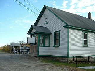
Adams is a former train station at 10 Pleasant Street in Adams, Massachusetts. Built in 1899, it served as the town's principal rail station on the North Adams Branch of the Boston and Albany Railroad until the mid-20th century. The surviving buildings were listed on the National Register of Historic Places in 1982 as the Pittsfield & North Adams Passenger Station and Baggage & Express House. The former station is currently the home of a sports bar and restaurant.

Western Gateway Heritage State Park is a history-focused Massachusetts state park in the city of North Adams managed by the Department of Conservation and Recreation. Exhibits at the park, which is located in a former railyard, tell the story of the creation of the Hoosac Tunnel. The freight yard was listed on the National Register of Historic Places in 1972 as the Freight Yard Historic District.

The Pittsfield and North Adams Railroad was a railroad based in northwestern Massachusetts. It was chartered in 1842 and was purchased by the Western Railroad of Massachusetts before construction was finished in 1846, then acquired by the Boston and Albany Railroad in 1870, only to face a gradual demise between the 1960s and 1990. It ran 18.539 mi (29.836 km) from North Adams Junction in Pittsfield to North Adams, where it connected to the Troy and Greenfield Railroad, an affiliate of the Fitchburg Railroad.