
Roxbury is a neighborhood within the City of Boston, Massachusetts.
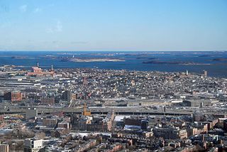
South Boston is a densely populated neighborhood of Boston, Massachusetts, located south and east of the Fort Point Channel and abutting Dorchester Bay. South Boston, colloquially known as Southie, has undergone several demographic transformations since being annexed to the city of Boston in 1804. The neighborhood, once primarily farmland, is popularly known by its twentieth century identity as a working class Irish Catholic community. Throughout the twenty-first century, the neighborhood has become increasingly popular with millennial professionals.

The Back Bay Fens, often called The Fens, is a parkland and urban wild in Boston, Massachusetts, in the United States. It was established in 1879. Designed by Frederick Law Olmsted to serve as a link in the Emerald Necklace park system, the Fens gives its name to the Fenway-Kenmore neighborhood.

The Freedom Trail is a 2.5-mile-long (4.0 km) path through Boston, Massachusetts, that passes by 16 locations significant to the history of the United States. Marked largely with brick, it winds from Boston Common in downtown Boston through the North End to the Bunker Hill Monument in Charlestown. Stops along the trail include simple explanatory ground markers, graveyards, notable churches and buildings, and a historic naval frigate. While most of the sites are free or suggest donations, the Old South Meeting House, the Old State House, and the Paul Revere House charge admission. The Freedom Trail is overseen by the City of Boston's Freedom Trail Commission and is supported in part by grants from various nonprofits and foundations, private philanthropy, and Boston National Historical Park.

Middlesex Fells Reservation, often referred to simply as the Fells, is a public recreation area covering more than 2,200 acres (890 ha) in Malden, Medford, Melrose, Stoneham, and Winchester, Massachusetts. The state park surrounds two inactive reservoirs, Spot Pond and the Fells Reservoir, and the three active reservoirs that are part of the water supply system for the town of Winchester. Spot Pond and the Fells Reservoir are part of the Wachusett water system, one of six primary water systems that feed metropolitan Boston's waterworks. The park is managed by the Massachusetts Department of Conservation and Recreation and is part of the Metropolitan Park System of Greater Boston.
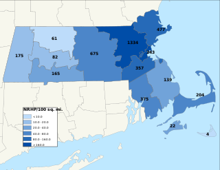
This is a list of properties and districts in Massachusetts listed on the National Register of Historic Places. There are over 4,300 listings in the state, representing about 5% of all NRHP listings nationwide and the second-most of any U.S. state, behind only New York. Listings appear in all 14 Massachusetts counties.

Byron Rushing represented the Ninth Suffolk district in the Massachusetts House of Representatives from 1983 to 2019. He represented the South End neighborhood of Boston. A Democrat, he was first elected in 1982, before losing his 2018 bid for reelection to Jon Santiago in the Democratic primary.
Frank Chouteau Brown (1876–1947) was an American architect, born in Minneapolis, Minnesota, and educated at the Minneapolis School of Fine Arts, the Boston Art Club and in Europe. In 1902, he began practice in Boston and from 1907 to 1919, was editor of the Architectural Review periodical. In 1916, he became a member of the faculty of Boston University and in 1919, head of the Department of Art and Architecture.

The Shirley–Eustis House is a historic house located at 33 Shirley Street, Boston, Massachusetts. It is a U.S. National Historic Landmark.
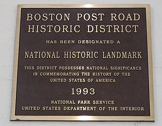
The Boston Post Road Historic District is a 286-acre (116 ha) National Historic Landmark District in Rye, New York, and is composed of five distinct and adjacent properties. Within this landmarked area are three architecturally significant, pre-Civil War mansions and their grounds; a 10,000-year-old Indigenous peoples site and viewshed; a private cemetery, and a nature preserve. It is one of only 11 National Historic Landmark Districts in New York State and the only National Historic Landmark District in Westchester County. It touches on the south side of the nation's oldest road, the Boston Post Road, which extends through Rye. A sandstone Westchester Turnpike marker "24", inspired by Benjamin Franklin's original mile marker system, is set into a wall that denotes the perimeter of three of the contributing properties. The district reaches to Milton Harbor of Long Island Sound. Two of the properties included in the National Park designation are anchored by Greek Revival buildings; the third property is dominated by a Gothic Revival structure that was designed by Alexander Jackson Davis.

The Muddy River is a series of brooks and ponds that runs through sections of Boston's Emerald Necklace, including along the south boundary of Brookline, Massachusetts. The river, which is narrower than most waterways designated as rivers in the United States, is a protected public recreation area surrounded by parks and hiking trails, managed by the Massachusetts Department of Conservation and Recreation.
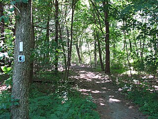
The Bay Circuit Trail and Greenway or Bay Circuit is a Massachusetts rail trail and greenway connecting the outlying suburbs of Boston from Plum Island in Newburyport to Kingston Bay in Duxbury, a distance of 200 miles (320 km).

The Dillaway School is an historic school at 16-20 Kenilworth Street in Boston, Massachusetts. The school was built in 1882 to a design by George Albert Clough, the city's first official architect, and is his only surviving school design in the city. The building was listed on the National Register of Historic Places in 1980, and included in the Roxbury Highlands Historic District in 1989. The building has been converted to residential use.

John Eliot Square District is a historic district located in the northern Roxbury neighborhood of Boston, Massachusetts. It is formed by the intersection of Dudley, Bartlett, Centre, Roxbury and Highland Streets. Named after local missionary to the Indians, John Eliot, the square was the site of the Roxbury town center after its founding in 1630. Roxbury was annexed to Boston in 1868, and John Eliot Square was added to the National Register of Historic Places in 1973. The square is the nucleus of Roxbury Heritage State Park, a history-themed heritage park.
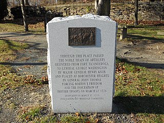
The Henry Knox Trail, also known as the Knox Cannon Trail, is a network of roads and paths that traces the route of Colonel Henry Knox's "noble train of artillery" from Crown Point to the Continental Army camp outside Boston, Massachusetts early in the American Revolutionary War.

The noble train of artillery, also known as the Knox Expedition, was an expedition led by Continental Army Colonel Henry Knox to transport heavy weaponry that had been captured at Fort Ticonderoga to the Continental Army camps outside Boston during the winter of 1775–76.

Southwest Corridor Park is a linear urban park in Boston, Massachusetts, part of the Metropolitan Park System of Greater Boston and managed by the Massachusetts Department of Conservation and Recreation (DCR). It extends from the South End and Back Bay neighborhoods south for almost five miles (8 km), ending in the Forest Hills section of Jamaica Plain in what was originally planned to be the alignment for Interstate 95 to Boston. It closely follows the routes of regional Amtrak and Commuter Rail lines and the Massachusetts Bay Transportation Authority (MBTA) Orange Line rapid transit rail line, from its Back Bay Station to its terminus at Forest Hills station. It features tennis courts, basketball courts, playgrounds, and walking, jogging, and biking paths.

Muriel Sutherland Snowden was the founder and co-director of Freedom House, a community improvement center in Roxbury, Massachusetts. She is, together with her husband Otto P. Snowden, a major figure in Boston history and activism.

Stony Brook is a 8.5-mile (13.7 km)-long subterranean river in Boston. The largest tributary stream of the lower Charles River, it runs mostly through conduits. Stony Brook originates at Turtle Pond in the Stony Brook Reservation and flows through Hyde Park, Roslindale, Jamaica Plain, and Roxbury. It empties into the Charles River Basin just upstream of the Harvard Bridge. Stony Brook is fed by four tributaries, all of which are partially or entirely in conduits as well.
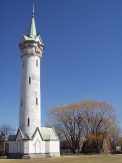
Fort Hill is a 0.4 square mile neighborhood and historic district of Roxbury, in Boston, Massachusetts. The approximate boundaries of Fort Hill are Malcolm X Boulevard on the north, Washington Street on the southeast, and Columbus Avenue on the southwest.


