
The Trustees of Reservations is a non-profit land conservation and historic preservation organization dedicated to preserving natural and historical places in the Commonwealth of Massachusetts. It is the oldest land conservation nonprofit organization of its kind in the world and has 140,000 dues-paying members as of 2018. In addition to land stewardship, the organization is also active in conservation partnerships, community supported agriculture (CSA), environmental and conservation education, community preservation and development, and green building. The Trustees of Reservations own title to 120 properties on 27,000 acres (11,000 ha) in Massachusetts, all of which are open to the public; it maintains conservation restrictions on over 200 additional properties. Properties include historic mansions, estates, and gardens; woodland preserves; waterfalls; mountain peaks; wetlands and riverways; coastal bluffs, beaches, and barrier islands; farmland and CSA projects; and archaeological sites.

Bear Swamp is a forested parkland in Ashfield, Massachusetts. The Trustees of Reservations owns and maintains the property.

The Charles W. Ward Reservation is a 704-acre (285 ha) open space reserve located in Andover and North Andover, Massachusetts, 20 miles (32 km) north of Boston. The reserve, managed by the land conservation non-profit organization The Trustees of Reservations, is notable for its open drumlin hilltops and vistas encompassing Boston and Salem. The Ward Reservation offers 13 miles (21 km) of trails and former woods roads available for hiking, horseback riding, mountain biking, and cross country skiing; it is also a link in the 200-mile (320 km) Bay Circuit Trail system.

Chapel Brook of Franklin County, Massachusetts is a tributary of the South River and the name of a 173-acre (70 ha) open space preserve located along the brook. The brook, est. 3.79 mi (6 km) long, is located in southeast Ashfield and southwest Conway. It drains into Poland Brook, thence into the South River, the Deerfield River, the Connecticut River, and Long Island Sound. The Chapel Brook reservation, managed by the non-profit conservation organization The Trustees of Reservations, is located in Ashfield and contains Chapel Falls, a series of three waterfalls on Chapel Brook, measuring 10 feet, 15 feet and 20 feet high; and Pony Mountain est. 1,400 feet, a 100-foot (30 m) open granite cliff face and popular recreational rock climbing site.

The Brooks Woodland Preserve is a 558-acre (226 ha) open space preserve located in Petersham, Massachusetts. The property, named after industrialist and diplomat James Wilson Brooks, is managed by the land conservation non-profit organization The Trustees of Reservations and offers 13 miles (21 km) of trails and primitive woods roads available for hiking, horseback riding, and cross country skiing. Second growth forest, overgrown farm fields, granite ledges, historic stone walls, creeks, and rolling hills characterize the preserve.

Peters Reservation is a nature reserve located in Dover, Massachusetts. The property is owned by The Trustees of Reservations; the reservation's first parcels were received as a gift in 1988. The reservation is located across Farm Street from the Chase Woodlands, another Trustees-managed property. The Charles River Link Trail crosses both reservations.
Tyringham Cobble is a 206-acre (83 ha) open space reservation located in Tyringham, Massachusetts on 411 m (1,348 ft) Cobble Hill in The Berkshires. It is managed by The Trustees of Reservations, a non-profit conservation organization, and is notable for its scenic views over the rural landscape of Tyringham Valley from rocky ledges and open fields. The reservation consists of the hill and surrounding agricultural and pasture land. In 2008, part of the 2,175 mile (3,500 km) Appalachian Trail was routed over the summit ledges.
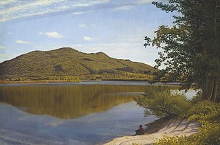
The Mount Tom Range is a traprock mountain range located in the Connecticut River Valley of Massachusetts. It is part of the Metacomet Ridge that extends from Long Island Sound near New Haven, Connecticut, north through the Connecticut River Valley of Massachusetts to nearly the Vermont border. A popular outdoor recreation resource, the range is known for its continuous west facing cliffs and its rugged, scenic character. It is also notable for its unique microclimate ecosystems and rare plant communities, as well as significant historic sites, such as the ruins of the 18th century Eyrie House located on Mount Nonotuck.

Royalston Falls is a 50 foot (15 m) waterfall and granite gorge located in Royalston, Massachusetts along Falls Brook, a tributary of the Tully River which in turn is a tributary of the Millers River. The falls are part of a 217-acre (88 ha) open space preserve acquired in 1951 by the land conservation non-profit organization The Trustees of Reservations. The 22-mile (35 km) Tully Trail and the 110-mile (180 km) Metacomet-Monadnock Trail, a National Recreation Trail, pass through the property.

Elliott Laurel is a 33-acre (13 ha) open space preserve located in Phillipston, Massachusetts. The property, notable for its extensive stands of mountain laurel, is managed by the land conservation non-profit organization The Trustees of Reservations. Elliott Laurel also contains woodlands, ledges, boulders, and a hayfield.
Jacobs Hill is a 173-acre (70 ha) open space preserve in Royalston, Massachusetts acquired in 1975 by the land conservation non-profit organization The Trustees of Reservations. The preserve includes scenic vistas, ledges, woodlands, a northern bog, and Spirit Falls, a 30 foot (9.1 m) waterfall. The 22-mile (35 km) Tully Trail passes through the property. Views from the ledges include the Berkshires as well as nearby Long Pond and the Tully River Valley, Tully Mountain, and Mount Grace.
Little Tom Mountain is a 73-acre (300,000 m2) nature preserve in Holyoke, Massachusetts and is managed by the Trustees of Reservations. The land was purchased in 2002 by a joint effort of the Trustees of Reservations, U.S. Fish and Wildlife Service, the Department of Conservation and Recreation, and the Holyoke Boys & Girls Club from the holders of the former Mt. Tom Ski area. The Trustees and the Holyoke Boys and Girls Club have a cooperative management approach of the area and run an environmental education program together.

The Rock House Reservation is a 196-acre (79 ha) open space preserve located in West Brookfield, Massachusetts. The property, acquired in 1993 by the land conservation non-profit organization The Trustees of Reservations, is named for a natural rock shelter once used as a winter camp by Native Americans. Its location near two, long Native American footpaths suggests that it may also have been a trail camp and meeting place.

Quinebaug Woods is a 36-acre (15 ha) open space preserve located in Holland, Massachusetts. The property, acquired in 2001 by the land conservation non-profit organization The Trustees of Reservations, is named for the Quinebaug River, which runs through the reservation.

North Common Meadow is a 25-acre (10 ha) open space preserve in the town of Petersham, Massachusetts. The property, part of a larger, contiguous area of protected open space including Harvard Forest and The Trustees of Reservations' Brooks Woodland Preserve, is maintained as grassland in keeping with the town's rural character.

Harvard Forest is an ecological research area of 3,000 acres (12 km2) owned and managed by Harvard University and located in Petersham, Massachusetts. The property, in operation since 1907, includes one of North America's oldest managed forests, educational and research facilities, a museum, and recreation trails. Harvard Forest is open to the public.

Moose Hill Farm is a 347-acre (140 ha) open space preserve and historic farm complex located in Sharon, Massachusetts near the 450 feet (140 m) summit of Moose Hill. The property, acquired in 2005 by the land conservation non-profit organization The Trustees of Reservations, includes farmland, woodlots, 21 farm buildings, hiking trails, stands of mature American Chestnuts, and scenic vistas of the Boston skyline. Moose Hill Farm is part of a larger area of protected open space including state land and the Massachusetts Audubon Society's Moose Hill Wildlife Sanctuary.

Cedariver, formerly known as The Baker Reservation, is a 55-acre (22 ha) open space preserve located on the Charles River in Millis, Massachusetts. The property, acquired in 2004 by the land conservation non-profit organization The Trustees of Reservations, includes farm fields, woodlots, and 1-mile (1.6 km) of river frontage.
Noon Hill is a 204-acre (83 ha) open space preserve located in Medfield, Massachusetts and centered on 370-foot (110 m) Noon Hill, a prominent summit and scenic vista. It is managed by the land conservation non-profit organization The Trustees of Reservations and offers 4.5 miles (7.2 km) of trails available for hiking, horseback riding, mountain biking, and cross country skiing. Oak-hickory forest, wetlands, vernal pools, steep ravines, boulders, and rocky ledges characterize the preserve. Noon Hill is a link in the 200-mile (320 km) Bay Circuit Trail. Holt Pond, a constructed mill pond, is located on the property.

Rocky Woods is a 491-acre (199 ha) open space preserve located in Medfield, Massachusetts. The preserve, managed by the land conservation non-profit organization The Trustees of Reservations, is notable for its rugged terrain. Rocky Woods offers 6.5 miles (10.5 km) of trails and former woods roads available for hiking, horseback riding, mountain biking, dog walking, catch and release fishing, camping, snowshoeing and cross country skiing. The preserve is part of a larger area of protected open space including the abutting Fork Factory Brook preserve, also managed by The Trustees of Reservations.
