
The Department of Conservation and Recreation (DCR) is a state agency of the Commonwealth of Massachusetts, United States, situated in the Executive Office of Energy and Environmental Affairs. It is best known for its parks and parkways. The DCR's mission is "To protect, promote and enhance our common wealth of natural, cultural and recreational resources for the well-being of all." The agency is the largest landowner in Massachusetts.
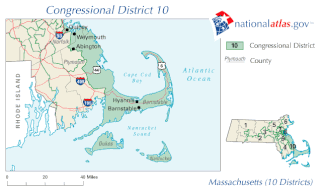
Massachusetts's 10th congressional district is an obsolete district that was active during 1795–2013. It was first located in the District of Maine during 1795–1803, then located in several different areas of Massachusetts. It was most recently eliminated in 2013 as district lines were redrawn to accommodate the loss of the seat due to reapportionment as a result of the 2010 census.

Mount Washington State Forest is a 4,619-acre (1,869 ha) state forest in Mount Washington, Massachusetts. The forest conjoins with New York state and the state of Connecticut in the southern Taconic Mountains of the southwestern Berkshire region of Massachusetts. In addition to offering recreational and scenic opportunities, the forest lies adjacent to Bash Bish Falls State Park. It is managed by the Massachusetts Department of Conservation and Recreation.

The Freetown-Fall River State Forest is a publicly owned forest covering more than 5,000 acres (2,000 ha) in the city of Fall River and the towns of Freetown and Lakeville in the state of Massachusetts. The forest lies mostly in the center of the town of Freetown dividing Assonet, East Freetown, and Fall River's northernmost boundary. The forest land includes Profile Rock, a granite outcropping which local Native Americans believe to be the image of Chief Massasoit, and a 227-acre (92 ha) Wampanoag reservation. The forest is owned by the Commonwealth of Massachusetts and operated by the Department of Conservation and Recreation with headquarters in Assonet.

Dighton Rock State Park is a public recreation area and historic preserve located on the eastern shore of the Taunton River in the town of Berkley, Massachusetts. The 98-acre (40 ha) state park is the site of a small museum that houses the Dighton Rock, an 11-foot-high (3.4 m) glacial erratic, covered with petroglyphs, that once sat on the banks of the river. It is managed by the Massachusetts Department of Conservation and Recreation.

Douglas State Forest is a publicly owned forest with recreational features located in the town of Douglas, Massachusetts, bordering both Connecticut and Rhode Island. The state forest's 5,525 acres (2,236 ha) include Wallum Lake and a rare Atlantic white cedar swamp, 5 acres (2.0 ha) of which are designated as a Massachusetts Wildland. The forest is managed by the Massachusetts Department of Conservation and Recreation.

Ashland State Park is a public recreation area surrounding the 157-acre (64 ha) Ashland Reservoir in the town of Ashland, Massachusetts. The state park's 470 acres (190 ha) incorporate the entire shoreline of the reservoir, which is abutted by the Warren Conference Center and Inn of Framingham State University, town-owned land once the site of Camp Winnetaska, and residential houses. The park is managed by the Massachusetts Department of Conservation and Recreation.

Brimfield State Forest is a Massachusetts state forest located in and around the town of Brimfield in Hampden County, Massachusetts. The forest includes Dean Pond Recreation Area, a popular spot for fishing, picnicking and swimming. The park is managed by the Department of Conservation and Recreation.

Mount Everett State Reservation is a public recreation area in the towns of Mount Washington and Sheffield, Massachusetts, that offers panoramic views of Massachusetts, Connecticut, and New York from the summit of 2,624-foot (800 m) Mount Everett. The reservation abuts Jug End State Reservation and Wildlife Management Area; Bash Bish Falls State Park and Mount Washington State Forest lie to the west. All are managed by the Massachusetts Department of Conservation and Recreation.
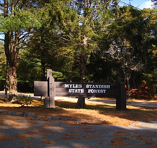
Myles Standish State Forest is a state forest located in the towns of Plymouth and Carver in southeastern Massachusetts, approximately 45 miles (70 km) south of Boston. It is the largest publicly owned recreation area in this part of Massachusetts and is managed by the Department of Conservation and Recreation (DCR).

Mount Race, 2,365 feet (721 m), is a mountain in Berkshire County, Massachusetts. It shares many characteristics with the slightly higher Mount Everett about a mile to the north. Part of the Taconic Mountains, Race is known for its waterfalls, an eastern escarpment of nearly 2,000 feet, and expansive views. The Appalachian Trail crosses its summit, which has an open forest of dwarf pitch pine and scrub oak.
The Taconic Skyline Trail is a 12.1 mi (19.5 km) multi-use trail in the Taconic Mountains of Berkshire County, Massachusetts. The trail extends from U.S. Route 20 in Hancock, Massachusetts, less than 1 mi (1.6 km) east of the New York border, north along the ridgecrest of the Taconic Range within Pittsfield State Forest and officially ending at Brodie Mountain Road on the Hancock/ Lanesborough town line.

Spencer State Forest is a Massachusetts state forest and recreation reserve located in the town of Spencer, managed by the Massachusetts Department of Conservation and Recreation. The 92 mile (148 km) Midstate Trail passes through the state forest. The Commonwealth of Massachusetts also conducts logging in some parts of the property.

F. Gilbert Hills State Forest is a 1,027-acre (416 ha), pine and oak Massachusetts state forest located in the towns of Foxborough and Wrentham. The forest, which is managed by the Massachusetts Department of Conservation and Recreation (DCR), was named for a former State Forester and employee.

Harold Parker State Forest is a publicly owned forest with recreational features encompassing more than 3,300 acres (1,300 ha) in the towns of Andover, North Andover, North Reading, and Middleton, Massachusetts. Ponds, swamps, rolling hills, glacial erratics and rocky outcroppings can be found in the state forest, which features more than 35 miles (56 km) of backwoods roads and trails as well as remnants of 18th-century farming and milling operations. It is managed by the Massachusetts Department of Conservation and Recreation.

Jug End State Reservation and Wildlife Management Area is a public recreation area located in the towns of Egremont and Mount Washington, Massachusetts. The reservation occupies the site of the former Jug End Barn resort, which has been allowed to return to a natural state. Mount Everett State Reservation is adjacent to the south. It is managed by the Department of Conservation and Recreation.

Windsor State Forest is a state forest in the town of Windsor in northwest Massachusetts. Managed by the Massachusetts Department of Conservation and Recreation, the forest is noted for the Windsor Jambs waterfall, which cascades through a 25-foot-wide (7.6 m) gorge between 80-foot-high (24 m) granite walls. Trails are available for hiking, mountain biking, horseback riding, and cross-country skiing. The park's former camping and swimming areas are currently closed but its day use area is slated to reopen in the spring of 2021.

Upton State Forest is a publicly owned forest with recreational features primarily located in the town of Upton, Massachusetts, with smaller sections in the towns of Hopkinton and Westborough. The state forest encompasses nearly 2,800 acres (1,100 ha) of publicly accessible lands and includes the last remaining Civilian Conservation Corps (CCC) camp in Massachusetts, built in Rustic style. The CCC campground was listed on the National Register of Historic Places in 2014.

