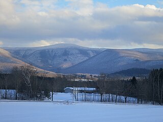
Mount Greylock is a 3,489-foot (1,063-meter) mountain located in the northwest corner of Massachusetts and is the highest point in the state. Its summit is in the western part of the town of Adams in Berkshire County. Technically, Mount Greylock is geologically part of the Taconic Mountains, which are not associated with the abutting Berkshire Mountains to the east. The mountain is known for its expansive views encompassing five states and the only taiga-boreal forest in the state. A seasonal automobile road climbs to the summit, topped by a 93-foot-high (28 m) lighthouse-like Massachusetts Veterans War Memorial Tower. A network of hiking trails traverses the mountain, including the Appalachian Trail. Mount Greylock State Reservation was created in 1898 as Massachusetts' first public land for the purpose of forest preservation.

Mount Greylock State Reservation is public recreation and nature preservation area on and around Mount Greylock, the highest point in the U.S. state of Massachusetts. The park covers some 12,000 acres (4,900 ha) in the towns of Lanesborough, North Adams, Adams, Cheshire, Williamstown and New Ashford, Massachusetts. It was created in 1898 as Massachusetts' first public land for the purpose of forest preservation.

Mount Washington State Forest is a 4,619-acre (1,869 ha) state forest in the Mount Washington, Massachusetts. The forest conjoins with New York state and the state of Connecticut in the southern Taconic Mountains of the southwestern Berkshire region of Massachusetts. In addition to offering recreational and scenic opportunities, the forest lies adajacent to Bash Bish Falls State Park. It is managed by the Massachusetts Department of Conservation and Recreation.

Dighton Rock State Park is a public recreation area and historic preserve located on the eastern shore of the Taunton River in the town of Berkley, Massachusetts. The 98-acre (40 ha) state park is the site of a small museum that houses the Dighton Rock, an 11-foot-high (3.4 m) glacial erratic, covered with petroglyphs, that once sat on the banks of the river. It is managed by the Massachusetts Department of Conservation and Recreation.

Brimfield State Forest is a Massachusetts state forest located in and around the town of Brimfield in Hampden County, Massachusetts. The forest includes Dean Pond Recreation Area, a popular spot for fishing, picnicking and swimming. The park is managed by the Department of Conservation and Recreation.

Mount Everett State Reservation is a public recreation area in the towns of Mount Washington and Sheffield, Massachusetts, that offers panoramic views of Massachusetts, Connecticut, and New York from the summit of 2,624-foot (800 m) Mount Everett. The reservation abuts Jug End State Reservation and Wildlife Management Area; Bash Bish Falls State Park and Mount Washington State Forest lie to the west. All are managed by the Massachusetts Department of Conservation and Recreation.

Mount Grace State Forest is a publicly owned forest with recreational features located in the town of Warwick. The state forest centers around Mount Grace, which at 1,621 feet (494 m) is the third highest point in Massachusetts east of the Connecticut River after Mount Wachusett and Mount Watatic. It is bordered by portions of Warwick State Forest to the east and west and is managed by the Massachusetts Department of Conservation and Recreation.
Sandisfield State Forest is a Massachusetts state forest filled with rolling hardwood forests in the town of Sandisfield. It is managed by the Department of Conservation and Recreation. A highlight of the forest is York Lake, which was created from swampy ground by the Civilian Conservation Corps in 1935.

Savoy, Mountain State Forest is a Massachusetts state forest located primarily in the towns of Savoy and Florida, with portions extending into neighboring Adams and North Adams. Situated along the Hoosac Mountain Range, it features four ponds, and seven hill and mountain summits, including Lewis Hill (2177 ft), Flat Rock Hill (2195 ft), Spruce Hill (2566 ft), and Borden Mountain (2505 ft). Also within the forest are at least two notable waterfalls, Parker Brook Falls and Tannery Falls, the latter of which is a 100-foot (30 m) drop. The forest is managed by the Department of Conservation and Recreation.
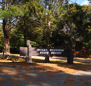
Myles Standish State Forest is a state forest located in the towns of Plymouth and Carver in southeastern Massachusetts, approximately 45 miles (70 km) south of Boston. It is the largest publicly owned recreation area in this part of Massachusetts and is managed by the Department of Conservation and Recreation (DCR).

October Mountain State Forest is a 16,460-acre (6,660 ha) forest and recreational preserve located primarily in the town of Washington with adjoining parcels in Becket, Lee, and Lenox. It is the largest state forest in Massachusetts and is managed by the Massachusetts Department of Conservation and Recreation.
Robinson State Park is a state-owned, public recreation area located mostly in the town of Agawam with a small section in Westfield, Massachusetts. The narrow, 1,025-acre (415 ha) state park follows the course of the meandering Westfield River which forms the park's northern border. The park is managed by the Massachusetts Department of Conservation and Recreation.

Nickerson State Park is a state-owned, public recreation area of more than 1,900 acres (770 ha) located on Cape Cod in Brewster, Massachusetts. The park's sandy soil and scrub pines surround many kettle ponds which are dependent on groundwater and precipitation. The largest of these are Cliff Pond, Flax Pond, Little Cliff Pond, and Higgins Pond. Ruth Pond, Keeler's Pond, Eel Pond, and Triangle Pond provide additional water habitats.

Squantum Point Park is a state-owned, public recreation area located on the Squantum peninsula of Quincy, Massachusetts, United States. The park was created on the site of the former Squantum Naval Air Station, which is preserved in a 2,700-foot-long (820 m) strip of runway, and the former dockworks of the Bethlehem Shipbuilding Corporation. The park is managed by the Massachusetts Department of Conservation and Recreation and is associated with the development of the Neponset River Reservation.

Spencer State Forest is a Massachusetts state forest and recreation reserve located in the town of Spencer, managed by the Massachusetts Department of Conservation and Recreation. The 92 mile (148 km) Midstate Trail passes through the state forest. The Commonwealth of Massachusetts also conducts logging in some parts of the property.

Scusset Beach State Reservation is a state-operated, public recreation area located in the town of Sandwich in Barnstable County, Massachusetts, at the east end of the Cape Cod Canal on land formerly part of Sagamore Hill Military Reservation. In addition to its beach and campgrounds, prominent features of the park include Sagamore Hill, a one-time Native American meeting ground and site of World War II coastal fortifications, and a 3,000-foot (910 m) stone jetty that separates the canal and beach. Unlike most of Sandwich, this section of the town is on the mainland side of the Cape Cod Canal. The state park is managed by the Massachusetts Department of Conservation and Recreation under a lease agreement with the U.S. Army Corps of Engineers.

Otter River State Forest is a publicly owned forest and recreational preserve located in the towns of Templeton, Winchendon, and Royalston in Massachusetts managed by the Massachusetts Department of Conservation and Recreation. The state forest encompasses the land surrounding the junction of the Otter and Millers rivers. Habitats include freshwater marsh, northern hardwood stands, and pine groves planted by the Civilian Conservation Corps to reforest former farmlands.
Kenneth Dubuque Memorial State Forest is a Massachusetts state forest in the northern Berkshire Hills in the towns of Hawley, Plainfield, and Savoy. The forest is managed by the Department of Conservation and Recreation (DCR). In 1985, the forest was named in memory of Kenneth M. Dubuque, a former employee of the Department of Environmental Management.
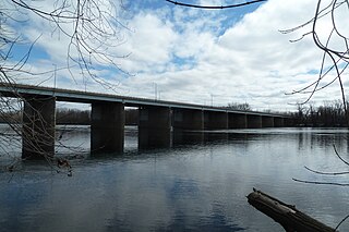
Windsor Meadows State Park is a public recreation area on the west side of the Connecticut River in the town of Windsor, Connecticut. The state park occupies three largely undeveloped sections measuring 48, 19, and 88 acres located between railroad tracks and the river. Park activities include picnicking, fishing, boating, hiking, and biking.
Mount Ascutney State Park is a state park in the U.S. state of Vermont. The park entrance is located along Vermont Route 44-A near the town of Windsor in Windsor County. Operated by the Vermont Department of Forests, Parks and Recreation, a significant portion of the park is listed on the National Register of Historic Places.


