
The Department of Conservation and Recreation (DCR) is a state agency of the Commonwealth of Massachusetts, United States, situated in the Executive Office of Energy and Environmental Affairs. It is best known for its parks and parkways. The DCR's mission is "To protect, promote and enhance our common wealth of natural, cultural and recreational resources for the well-being of all." The agency is the largest landowner in Massachusetts.

Middlesex Fells Reservation, often referred to simply as the Fells, is a public recreation area covering more than 2,200 acres (890 ha) in Malden, Medford, Melrose, Stoneham, and Winchester, Massachusetts, United States. The state park surrounds two inactive reservoirs, Spot Pond and the Fells Reservoir, and the three active reservoirs that are part of the water supply system for the town of Winchester. Spot Pond and the Fells Reservoir are part of the Wachusett water system, one of six primary water systems that feed metropolitan Boston's waterworks. The park is managed by the Massachusetts Department of Conservation and Recreation and is part of the Metropolitan Park System of Greater Boston.

Bash Bish Falls State Park is a Massachusetts state park located in the town of Mount Washington. The park is named after Bash Bish Falls, Massachusetts' highest single-drop waterfall, which lies within its borders. The park is managed by the Department of Conservation and Recreation and is one of several nature preserves in the extreme southwestern corner of Massachusetts noted for their scenery. It is adjacent to the 4,000-acre (1,600 ha) Mount Washington State Forest, as well as New York's 5,000-acre (2,000 ha) Taconic State Park.

Ames Nowell State Park is a 700-acre (280 ha) Massachusetts state park located in the town of Abington. The park is managed by the Department of Conservation and Recreation (DCR). There is also a lot of history in the park, with miles upon miles of stone walls, two wagon bridges, and two quarries all dating back to the 1600s and 1700s.
Chicopee Memorial State Park is a public recreation area covering 562 acres (227 ha) in the Burnett Road neighborhood of the city of Chicopee, Massachusetts. The state park is located directly southeast of Westover Air Reserve Base, which is visible from some parts of the park. It is managed by the Department of Conservation and Recreation.

Dighton Rock State Park is a public recreation area and historic preserve located on the eastern shore of the Taunton River in the town of Berkley, Massachusetts. The 98-acre (40 ha) state park is the site of a small museum that houses the Dighton Rock, an 11-foot-high (3.4 m) glacial erratic, covered with petroglyphs, that once sat on the banks of the river. It is managed by the Massachusetts Department of Conservation and Recreation.

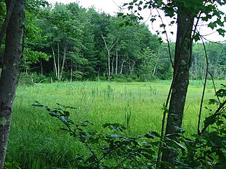
Douglas State Forest is a publicly owned forest with recreational features located in the town of Douglas, Massachusetts, bordering both Connecticut and Rhode Island. The state forest's 5,525 acres (2,236 ha) include Wallum Lake and a rare Atlantic white cedar swamp, 5 acres (2.0 ha) of which are designated as a Massachusetts Wildland. The forest is managed by the Massachusetts Department of Conservation and Recreation.

Dunn State Park is a public recreation area surrounding a 20-acre (8.1 ha) pond in Gardner, Massachusetts. The state park covers 132 acres (53 ha) and is managed by the Department of Conservation and Recreation.
Manuel F. Correllus State Forest is a Massachusetts state forest located on Martha's Vineyard. The forest borders Martha's Vineyard Airport on three sides and is chiefly in the towns of West Tisbury and Edgartown. The forest is managed by the Department of Conservation and Recreation.

Lake Dennison Recreation Area is a 121-acre (49 ha) Massachusetts state park located in the town of Winchendon. It comprises a small portion of the 4,221 acres (1,708 ha) of the U.S. Army Corps of Engineers' Birch Hill Flood Control Project that are managed by the Department of Conservation and Recreation and that also include Otter River State Forest.

Lawrence Heritage State Park is a history-themed public recreation area dedicated to preserving the industrial heritage of Lawrence, Massachusetts. The state park comprises three separate units on or near the Merrimack River. It is managed by the Massachusetts Department of Conservation and Recreation.

Fall River Heritage State Park is a history-themed public recreation area on the Taunton River in Fall River, Massachusetts. The state park encompasses 14 acres (5.7 ha) beside the Charles M. Braga Jr. Memorial Bridge on Battleship Cove, home of the World War II battleship USS Massachusetts. The park is managed by the Massachusetts Department of Conservation and Recreation.

October Mountain State Forest is a 16,460-acre (6,660 ha) forest and recreational preserve located primarily in the town of Washington with adjoining parcels in Becket, Lee, and Lenox. It is the largest state forest in Massachusetts and is managed by the Massachusetts Department of Conservation and Recreation.
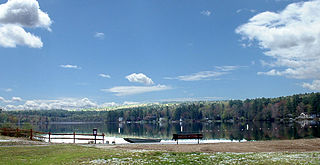
Lake Wyola is a lake located in Shutesbury, Massachusetts, United States.
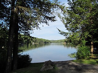
Erving State Forest is a publicly owned forest with recreational features located north of the Millers River in the towns of Erving, Warwick, and Orange, Massachusetts. The property is centered on Laurel Lake, a 51-acre (21 ha) body of water that has been a popular recreational destination since the 1930s. The forest's network of roads and hiking trails were largely created by the Civilian Conservation Corps. The forest is managed by the Department of Conservation and Recreation.
The D.A.R. State Forest is a publicly owned forest with recreational features located mostly in the town of Goshen with some spillage into neighboring Ashfield, Massachusetts. Activities center around Upper and Lower Highland Lakes. The state forest encompasses 1,728 acres (699 ha) and is managed by the Department of Conservation and Recreation.
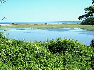
Ellisville Harbor State Park is a nature preserve and public recreation area located in the village of Ellisville, Massachusetts, United States, on the western shore of Cape Cod Bay. Natural features of the coastal property include a barrier beach, sphagnum bog, salt marsh, rolling meadows, and red pine forest habitats. Scenic features include views of the South Shore coastline, small fishing boats, harbor seals seen offshore during fall and winter, and birds attracted to the park's bog as both habitat and migration stopover. The state park is managed by the Department of Conservation and Recreation.

Tolland State Forest is a publicly owned forest with recreational features covering 4,415 acres (1,787 ha) in the towns of Otis, Tolland, Blandford and Sandisfield in the southern Berkshire Hills of Massachusetts. The state forest centers on the 1,065-acre (431 ha) Otis Reservoir, the largest body of water for recreational use in western Massachusetts. The forest is managed by the Department of Conservation and Recreation.

Pearl Hill State Park is a 1,000-acre (400 ha) Massachusetts state park located in the town of Townsend about 50 miles (80 km) from Boston. The park lies adjacent to Willard Brook State Forest and is managed by the Department of Conservation and Recreation (DCR).

Quinsigamond State Park is a public recreation area comprising two day-use areas along the western shore of Lake Quinsigamond in the city of Worcester, Massachusetts. The Regatta Point area is across North Lake Avenue from the University of Massachusetts Medical School, north of Route 9. The Lake Park area is south of Route 9. The park is managed by the Department of Conservation and Recreation.


