Frederick Law Olmsted was an American landscape architect, journalist, social critic, and public administrator. He is considered to be the father of landscape architecture in the United States. Olmsted was famous for co-designing many well-known urban parks with his partner Calvert Vaux. Olmsted and Vaux's first project was New York's Central Park, which led to many other urban park designs, including Prospect Park in Brooklyn and Cadwalader Park in Trenton, New Jersey. He headed the preeminent landscape architecture and planning consultancy of late 19th century United States, which was carried on and expanded by his sons, Frederick Jr. and John C., under the name Olmsted Brothers.
Brookline is a town in Norfolk County, Massachusetts, United States, and part of the Boston metropolitan area. Brookline borders six of Boston's neighborhoods: Brighton, Allston, Fenway–Kenmore, Mission Hill, Jamaica Plain, and West Roxbury. The city of Newton lies to the west of Brookline. Brookline was first settled in 1638 as a hamlet in Boston, known as Muddy River; it was incorporated as a separate town in 1705.

Chestnut Hill is a wealthy New England village located six miles (10 km) west of downtown Boston, Massachusetts, United States. Like all Massachusetts villages, Chestnut Hill is not an incorporated municipal entity. It is located partially in Brookline in Norfolk County; partially in the city of Boston in Suffolk County, and partially in the city of Newton in Middlesex County. Chestnut Hill's borders are defined by the 02467 ZIP Code. The name refers to several small hills that overlook the 135-acre Chestnut Hill Reservoir rather than one particular hill. Chestnut Hill is best known as the home of Boston College and as part of the Boston Marathon route.

The Emerald Necklace consists of a 1,100-acre chain of parks linked by parkways and waterways in Boston and Brookline, Massachusetts. It was designed by landscape architect Frederick Law Olmsted, and gets its name from the way the planned chain appears to hang from the "neck" of the Boston peninsula. In 1989, the Emerald Necklace was designated as a Boston Landmark by the Boston Landmarks Commission.

The Gardens at Elm Bank, home of Massachusetts Horticultural Society, occupies 36 acres (15 ha) of Elm Bank Reservation, a 175-acre (71 ha) recreational area of woodlands, fields, and former estate property on the Charles River managed by the Massachusetts Department of Conservation and Recreation. The estate's entrance is located at 900 Washington Street, Wellesley, Massachusetts, United States, with the major portion of the grounds located in the neighboring town of Dover. In 1987, the entire site was added to the National Register of Historic Places as Elm Bank.

The Olmsted Brothers company was a landscape architectural firm in the United States, established in 1898 by brothers John Charles Olmsted (1852–1920) and Frederick Law Olmsted Jr. (1870–1957), sons of the landscape architect Frederick Law Olmsted.
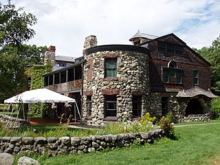
The Robert Treat Paine Estate, known as Stonehurst, is a country house set on 109 acres (44 ha) in Waltham, Massachusetts. It was designed for philanthropist Robert Treat Paine (1835-1910) in a collaboration between architect Henry Hobson Richardson and landscape architect Frederick Law Olmsted. It is located at 100 Robert Treat Paine Drive. Since 1974 the estate has been owned by the City of Waltham and its grounds kept as a public park, and is believed to be the only residential collaboration by Richardson and Olmsted that is open to the public.
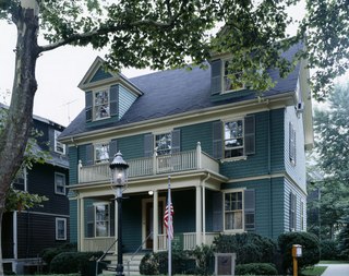
The John Fitzgerald Kennedy National Historic Site is the birthplace and childhood home of John F. Kennedy, the 35th president of the United States. The house is at 83 Beals Street in the Coolidge Corner neighborhood of Brookline, Massachusetts. Kennedy is one of four U.S. presidents born in Norfolk County, Massachusetts. The property is now owned by the National Park Service; tours of the house are offered, and a film is presented.
Planting Fields Arboretum State Historic Park, which includes the Coe Hall Historic House Museum, is an arboretum and state park covering over 400 acres (160 ha) located in the village of Upper Brookville in the town of Oyster Bay, New York.
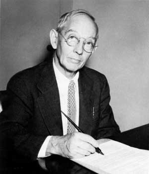
Frederick Law Olmsted Jr. was an American landscape architect and city planner known for his wildlife conservation efforts. He had a lifetime commitment to national parks, and worked on projects in Acadia, the Everglades and Yosemite National Park. He gained national recognition by filling in for his father on the Park Improvement Commission for the District of Columbia beginning in 1901, and by contributing to the famous McMillan Commission Plan for redesigning Washington according to a revised version of the original L’Enfant plan. Olmsted Point in Yosemite and Olmsted Island at Great Falls of the Potomac River in Maryland are named after him.

Jamaicaway is a four-lane, undivided parkway in the Jamaica Plain neighborhood of Boston, Massachusetts, United States, near the border of Brookline.

Riverway, also referred to as "the Riverway," is a parkway in Boston, Massachusetts. The parkway is a link in the Emerald Necklace system of parks and parkways designed by Frederick Law Olmsted in the 1890s. Starting at the Landmark Center end of the Back Bay Fens, the parkway follows the path of the Muddy River south to Olmsted Park across a stone bridge over Route 9 near Brookline Village. The road and its associated park form Boston's western border with neighboring Brookline and are popular with nearby local residents in both municipalities.
Wheatleigh is a historic country estate on West Hawthorne Road in Stockbridge, Massachusetts, United States. Built in 1893 to a design by Peabody and Stearns, it is one of the few surviving great Berkshire Cottages of the late 19th century, with grounds landscaped by Frederick Law Olmsted. Its estate now reduced to 22 acres (8.9 ha), Wheatleigh was listed on the National Register of Historic Places in 1982. It is now operated as a hotel.

The Newton Railroad Stations Historic District in Newton, Massachusetts is composed of three geographically separate historic railroad stations and one baggage/express building on the former Boston and Albany Railroad Highland branch, which was converted to MBTA Green Line D branch in 1959.

Union Station is a historic former railroad station located in downtown Palmer, Massachusetts. The building, which was designed by American architect H. H. Richardson, opened in June 1884 to consolidate two separate stations nearby. The grounds of the station were originally designed by Frederick Law Olmsted.
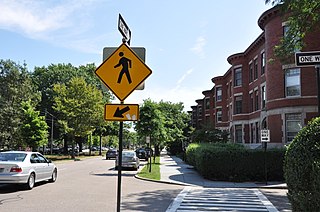
The Beacon Street Historic District is a historic district running most of the length of Beacon Street in Brookline, Massachusetts, roughly from Saint Mary's Road, near Kenmore Square, to Ayr Road near Cleveland Circle. It includes a small number of properties on adjacent streets, and was listed on the National Register of Historic Places in 1985.

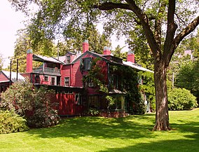
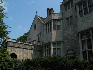
The Lewis Cabot Estate was a historic estate at Warren and Heath Streets in Brookline, Massachusetts. The estate, developed in 1894, was one of few surviving turn-of-the-century properties of the Boston Brahmin Cabot family, and a prominent local example of Jacobethan architecture with landscaping by Frederick Law Olmsted. The remnant portion of the estate was listed on the National Register of Historic Places in 1985; the main house has since been demolished.

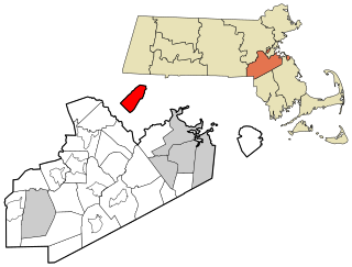
The Fisher Hill Historic District encompasses a residential area in central Brookline, Massachusetts. The area was subdivided and built out beginning in the 1880s, with landscaping design by Frederick Law Olmsted and John Charles Olmsted. The district is bounded on the west by Chestnut Hill Avenue, Baxter Road, and Channing Road, and on the south by Massachusetts Route 9. Its eastern boundary runs along Buckminster Street to Dean Road, joining the northern boundary of Clinton Road, running between Dean Road and Chestnut Hill Avenue. Prior to its development in the 1880s, Fisher Hill had a relatively small number of landowners. Some of them banded together, hiring the Olmsteds to design a subdivision plan for the entire district. Lots were sold to wealthy individuals, who built fashionable houses, often designed by architects. In 1914 a restrictive covenant was entered into by a significant number of property owners, restricting their properties to strictly single-family residential uses.

Park Drive is a mostly one-way, two-lane parkway in the Fenway-Kenmore neighborhood of Boston that runs along the northern and western edges of the Back Bay Fens before ending at Mountfort Street. As part of the Emerald Necklace park system mainly designed by Frederick Law Olmsted in the late 19th century, Park Drive, along with the Back Bay Fens and the Fenway, connects the Commonwealth Avenue Mall and Boylston Street to Beacon Street and the Riverway. For a portion of its length, the parkway runs along the Muddy River and is part of the Metropolitan Park System of Greater Boston's Muddy River Reservation. Like others in the park system, it is maintained by the Massachusetts Department of Conservation and Recreation.