Brookline is a town in Norfolk County, Massachusetts, United States, and part of the Boston metropolitan area. Brookline borders six of Boston's neighborhoods: Brighton, Allston, Fenway–Kenmore, Mission Hill, Jamaica Plain, and West Roxbury. The city of Newton lies to the west of Brookline. Brookline was first settled in 1638 as a hamlet in Boston, known as Muddy River; it was incorporated as a separate town in 1705.
Fenway–Kenmore is an officially recognized neighborhood of Boston, Massachusetts. While it is considered one neighborhood for administrative purposes, it is composed of numerous distinct sections that, in casual conversation, are almost always referred to as "Fenway", "the Fenway", "Kenmore Square", or "Kenmore". Furthermore, the Fenway neighborhood is divided into two sub-neighborhoods commonly referred to as East Fenway/Symphony and West Fenway.

Chestnut Hill is a wealthy New England village located six miles (10 km) west of downtown Boston, Massachusetts, United States. It is best known for being home to Boston College and a section of the Boston Marathon route. Like all Massachusetts villages, Chestnut Hill is not an incorporated municipal entity. It is located partially in Brookline in Norfolk County; partially in the city of Boston in Suffolk County, and partially in the city of Newton in Middlesex County. Chestnut Hill's borders are defined by the 02467 ZIP Code. The name refers to several small hills that overlook the 135-acre Chestnut Hill Reservoir rather than one particular hill.

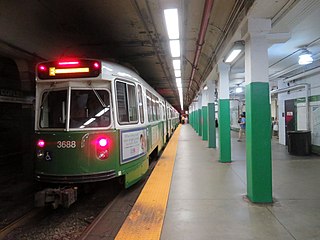
Hynes Convention Center station is an underground light rail station on the Massachusetts Bay Transportation Authority (MBTA) Green Line. It is located at the intersection of Newbury Street and Massachusetts Avenue near the western end of the Back Bay neighborhood of Boston, Massachusetts. The station is named for the Hynes Convention Center, which is located about 700 feet (210 m) to the east along Boylston Street. It has two side platforms serving the two tracks of the Boylston Street subway, which are used by the Green Line B branch, C branch, and D branch. The main entrance to the station from Massachusetts Avenue leads to a fare lobby under the 360 Newbury Street building.
Washington Street is a street originating in downtown Boston, Massachusetts, which extends southwestward to the Massachusetts–Rhode Island state line. The majority of its length outside of the city was built as the Norfolk and Bristol Turnpike in the early 19th century. It is the longest street in Boston and remains one of the longest streets in the Commonwealth of Massachusetts. Due to various municipal annexations with the city of Boston, the name Washington Street now exists 6 or more times within the jurisdiction(s) of the City of Boston.

The C branch, also called the Beacon Street Line or Cleveland Circle Line, is one of four branches of the Massachusetts Bay Transportation Authority's Green Line light rail system in the Boston, Massachusetts metropolitan area. The line begins at Cleveland Circle in the Brighton neighborhood of Boston and runs on the surface through Brookline along the median of Beacon Street. Reentering Boston, the line goes underground through the St. Mary's Street incline and joins the B and D branches at Kenmore. Trains run through the Boylston Street subway to Copley where the E branch joins, then continue through the Tremont Street subway to downtown Boston. The C branch has terminated at Government Center station since October 2021.
Copley station is an underground light rail station on the MBTA Green Line, located in the Back Bay section of Boston, Massachusetts. Located in and named after Copley Square, the station has entrances and exits along Boylston Street and Dartmouth Street.

Huntington Avenue is a thoroughfare in the city of Boston, Massachusetts, beginning at Copley Square and continuing west through the Back Bay, Fenway, Longwood, and Mission Hill neighborhoods. It is signed as Massachusetts Route 9. A section of Huntington Avenue has been officially designated the Avenue of the Arts by the city of Boston.
Brookline Village station is a light rail station on the MBTA Green Line D branch, located in the Brookline Village neighborhood of Brookline, Massachusetts, United States. It was originally a commuter rail station on the Boston and Albany Railroad's Highland branch; it closed with the rest of the line in 1958 and reopened on July 4, 1959 as a light rail station. With 3,230 daily boardings, it is the third-busiest surface station on the D branch and the sixth-busiest surface station overall. Brookline Village station has raised platforms for accessibility with low-floor light rail vehicles.
Beacon Street is a major thoroughfare in Boston, Massachusetts and its western suburbs Brookline and Newton. It passes through many of Boston's central and western neighborhoods, including Beacon Hill, Back Bay, Fenway–Kenmore, the Boston University campus, Brighton, and Chestnut Hill.

Charles Street is the name of a north-south street in the city center of Boston, Massachusetts. It begins in the north at Leverett Circle, where it connects with Nashua Street and Monsignor O'Brien Highway. Science Park station on the MBTA Green Line is located there. Charles Street runs south and gives its name to the Charles/MGH station on the MBTA Red Line, connecting via the Charles Circle rotary to Cambridge Street and the Longfellow Bridge which leads to Cambridge. This segment is a one-way street, with traffic heading northwards.

Boylston Street is a major east–west thoroughfare in the city of Boston, Massachusetts and its western suburbs. The street begins in Boston's Chinatown neighborhood, forms the southern border of the Boston Public Garden and Boston Common, runs through Back Bay and Boston's Fenway neighborhood, merges into Brookline Ave and then Washington Street, emerging again contiguous with Route 9 out to where it crosses Route 128, after which it becomes Worcester Street.

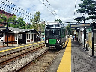
Brookline Hills station is a light rail station on the Massachusetts Bay Transportation Authority (MBTA) Green Line D branch in the Brookline Hills neighborhood of Brookline, Massachusetts. The station has two side platforms serving the line's two tracks. It was closed from April 2021 to January 2022 as part of adjacent construction on a Brookline High School building, which included renovations to make the station accessible.
Carl Fehmer was a prominent German-American Boston architect during the 19th century.

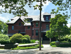
The Hotel Adelaide is a historic apartment house at 13–21 High Street in the Pill Hill neighborhood of Brookline, Massachusetts, United States. Built in 1875, it is one of the earliest known examples of a duplex-style apartment house, in which the individual units occupy space on two floors, connected by a private staircase. The building and added to the National Register of Historic Places in 1985.

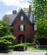
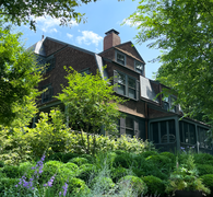
The Pill Hill Historic District is a historic district roughly bounded by Boylston Street, Pond Ave., and Acron, Oakland and Highland Roads in Brookline, Massachusetts.

Hartwell and Richardson was a Boston, Massachusetts architectural firm established in 1881, by Henry Walker Hartwell (1833–1919) and William Cummings Richardson (1854–1935). The firm contributed significantly to the current building stock and architecture of the greater Boston area. Many of its buildings are listed on the National Register of Historic Places.

Kilham & Hopkins was an architectural firm in Boston, Massachusetts formed in 1899 or 1900 by its founding members, Walter Harrington Kilham and James Cleveland Hopkins. The firm later became Kilham, Hopkins & Greeley after William Roger Greeley joined the firm in 1916, and Kilham Hopkins Greeley and Brodie after Walter S. (Steve) Brodie joined the firm in 1945.

Fort Hill is a 0.4 square mile neighborhood and historic district of Roxbury, in Boston, Massachusetts. The approximate boundaries of Fort Hill are Malcolm X Boulevard on the north, Washington Street on the southeast, and Columbus Avenue on the southwest.

The Ipswich Street line was a streetcar line in Boston and Brookline, Massachusetts. The line ran on Boylston Street and Ipswich Street in the Fenway–Kenmore neighborhood, and on Brookline Avenue through what is now the Longwood Medical Area to Brookline Village.