Brookline is a town in Norfolk County, Massachusetts, United States, and part of the Boston metropolitan area. An exclave of Norfolk County, Brookline borders six of Boston's neighborhoods: Brighton, Allston, Fenway–Kenmore, Mission Hill, Jamaica Plain, and West Roxbury. The city of Newton borders Brookline to the west. It is known as the birthplace of John F. Kennedy.

Fenway–Kenmore is an officially recognized neighborhood of Boston, Massachusetts, United States. While it is considered one neighborhood for administrative purposes, it is composed of numerous distinct sections that, in casual conversation, are almost always referred to as "Fenway", "the Fenway", "Kenmore Square", or "Kenmore". Furthermore, the Fenway neighborhood is divided into two sub-neighborhoods commonly referred to as East Fenway/Symphony and West Fenway.

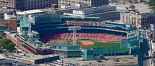
Kenmore Square is a square in the Fenway–Kenmore neighborhood of Boston, Massachusetts. It is formed by the crossing of Beacon Street, Commonwealth Avenue, and Brookline Avenue. It is the eastern terminus of U.S. Route 20, the longest U.S. Highway. The Citgo sign is a prominent landmark in Kenmore Square, and Fenway Park is just to the south. Kenmore station is located under the square, with a surface bus terminal inside the square.

Chestnut Hill is a wealthy New England village located six miles (10 km) west of downtown Boston, Massachusetts, United States. It is best known for being home to Boston College and a section of the Boston Marathon route. Like all Massachusetts villages, Chestnut Hill is not an incorporated municipal entity. It is located partially in Brookline in Norfolk County; partially in the city of Boston in Suffolk County, and partially in the city of Newton in Middlesex County. Chestnut Hill's borders are defined by the 02467 ZIP Code. The name refers to several small hills that overlook the 135-acre Chestnut Hill Reservoir rather than one particular hill.

Cleveland Circle is an area of Boston, Massachusetts. It is located at the southern tip of Boston's Brighton neighborhood, and more specifically the Aberdeen section of Brighton, in close proximity to Brookline and Chestnut Hill, Massachusetts, at the intersection of Beacon Street and Chestnut Hill Avenue.

Reservoir station is a light rail station on the MBTA Green Line D branch, located in Brookline, Massachusetts, adjacent to the Cleveland Circle area of Brighton. The station is adjacent to Reservoir Yard and Carhouse, with the Cleveland Circle terminus of the C branch just a block away. With a daily ridership of 3,395, Reservoir is the second-busiest surface stop on the D branch.

The West End Street Railway was a streetcar company that operated in Boston, Massachusetts and several surrounding communities in the late nineteenth century.

The C branch, also called the Beacon Street Line or Cleveland Circle Line, is one of four branches of the Massachusetts Bay Transportation Authority's Green Line light rail system in the Boston, Massachusetts metropolitan area. The line begins at Cleveland Circle in the Brighton neighborhood of Boston and runs on the surface through Brookline along the median of Beacon Street. Reentering Boston, the line goes underground through the St. Mary's Street incline and joins the B and D branches at Kenmore. Trains run through the Boylston Street subway to Copley where the E branch joins, then continue through the Tremont Street subway to downtown Boston. The C branch has terminated at Government Center station since October 2021.
Allston–Brighton is a set of two interlocking neighborhoods, Allston and Brighton, both part of the city of Boston, Massachusetts.

The Ware Millyard Historic District encompasses a 19th-century mill complex and industrial mill village in the town of Ware, Massachusetts. It is roughly bounded by South Street, the Ware River, Upper Dam Complex, Park Street, Otis Avenue and Church Street. The area includes surviving mill buildings, the oldest of which date to the 1840s, and a collection of tenement-style housing built for the millworkers, built between 1845 and the 1880s.

The Commonwealth Avenue Historic District of Newton, Massachusetts, encompasses roughly the eastern half of Commonwealth Avenue, extending from Waban Hill Road, near the city line with Boston, westward to Walnut Street. The roadway was laid out in 1894 and completed in 1895. Its design was influenced in part by the local residents, who were willing to give land for some of the route, and the design of Boston portions of the road, in which Frederick Law Olmsted was involved. Construction of the roadway was followed by the construction of fashionably large residences along its route, which took place mostly between the road's construction and about 1920. The district includes 188 residential properties, which are mainly built in the revival styles popular in the early 20th century. The district was added to the National Register of Historic Places in 1990.

The Crystal Lake and Pleasant Street Historic District encompasses a streetcar suburban residential subdivision developed between 1860 and 1895 in Newton, Massachusetts. The district roughly bounded by the Sudbury Aqueduct, Pleasant Street, Lake Avenue, Webster Court, and Crystal Street. The subdivision was laid out in the 1850s after the Boston and Charles Railroad line was extended through Newton from Brookline. The district was listed on the National Register of Historic Places in 1986.

The Monadnock Road Historic District is a residential historic district encompassing a cohesive subdivision of a former estate in the 1920s in the Chestnut Hill section of Newton, Massachusetts. The development was typical of Newton's explosive residential growth at that time, and includes primarily Tudor Revival houses. The district was listed on the National Register of Historic Places in 1990.

The Old Chestnut Hill Historic District encompasses the historic residential heart of the Newton portion of Chestnut Hill, Massachusetts. When first listed on the National Register of Historic Places in 1986, the district extended along Hammond Street, between Beacon Street and the MBTA Green Line right-of-way, and along Chestnut Hill Road between Hammond and Essex, including properties along a few adjacent streets. The district was expanded in 1990 to include more of Chestnut Hill Road and Essex Road, Suffolk Road and the roads between it and Hammond, and a small section south of the Green Line including properties on Hammond Street, Longwood Road, and Middlesex Road. A further expansion in 1999 added a single property on Suffolk Road.

The Beaconsfield Terraces Historic District is a residential historic district at 11–25, 33–43, and 44–55 Garrison Rd. and 316–326, 332–344, and 350–366 Tappan Street in Brookline, Massachusetts. It encompasses a collection of architecturally distinctive row houses that were built between 1889 and 1892 by a single developer, and represent a unique early success in condominium ownership. The district was listed on the National Register of Historic Places in 1985.

The Fisher Hill Historic District encompasses a residential area in central Brookline, Massachusetts. The area was subdivided and built out beginning in the 1880s, with landscaping design by Frederick Law Olmsted and John Charles Olmsted. The district is bounded on the west by Chestnut Hill Avenue, Baxter Road, and Channing Road, and on the south by Massachusetts Route 9. Its eastern boundary runs along Buckminster Street to Dean Road, joining the northern boundary of Clinton Road, running between Dean Road and Chestnut Hill Avenue. Prior to its development in the 1880s, Fisher Hill had a relatively small number of landowners. Some of them banded together, hiring the Olmsteds to design a subdivision plan for the entire district. Lots were sold to wealthy individuals, who built fashionable houses, often designed by architects. In 1914 a restrictive covenant was entered into by a significant number of property owners, restricting their properties to strictly single-family residential uses.

Hammond Pond Parkway is a historic parkway in Chestnut Hill, Massachusetts. The road, built in 1932, extends 2 miles (3.2 km) from Hobart Road in Newton to Horace James Circle in Brookline, where it joins the West Roxbury Parkway. It was designed by Charles Eliot and the Olmsted Brothers to provide a parkway setting that provided access from Brookline, Newton, and the western portions of Boston to the southern parks of the Emerald Necklace. The parkway was listed on the National Register of Historic Places in 2004.

The Strathmore Road Historic District is a residential historic district on Strathmore Road and Clinton Path in Brookline, Massachusetts. It consists of six brick apartment blocks, four of which lie on Strathmore Road, and two of which lie on Clinton Path. The two streets form a loop just south of the westernmost portion of Beacon Street, and abutting the MBTA Green Line yard at Cleveland Circle. The district is reflective of the area's growth as a commuter suburb following the development of the rail line along Beacon Street, and was listed on the National Register of Historic Places in 1985.

The Longwood Historic District is roughly bounded by Chapel, St. Marys, Monmouth, and Kent Sts. in Brookline, Massachusetts. The area was developed in the mid-19th century by David Sears and Amos Adams Lawrence as a fashionable residential area, and retains a number of architecturally distinguished buildings, including the Longwood Towers complex at 20 Chapel Street, Christ's Church Longwood, and Church of Our Saviour, Brookline. The district was listed on the National Register of Historic Places on September 13, 1978.

The Sisson-South Whitney Historic District encompasses a neighborhood in the West End area of Hartford, Connecticut, that was built out between 1890 and 1930 as a streetcar suburb. It is roughly bounded by Farmington Avenue, South Whitney Street, West Boulevard, and Sisson Avenue, and includes a diversity of residential and commercial architecture, reflective of its initial development and subsequent growth. The district was listed on the National Register of Historic Places in 2013.


