
Brookline is a town in Norfolk County, Massachusetts, United States, and part of the Boston metropolitan area. An exclave of Norfolk County, Brookline borders six of Boston's neighborhoods: Brighton, Allston, Fenway–Kenmore, Mission Hill, Jamaica Plain, and West Roxbury. The city of Newton borders Brookline to the west. It is known as the birthplace of John F. Kennedy.

The Old South Meeting House is a historic Congregational church building located at the corner of Milk and Washington Streets in the Downtown Crossing area of Boston, Massachusetts, built in 1729. It gained fame as the organizing point for the Boston Tea Party on December 16, 1773. Five thousand or more colonists gathered at the Meeting House, the largest building in Boston at the time.

Longwood station is a light rail station on the MBTA Green Line D branch, located on Chapel Street in Brookline, Massachusetts, on the border with Boston, just north of Longwood Avenue. It serves the Longwood Medical Area, the Colleges of the Fenway, and residential areas of Brookline. The station opened with the rest of the line on July 4, 1959. After renovation work completed in 2009, Longwood station is accessible from both Chapel Street and Riverway Park.

Chestnut Hill is a wealthy New England village located six miles (10 km) west of downtown Boston, Massachusetts, United States. It is best known for being home to Boston College and a section of the Boston Marathon route. Like all Massachusetts villages, Chestnut Hill is not an incorporated municipal entity. It is located partially in Brookline in Norfolk County; partially in the city of Boston in Suffolk County, and partially in the city of Newton in Middlesex County. Chestnut Hill's borders are defined by the 02467 ZIP Code. The name refers to several small hills that overlook the 135-acre Chestnut Hill Reservoir rather than one particular hill.

The E branch is a light rail line in Boston, Cambridge, Medford, and Somerville, Massachusetts, operating as part of the Massachusetts Bay Transportation Authority (MBTA) Green Line. The line runs in mixed traffic on South Huntington Avenue and Huntington Avenue between Heath Street and Brigham Circle, in the median of Huntington Avenue to Northeastern University, then into the Huntington Avenue subway. The line merges into the Boylston Street subway just west of Copley, running to North Station via the Tremont Street subway. It then follows the Lechmere Viaduct to Lechmere, then the Medford Branch to Medford/Tufts. As of February 2023, service operates on eight-minute headways at weekday peak hours and eight to nine-minute headways at other times, using 13 to 17 trains.

Old South Church in Boston, Massachusetts, also known as New Old South Church or Third Church, is a historic United Church of Christ congregation first organized in 1669. Its present building was designed in the Gothic Revival style by Charles Amos Cummings and Willard T. Sears, completed in 1873, and amplified by the architects Allen & Collens between 1935–1937. The church, which was built on newly filled land in the Back Bay section of Boston, is located at 645 Boylston Street on Copley Square. It was designated a National Historic Landmark in 1970 for its architectural significance as one of the finest High Victorian Gothic churches in New England. It is home to one of the oldest religious communities in the United States.

David Sears II was a prominent 19th-century Boston philanthropist, merchant, real estate developer, and landowner.

The Landmark Center or 401 Park Building in Boston, Massachusetts is a commercial center situated in a limestone and brick art deco building built in 1928 for Sears, Roebuck and Company. It features a 200-foot-tall (61 m) tower and, as Sears Roebuck and Company Mail Order Store, it is listed on the National Register of Historic Places and designated as a Boston Landmark in 1989.

The Muddy River is a series of brooks and ponds that runs through sections of Boston's Emerald Necklace, including along the south boundary of Brookline, Massachusetts. The river, which is narrower than most waterways designated as rivers in the United States, is a protected public recreation area surrounded by parks and hiking trails, managed by the Massachusetts Department of Conservation and Recreation.

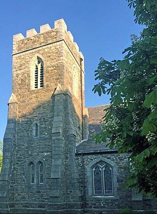
Saint Aidan's Church and Rectory is a historic Catholic church complex in Brookline, Massachusetts. The stuccoed church, located at 224-210 Freeman Street, was designed by Maginnis & Walsh, a noted designer of ecclesiastical buildings, in the Medieval (Tudor) Revival style, and was built in 1911. It was Brookline's third Catholic parish, after Saint Mary's and Saint Lawrence. The church is notable as the parish which was attended by Joseph P. Kennedy and his family when they were living on Beals Street; it was the site of the baptism of both John F. Kennedy and Robert F. Kennedy. The rectory, located at 158 Pleasant Street, was built c. 1850-55 by Edward G. Parker, a Boston lawyer. It was acquired by the church in 1911, and restyled to match the church in 1920.
The Church of Our Saviour is a parish of the Episcopal Diocese of Massachusetts in the Longwood neighborhood of Brookline, Massachusetts, which is now located in the Longwood Historic District (Massachusetts). The church is located at the corner of Carlton and Monmouth Streets, one block from Beacon Street and two blocks from Park Drive. The street address is 25 Monmouth St., Brookline MA. The parish recently celebrated its 150th anniversary.
The Crystal Lake and Pleasant Street Historic District encompasses a streetcar suburban residential subdivision developed between 1860 and 1895 in Newton, Massachusetts. The district roughly bounded by the Sudbury Aqueduct, Pleasant Street, Lake Avenue, Webster Court, and Crystal Street. The subdivision was laid out in the 1850s after the Boston and Charles Railroad line was extended through Newton from Brookline. The district was listed on the National Register of Historic Places in 1986.

The Brookline Town Green Historic District encompasses the historic colonial heart of the town of Brookline, Massachusetts. Centered on a stretch of Walnut Street between Warren and Chestnut Streets, this area is where the town's first colonial meeting house and cemetery were laid out, and was its center of civic life until the early 19th century. The district was listed on the National Register of Historic Places in 1980.

Brookline Village is one of the major commercial and retail centers of the town of Brookline, Massachusetts, United States. Located just north of Massachusetts Route 9 and west of the Muddy River, it is the historic center of the town and includes its major civic buildings, including town hall and the public library. The commercial spine of the village, extending along Washington Street from Route 9 to the library, is a historic district listed on the National Register of Historic Places as the Brookline Village Commercial District.

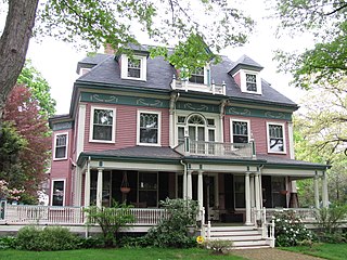
The Cottage Farm Historic District is a residential area in eastern Brookline, Massachusetts, United States, known for its association with industrialist Amos Adams Lawrence (1814–1886). Laid out in the 1850s and centered around the junction of Essex and Ivy Streets, it features high-quality housing on large lots, built between the 1850s and 1910s. The district was listed on the National Register of Historic Places in 1978.

Saint Mary of the Assumption Church, Rectory, School and Convent is a historic church complex at 67 Harvard Street, and 3 and 5 Linden Place, in Brookline, Massachusetts in the Archdiocese of Boston. It was the first Roman Catholic Church in Brookline, and the first in the nation to bear the name. Most of its buildings were built between 1880 and 1906, and are reflective of the growth of the area's Irish immigrant community during that time. The complex was listed on the National Register of Historic Places in 1985.

The Strathmore Road Historic District is a residential historic district on Strathmore Road and Clinton Path in Brookline, Massachusetts. It consists of six brick apartment blocks, four of which lie on Strathmore Road, and two of which lie on Clinton Path. The two streets form a loop just south of the westernmost portion of Beacon Street, and abutting the MBTA Green Line yard at Cleveland Circle. The district is reflective of the area's growth as a commuter suburb following the development of the rail line along Beacon Street, and was listed on the National Register of Historic Places in 1985.
Cummings and Sears was an architecture firm in 19th-century Boston, Massachusetts, established by Charles Amos Cummings and Willard T. Sears.

The Francis Street–Fenwood Road Historic District encompasses a small but cohesive early 20th-century residential area and streetcar suburb in the Longwood area of Boston, Massachusetts. Bounded by Huntington Avenue, Francis Street, Vining Avenue, Fenwood Road, and St. Albans Road, it includes a collection of two and three-family houses, as well as two apartment houses, a school, and one commercial building, all of which predate the large medical complexes that dominate the Longwood area. The district was listed on the National Register of Historic Places in 2016.

The Ipswich Street line was a streetcar line in Boston and Brookline, Massachusetts. The line ran on Boylston Street and Ipswich Street in the Fenway–Kenmore neighborhood, and on Brookline Avenue through what is now the Longwood Medical Area to Brookline Village.


