
Watertown is a city in Middlesex County, Massachusetts, United States, part of Greater Boston. The population was 35,329 in the 2020 census. Its neighborhoods include Bemis, Coolidge Square, East Watertown, Watertown Square, and the West End.

Brighton is a former town and current neighborhood of Boston, Massachusetts, United States, located in the northwestern corner of the city. It is named after the English city of Brighton. Initially Brighton was part of Cambridge, and known as "Little Cambridge". Brighton separated from Cambridge in 1807 after a bridge dispute, and was annexed to Boston in 1874. For much of its early history, it was a rural town with a significant commercial center at its eastern end.
Allston is an officially recognized neighborhood in Boston, Massachusetts, United States. It was named after the American painter and poet Washington Allston. It comprises the land covered by the zip code 02134. For the most part, Allston is administered collectively with the adjacent neighborhood of Brighton. The two are often referred to together as Allston–Brighton. Boston Police Department District D-14 covers the Allston-Brighton area and a Boston Fire Department Allston station is located in Union Square which houses Engine 41 and Ladder 14. Engine 41 is nicknamed "The Bull" to commemorate the historic stockyards of Allston.

Kenmore Square is a square in the Fenway–Kenmore neighborhood of Boston, Massachusetts. It is formed by the crossing of Beacon Street, Commonwealth Avenue, and Brookline Avenue. It is the eastern terminus of U.S. Route 20, the longest U.S. Highway. The Citgo sign is a prominent landmark in Kenmore Square, and Fenway Park is just to the south. Kenmore station is located under the square, with a surface bus terminal inside the square.

The Great Bridge over the Charles River connected Cambridge, Massachusetts, to what is now known as Allston, Boston, Massachusetts. The Great Bridge was built in 1660–1662 at what was then called Brighton Street, and was the first bridge to span the Charles. A toll was authorized in 1670. The bridge was rebuilt in 1862.

The B branch, also called the Commonwealth Avenue branch or Boston College branch, is a branch of the MBTA Green Line light rail system which operates on Commonwealth Avenue west of downtown Boston, Massachusetts. One of four branches of the Green Line, the B branch runs from Boston College station down the median of Commonwealth Avenue to Blandford Street. There, it enters Blandford Street portal into Kenmore station, where it merges with the C and D branches. The combined services run into the Boylston Street subway and Tremont Street subway to downtown Boston. B branch service has terminated at Government Center since October 2021. Unlike the other branches, B branch service runs solely through the city limits of Boston. The Green Line Rivalry between Boston College and Boston University is named in reference to the B branch, which runs to both universities.
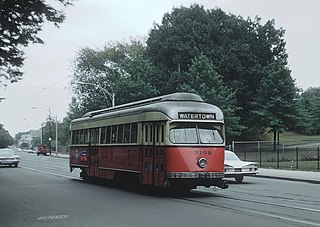
The A branch or Watertown Line was a streetcar line in the Boston, Massachusetts, area, operating as a branch of the Massachusetts Bay Transportation Authority Green Line. The line ran from Watertown through Newton Corner, Brighton, and Allston to Kenmore Square, then used the Boylston Street subway and Tremont Street subway to reach Park Street station.

Commonwealth Avenue is a major street in the cities of Boston and Newton, Massachusetts. It begins at the western edge of the Boston Public Garden, and continues west through the neighborhoods of the Back Bay, Kenmore Square, Boston University, Allston, Brighton and Chestnut Hill. It continues as part of Route 30 through Newton until it crosses the Charles River at the border of the town of Weston.

The Charles River Reservation is a 17-mile-long (27 km) urban preserve and public recreation area located along the banks of the Charles River in Boston, Cambridge, Watertown, and Newton, Massachusetts. The reservation is managed by the Massachusetts Department of Conservation and Recreation.

The Charles River Bike Path is a mixed-use path in the Boston, Massachusetts area. A portion of the trail is named after the cardiologist Paul Dudley White, a prominent advocate of preventive medicine. His research led him to proclaim frequently "I'd like to put everybody on bicycles." In 1955 White served as president Eisenhower's cardiologist and prescribed his famous patient bicycle therapy after his 1955 heart attack.

The Charles River Reservation Parkways are parkways that run along either side of the Charles River in eastern Massachusetts. The roads are contained within the Charles River Reservation and the Upper Charles River Reservation, and fall within a number of communities in the greater Boston metropolitan area. The Charles River parks extend from the Charles River Dam, where the Charles empties into Boston Harbor, to Riverdale Park in the West Roxbury neighborhood of Boston. Most of the roadways within the parks are listed on the National Register of Historic Places as a unit, although Storrow Drive and Memorial Drive are listed as part of the Charles River Basin Historic District.

The River Street Bridge is a bridge on the Charles River in Boston, Massachusetts, connecting River Street in Cambridge to Cambridge Street in Allston near the southern end of the Harvard University campus. It was built in 1925 by the Commonwealth of Massachusetts Metropolitan District Commission.

The Western Avenue Bridge is a bridge carrying Western Avenue over the Charles River between Cambridge and Allston, Massachusetts. It was built in 1924 by the Commonwealth of Massachusetts Metropolitan District Commission.

Packards Corner station is a light rail stop on the MBTA's Green Line B branch located at Packard's Corner—the intersection of Commonwealth Avenue and Brighton Avenue—in Allston, Boston, Massachusetts. The station is located in a median between the westbound travel lanes and frontage road of Commonwealth Avenue.

The North Beacon Street Bridge is a bridge carrying North Beacon Street over the Charles River between Watertown, MA and Brighton, Boston, MA. It was built in 1917.

The Watertown Branch Railroad was a branch loop of the Fitchburg Railroad that was meant to serve the town of Watertown and the City of Waltham, Middlesex County, Massachusetts, as an independent short line railroad; it also serviced the Watertown Arsenal. The line has been formally abandoned and portions have been converted into a rail trail, the Watertown-Cambridge Greenway. A section from School Street to Arlington Street in Watertown was completed first. A small portion in Waltham has been converted into a park called Chemistry Station Park after the railroad station once located there. Construction of an extension to Fresh Pond Reservation in Cambridge began in the summer of 2018 and was completed in June 2022.

Soldiers Field Road is a major crosstown parkway in Boston, Massachusetts, running west to east from U.S. Route 20 in the northwest corner of Brighton to the Boston University Bridge. It follows the course of the Charles River and also passes by the campuses of Harvard University and Boston University. The road is named for the area south of the road on a bend in the Charles River. On June 5, 1890, Henry Lee Higginson presented Harvard College a gift of 31 acres of land, which he called Soldiers Field, given in honor of his friends who died in the Civil War: James Savage, Jr., Charles Russell Lowell, Edward Barry Dalton, Stephen George Perkins, James Jackson Lowell, and Robert Gould Shaw. This land later became the home of Harvard Crimson athletics.

The Charles River Speedway was a former bicycle and harness racing track located in Allston, Massachusetts, which has been redeveloped into an upscale market.

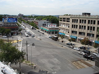
Union Square is a square in the Allston neighborhood of Boston, Massachusetts at the intersection of Cambridge Street and Brighton Avenue/North Beacon Street. Union Square is serviced by the MBTA 57, 64, 66, 501, and 503 buses. There is also a station for the Blue Bikes bicycle sharing system in Union Square.
Arsenal Street may refer to:

