The Green Line is a light rail system run by the Massachusetts Bay Transportation Authority (MBTA) in the Boston, Massachusetts, metropolitan area. It is the oldest Boston rapid transit line, and with tunnel sections dating from 1897, the oldest subway in North America. It runs underground through downtown Boston, and on the surface into inner suburbs via four branches on several radial boulevards. With an average daily weekday ridership of 137,700 in 2019, it is the third most heavily used light rail system in the country. The line was assigned the green color in 1967 during a systemwide rebranding because several branches pass through sections of the Emerald Necklace of Boston.
Back Bay is an officially recognized neighborhood of Boston, Massachusetts, built on reclaimed land in the Charles River basin. Construction began in 1859, as the demand for luxury housing exceeded the availability in the city at the time, and the area was fully built by around 1900. It is most famous for its rows of Victorian brownstone homes—considered one of the best preserved examples of 19th-century urban design in the United States—as well as numerous architecturally significant individual buildings, and cultural institutions such as the Boston Public Library, and Boston Architectural College. Initially conceived as a residential-only area, commercial buildings were permitted from around 1890, and Back Bay now features many office buildings, including the John Hancock Tower, Boston's tallest skyscraper. It is also considered a fashionable shopping destination and home to several major hotels.

U.S. Route 3 (US 3) is a United States highway running 277.9 miles (447.2 km) from Boston, Massachusetts, through New Hampshire, to the Canada–US border near Third Connecticut Lake, where it connects to Quebec Route 257.

The Back Bay Fens, often called The Fens, is a parkland and urban wild in Boston, Massachusetts, in the United States. It was established in 1879. Designed by Frederick Law Olmsted to serve as a link in the Emerald Necklace park system, the Fens gives its name to the Fenway-Kenmore neighborhood.

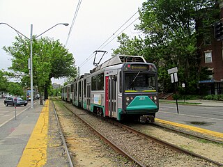
The B branch, also called the Commonwealth Avenue branch or Boston College branch, is a branch of the MBTA Green Line light rail system which operates on Commonwealth Avenue west of downtown Boston, Massachusetts. One of four branches of the Green Line, the B branch runs from Boston College station down the median of Commonwealth Avenue to Blandford Street. There, it enters Blandford Street portal into Kenmore station, where it merges with the C and D branches. The combined services run into the Boylston Street subway and Tremont Street subway to downtown Boston. B branch service has terminated at Government Center since October 2021. Unlike the other branches, the B branch runs solely through the city limits of Boston. The Green Line Rivalry between Boston College and Boston University is named in reference to the B branch, which runs to both universities.
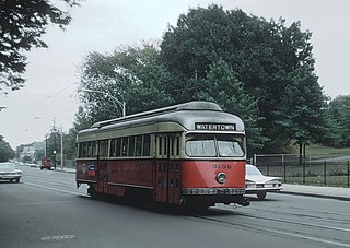
The A branch or Watertown Line was a streetcar line in the Boston, Massachusetts, area, operating as a branch of the Massachusetts Bay Transportation Authority Green Line. The line ran from Watertown through Newton Corner, Brighton, and Allston to Kenmore Square, then used the Boylston Street subway and Tremont Street subway to reach Park Street station.

The Fitchburg Railroad is a former railroad company, which built a railroad line across northern Massachusetts, United States, leading to and through the Hoosac Tunnel. The Fitchburg was leased to the Boston and Maine Railroad in 1900. The main line from Boston to Fitchburg is now operated as the MBTA Fitchburg Line; Pan Am Railways runs freight service on some other portions.

Watertown Square is the main square of Watertown, Massachusetts, located at the confluence of North Beacon Street and Main Street (US-20), Mt. Auburn Street (MA-16), Pleasant Street, Arsenal Street, and Charles River Road. The Armenian Library and Museum of America is located in the square; Watertown Dam is 1,000 feet (300 m) to the west.

Route 28 is a 151.93-mile-long (244.51 km) nominally south–north state highway in the U.S. state of Massachusetts, running from the town of Eastham via Boston to the New Hampshire state line in Methuen. Following the route from its nominally southern end, Route 28 initially heads south to the town of Chatham then turns west to follow along the south shore of Cape Cod. In Falmouth, Route 28 turns north and continues through the western part of Plymouth County and the eastern part of Norfolk County; it then passes through downtown Boston before heading north via Lawrence to the New Hampshire state line, where it continues as New Hampshire Route 28.

Route 8 is a 67.36-mile (108.41 km) state highway in Connecticut that runs north–south from Bridgeport, through Waterbury, all the way to the Massachusetts state line where it continues as Massachusetts Route 8. Most of the highway is a four-lane freeway but the northernmost 8.8 miles (14.2 km) is a two-lane surface road.

Memorial Drive is a 3.9-mile (6.3 km) parkway along the north bank of the Charles River in Cambridge, Massachusetts, United States. It runs parallel to two major Boston parkways - Soldiers Field Road and Storrow Drive - which lie on the south bank of the river. The western terminus is in West Cambridge at Greenough Boulevard and Fresh Pond Parkway. The eastern terminus is at Main Street and the Longfellow Bridge near Kendall Square. Memorial Drive is designated as U.S. Route 3 for most of its length, except the easternmost 0.7 miles (1.1 km) which are designated as Massachusetts Route 3. Route 2 is cosigned with US 3 on Memorial Drive between the western terminus and the Boston University Bridge.

The Charles River Reservation is a 17-mile-long (27 km) urban preserve and public recreation area located along the banks of the Charles River in Boston, Cambridge, Watertown, and Newton, Massachusetts. The reservation is managed by the Massachusetts Department of Conservation and Recreation.

The Charlestown Bridge, officially named the North Washington Street Bridge, is located in Boston and spans the Charles River. As the river's easternmost crossing, the bridge connects the neighborhoods of Charlestown and the North End. Completed in 1900 and given its current official name in 1910, the bridge carries a portion of the Freedom Trail linking to the USS Constitution and Bunker Hill. To the north of the bridge, Route 99 begins and the street becomes New Rutherford Avenue.

In the U.S. state of Massachusetts, U.S. Route 1 is a major north–south route through Essex, Middlesex, Suffolk, Norfolk, and Bristol Counties. The portion of US 1 south of Boston is also known as the Boston-Providence Turnpike, Washington Street, or the Norfolk and Bristol Turnpike, and portions north of Boston are known as the Northeast Expressway and the Newburyport Turnpike.

The Charles River Bike Path is a mixed-use path in the Boston, Massachusetts area. It is named after the cardiologist Paul Dudley White, a prominent advocate of preventive medicine. His research led him to proclaim frequently "I'd like to put everybody on bicycles." In 1955 White served as president Eisenhower's cardiologist and prescribed his famous patient bicycle therapy after his 1955 heart attack.

The Veterans of Foreign Wars Parkway is a historic parkway in Boston, Massachusetts. The southern terminus of the parkway is at Washington Street at the Dedham-West Roxbury border, from where it travels north and then east, ending at a junction with Centre Street, near the Arnold Arboretum. The highway is almost entirely contained within the West Roxbury neighborhood, although it passes through part of the Chestnut Hill neighborhood near its junction with the West Roxbury Parkway. Most of its length, from Spring Street in West Roxbury to its eastern end, is administered by the Massachusetts Department of Conservation and Recreation (DCR), a successor to the Metropolitan District Commission (MDC) which oversaw the road's construction. The parkway was built in stages between 1930 and 1942, and was designed to provide a parkway connection from the Upper Charles River Reservation to other MDC parks via the West Roxbury Parkway. The DCR portion of the road was listed on the National Register of Historic Places in 2005. The road formerly carried the designation for U.S. Route 1.

The Charles River Reservation Parkways are parkways that run along either side of the Charles River in eastern Massachusetts. The roads are contained within the Charles River Reservation and the Upper Charles River Reservation, and fall within a number of communities in the greater Boston metropolitan area. The Charles River parks extend from the Charles River Dam, where the Charles empties into Boston Harbor, to Riverdale Park in the West Roxbury neighborhood of Boston. Most of the roadways within the parks are listed on the National Register of Historic Places as a unit, although Storrow Drive and Memorial Drive are listed as part of the Charles River Basin Historic District.

U.S. Route 20 runs its easternmost 153 miles (246 km) in the U.S. state of Massachusetts. The highway crosses the state border from New Lebanon, New York, into Hancock, Massachusetts, and runs eastward to Boston, where it ends at Route 2 in Kenmore Square. It spends the vast majority of its journey paralleling I-90, which has largely superseded US-20 for through travel. Still, US-20 directly serves many towns and local business areas which the Turnpike bypasses.

The Arsenal Street Bridge is a bridge connecting Arsenal Street in Watertown, Massachusetts to Western Avenue in Allston, Boston, Massachusetts. It was built in 1925 by the Commonwealth of Massachusetts Metropolitan District Commission.

Soldiers Field Road is a major crosstown parkway in Boston, Massachusetts, running west to east from U.S. Route 20 in the northwest corner of Brighton to the Boston University Bridge. It follows the course of the Charles River and also passes by the campuses of Harvard University and Boston University. The road is named for the area south of the road on a bend in the Charles River. On June 5, 1890, Henry Lee Higginson presented Harvard College a gift of 31 acres of land, which he called Soldiers Field, given in honor of his friends who died in the Civil War: James Savage, Jr., Charles Russell Lowell, Edward Barry Dalton, Stephen George Perkins, James Jackson Lowell, and Robert Gould Shaw. This land later became the home of Harvard Crimson athletics.
