The Charles River is an 80-mile-long (129 km) river in eastern Massachusetts. It flows northeast from Hopkinton to Boston along a highly meandering route, that doubles back on itself several times and travels through 23 cities and towns before reaching the Atlantic Ocean. The native Massachusett tribe named it Quinobequin, meaning "meandering".

A swing bridge is a movable bridge that has as its primary structural support a vertical locating pin and support ring, usually at or near to its center of gravity, about which the swing span can then pivot horizontally as shown in the animated illustration to the right. Small swing bridges as found over canals may be pivoted only at one end, opening as would a gate, but require substantial underground structure to support the pivot.

The Fitchburg Railroad is a former railroad company, which built a railroad line across northern Massachusetts, United States, leading to and through the Hoosac Tunnel. The Fitchburg was leased to the Boston and Maine Railroad in 1900. The main line from Boston to Fitchburg is now operated as the MBTA Fitchburg Line; Pan Am Railways runs freight service on some other portions.

Watertown Square is the main square of Watertown, Massachusetts, located at the confluence of North Beacon Street and Main Street (US-20), Mt. Auburn Street (MA-16), Pleasant Street, Arsenal Street, and Charles River Road. The Armenian Library and Museum of America is located in the square; Watertown Dam is 1,000 feet (300 m) to the west.

The Charles River Reservation is a 17-mile-long (27 km) urban preserve and public recreation area located along the banks of the Charles River in Boston, Cambridge, Watertown, and Newton, Massachusetts. The reservation is managed by the Massachusetts Department of Conservation and Recreation.

The French King Bridge is the three-span "cantilever arch" bridge that crosses the Connecticut River on the border between the towns of Erving and Gill, Massachusetts, United States. The bridge, part of Massachusetts Route 2, carries automobile, bicycle, and pedestrian traffic and is owned and managed by the Massachusetts Department of Transportation (MassDOT).

The Norwottuck Rail Trail Bridge is a former crossing of Boston and Maine Railroad over the Connecticut River in western Massachusetts, connecting the towns of Northampton and Hadley, by the Norwottuck Rail Trail, which is currently used for bicycle and foot traffic.

The Old Connecticut Path was the Native American trail that led westward from the area of Massachusetts Bay to the Connecticut River Valley, the first of the North American trails that led west from the settlements close to the Atlantic seacoast, towards the interior. The earliest colonists of Massachusetts Bay Colony used it, and rendered it wider by driving cattle along it. The old route is still followed, for part of its length, by Massachusetts Route 9 and Massachusetts Route 126.
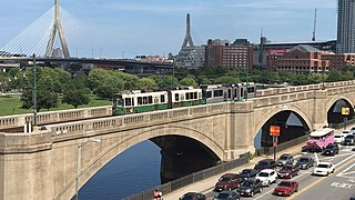
The Lechmere Viaduct is a concrete arch bridge connecting the West End neighborhood of Boston to East Cambridge, Massachusetts. Opened in 1912, the viaduct carries the MBTA's Green Line over the Charles River. It is adjacent to the Charles River Dam Bridge, but structurally separate.

The Charles River Bike Path is a mixed-use path in the Boston, Massachusetts area. It is named after the cardiologist Paul Dudley White, a prominent advocate of preventive medicine. His research led him to proclaim frequently "I'd like to put everybody on bicycles." In 1955 White served as president Eisenhower's cardiologist and prescribed his famous patient bicycle therapy after his 1955 heart attack.

Fresh Pond Parkway is an historic park and parkway, found in the westernmost neighborhoods of Cambridge, Massachusetts. The parkway was built in 1899 and added to the National Register of Historic Places in 2005.

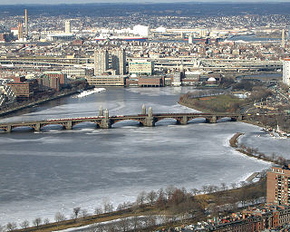
The Charles River Reservation Parkways are parkways that run along either side of the Charles River in eastern Massachusetts. The roads are contained within the Charles River Reservation and the Upper Charles River Reservation, and fall within a number of communities in the greater Boston metropolitan area. The Charles River parks extend from the Charles River Dam, where the Charles empties into Boston Harbor, to Riverdale Park in the West Roxbury neighborhood of Boston. Most of the roadways within the parks are listed on the National Register of Historic Places as a unit, although Storrow Drive and Memorial Drive are listed as part of the Charles River Basin Historic District.

The North Beacon Street Bridge is a bridge carrying North Beacon Street over the Charles River between Watertown, MA and Brighton, Boston, MA. It was built in 1917.

The Arsenal Street Bridge is a bridge connecting Arsenal Street in Watertown, Massachusetts to Western Avenue in Allston, Boston, Massachusetts. It was built in 1925 by the Commonwealth of Massachusetts Metropolitan District Commission.

The Watertown Branch Railroad was a branch loop of the Fitchburg Railroad that was meant to serve the town of Watertown and the City of Waltham, Middlesex County, Massachusetts, as an independent short line railroad; it also serviced the Watertown Arsenal. The line has been formally abandoned and portions have been converted into a rail trail, the Watertown-Cambridge Greenway. A section from School Street to Arlington Street in Watertown was completed first. A small portion in Waltham has been converted into a park called Chemistry Station Park after the railroad station once located there. Construction of an extension to Fresh Pond Reservation in Cambridge began in the summer of 2018 and was completed in June 2022.

Hemlock Gorge Reservation is a state-owned, public recreation area and urban wild comprising 23 acres (9.3 ha) on the Charles River in Newton and Needham, Massachusetts. The reservation is managed by the Massachusetts Department of Conservation and Recreation.
Bemis is a neighborhood located in the southwest corner of Watertown, Massachusetts, United States. It is bounded by Main Street to the north, the Charles River to the south, and the City of Waltham to the west. The neighborhood derives its name from Seth Bemis (1775–1851), who ran mills on both sides of the river near Bridge Street, including the Bemis Mill, which is located just across the Charles River at 1–3 Bridge Street, in Newton, and is listed on the National Register of Historic Places. Seth was the father of George Bemis, a successful lawyer and legal scholar. Bemis Park is located in this neighborhood.
Owen A. Galvin was an American attorney and politician who served as the United States Attorney for the District of Massachusetts from 1887 to 1890.
Isaac Stearns was an English emigrant who, on April 8, 1630, embarked from Yarmouth, England, aboard the ship Arbella. He was among the original settlers of the Massachusetts Bay Colony. Stearns was born c. 1598. He worked as a tailor and married Mary Barker on May 20, 1622, with whom he fathered eight children. His pedigree is unknown, and it is uncertain from where in England he came, but his wife was from the parish of Nayland, in Suffolk, and their first three children were born there.

