Flushing Charter Township is a charter township of Genesee County in the U.S. state of Michigan. The population was 10,640 at the 2010 census. Flushing Township was rated the 63rd safest community in America with a population over 10,000 by SafeWise, a home security and safety brand, in 2017.
The Salmon Falls River is a tributary of the Piscataqua River in the U.S. states of Maine and New Hampshire. It rises at Great East Lake, Newichawannock Canal, and Horn Pond and flows south-southeast for approximately 38 miles (61 km), forming the border between York County, Maine, and Strafford County, New Hampshire.
The Saco River is a river in northeastern New Hampshire and southwestern Maine in the United States. It drains a rural area of 1,703 square miles (4,410 km2) of forests and farmlands west and southwest of Portland, emptying into the Atlantic Ocean at Saco Bay, 136 miles (219 km) from its source. It supplies drinking water to roughly 250,000 people in thirty-five towns; and historically provided transportation and water power encouraging development of the cities of Biddeford and Saco and the towns of Fryeburg and Hiram. The name "Saco" comes from the Eastern Abenaki word [sɑkohki], meaning "land where the river comes out". The Jesuit Relations, ethnographic documents from the 17th century, refer to the river as Chouacoet.

The Androscoggin River is a river in the U.S. states of Maine and New Hampshire, in northern New England. It is 178 miles (286 km) long and joins the Kennebec River at Merrymeeting Bay in Maine before its water empties into the Gulf of Maine on the Atlantic Ocean. Its drainage basin is 3,530 square miles (9,100 km2) in area. The name "Androscoggin" comes from the Eastern Abenaki term /aləssíkɑntəkw/ or /alsíkɑntəkw/, meaning "river of cliff rock shelters" ; or perhaps from Penobscot /aləsstkɑtəkʷ/, meaning "river of rock shelters". The Anglicization of the Abenaki term is likely an analogical contamination with the colonial governor Edmund Andros.

Pine River may refer to any of the following streams in the U.S. state of Michigan:
- Pine River. The main branch forms with the confluence of the East and West Branches of the Pine River at 44°29′38″N83°23′16″W in Alcona County. The South Branch joins approximately 1.5 miles (2.4 km) to the south and flows into Iosco County, where it empties into Van Etten Lake at 44°29′38″N83°23′16″W northwest of Oscoda.
- Pine River. The main branch is formed by the confluence of the North and Middle Branches northeast of Standish and flows into the Saginaw Bay of Lake Huron at 43°58′32″N83°51′16″W. The South Branch Pine River joins the main stream at 43°59′08″N83°53′17″W.
- Pine River is a short waterway, which along with Round Lake, connects Lake Charlevoix with Lake Michigan at Charlevoix.
- Pine River rises in Chippewa County and flows south through Mackinac County into the St. Martin Bay of Lake Huron at 46°03′09″N84°39′22″W The North Pine River, also known as the North Branch Pine River, joins at 46°12′20″N84°36′17″W. Another tributary, Hemlock Creek, is also known as Pine River.
- Pine River, also known as the South Branch Manistee River, rises in southeast Wexford County, flows southwest across northwest Osceola County, then west and north through the northeast corner of Lake County and back into southwest Wexford County, emptying into the Tippy Dam Pond on the Manistee River at 44°13′37″N85°54′27″W. The main stream is formed from the confluence of the East Branch Pine River with the North Branch Pine River at 44°06′02″N85°31′40″W. Another tributary, the Spaulding Creek, is also known as the Little Pine River
- Pine River, in Marquette County, is a very short stream draining Pine Lake into Lake Superior at 46°53′27″N87°52′13″W, north of the Huron Mountains.
- Pine River rises in from Pine Lake in eastern Mecosta County, flows mostly south and east through Isabella County, then south along eastern edge of Montcalm County, then east and north through Gratiot County and Midland County, emptying into the Chippewa River at 43°36′06″N84°17′33″W, just about two miles before it joins the Tittabawassee River near Midland. The South Branch Pine River joins the main stream at 43°30′37″N85°00′02″W Another tributary, Miller Creek, is also sometimes known as Pine River or the West Branch Pine River. The North Branch Pine River joins the main stream at 43°26′03″N84°50′18″W.
- Pine River empties into the St. Clair River at 42°49′13″N82°29′08″W on the south side of St. Clair. The South Branch Pine River joins the main stream at 42°58′11″N82°37′10″W. Another tributary, Quakenbush Drain, is also sometimes known as Pine River.
- Pine Creek empties into Lake Superior and is also known as the Pine River.

The Cochecho River or Cocheco River is a tributary of the Piscataqua River, 38.3 miles (61.6 km) long, in the U.S. state of New Hampshire. It rises in northern Strafford County and runs southeastward, through the town of Farmington and the cities of Rochester and Dover, where it provides hydroelectric power. Below the center of Dover, the river is tidal and joins the Salmon Falls River at the Maine border to form the Piscataqua.
Tearcoat Creek is an 18.3-mile-long (29.5 km) free-flowing tributary stream of the North River, itself a tributary of the Cacapon River, making it a part of the Potomac River and Chesapeake Bay watersheds. The creek is located in central Hampshire County, West Virginia. Its name is believed to have been derived from the tearing of the coats of British soldiers by low-hanging branches as they forded the stream during either the French and Indian or the American Revolutionary Wars.
Mill Creek is a 14.5-mile-long (23.3 km) tributary of Opequon Creek, belonging to the Potomac River and Chesapeake Bay watersheds, located in Berkeley County in West Virginia's Eastern Panhandle. Its name reflects its past as a popular site for various types of mills, beginning with one constructed by Morgan Morgan in the mid-18th century near his cabin in present-day Bunker Hill.

The Gale River is a 13.1-mile (21.1 km) long tributary of the Ammonoosuc River in northwestern New Hampshire in the United States. Via the Ammonoosuc, it is part of the watershed of the Connecticut River, which flows to Long Island Sound.
Beards Brook or Beard Brook is a 12.5-mile-long (20.1 km) stream located in southern New Hampshire in the United States. It is a tributary of the North Branch of the Contoocook River, part of the Merrimack River watershed.
Mill Brook is a 10.7-mile-long (17.2 km) stream located in the White Mountains of New Hampshire in the United States. It is a tributary of the southern Swift River, part of the Bearcamp River / Ossipee Lake / Saco River watershed leading to the Atlantic Ocean.
The Shepards River is a 13.6-mile-long (21.9 km) river in western Maine and eastern New Hampshire in the United States. It is part of the Saco River drainage basin.
Walker Creek, also known as the Walker River, is a 12.0-mile-long (19.3 km) stream in Isabella County, Michigan, in the United States. It is a trout stream; the main trout species is the brook trout. The river also supports a small population of suckers. The stream is fairly small and of variable depth. Its shore is difficult to access because of the thick vegetation growing along the river. The stream rises in northwest Isabella County and flows southeast into the Lake of the Hills and the Coldwater River.

Webster Township is one of fifteen townships in Wayne County, Indiana, United States. As of the 2010 census, its population was 1,272 and it contained 552 housing units.
Buffalo Creek is a 4.1-mile-long (6.6 km) free-flowing tributary stream of the South Branch Potomac River, itself a tributary of the Potomac River, making it a part of the Chesapeake Bay watershed. Buffalo Creek is located in west-central Hampshire County in the U.S. state of West Virginia. Because the stream flows through several small farms, Buffalo Creek primarily serves agriculture purposes with segments used for livestock watering.

The Saganing River, also known as Saganing Creek, is a 10.0-mile-long (16.1 km) stream in the U.S. state of Michigan.
The Baldwin River is a 25.2-mile-long (40.6 km) stream in the U.S. state of Michigan.
Cane Hollow is a valley in Douglas County in the Ozarks of southern Missouri.
Goff Creek is a stream in Stone County in the Ozarks of southwest Missouri. It is a tributary of the James River.

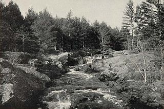
Wildcat Brook, also known as the Wildcat River, is a 9.05-mile-long (14.56 km) stream in the White Mountains of New Hampshire, in the United States. It rises at Carter Notch in the township of Bean's Purchase in Coos County, and flows south through the town of Jackson in Carroll County to its confluence with the Ellis River near the town's southern boundary. At Jackson Falls, near the town center, the stream descends 120 feet (37 m) in 1⁄4 mile (0.4 km) over scenic granite ledges, paralleled by New Hampshire Route 16B. The surrounding area is part of the Jackson Falls Historic District.