
The Mascoma River is a 31.6-mile-long (50.9 km) river in western New Hampshire in the United States. It is a tributary of the Connecticut River, which flows to Long Island Sound. The Mascoma comprises two sections which are split by Mascoma Lake in the communities of Enfield and Lebanon. Counting the lake would add 2.7 miles (4.3 km) to the river's length.
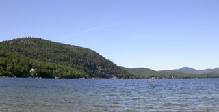
Newfound Lake is located in Grafton County, New Hampshire, United States. It is situated in the Lakes Region of central New Hampshire, in the towns of Alexandria, Bridgewater, Bristol, and Hebron. Its area of 4,451 acres (18.0 km2) places it behind only Lake Winnipesaukee and Squam Lake among lakes located entirely within New Hampshire, and fourth in the state overall, when Umbagog Lake on the Maine border is included.

Lake Wentworth is located in Carroll County in eastern New Hampshire, United States, in the town of Wolfeboro. At 3,097 acres (12.53 km2), it is the seventh-largest lake located entirely in New Hampshire. Water from Lake Wentworth flows through the short Smith River into Crescent Lake and then over the dam into Lake Winnipesaukee in Wolfeboro. The 50-acre (20 ha) Wentworth State Park offers public access to the lake.

Conway Lake is a 1,316-acre (5 km2) water body with a maximum depth of 45 feet (14 m), located in Carroll County in eastern New Hampshire, in the United States. The lake is located in the towns of Conway and Eaton, just to the east of the White Mountains, and is part of the Saco River watershed.
Merrymeeting Lake is a 1,233-acre (4.99 km2) water body located in Strafford County in eastern New Hampshire, United States, in the town of New Durham. Its outlet is the Merrymeeting River, flowing south and then northwest to Lake Winnipesaukee.
Baxter Lake is a 302.1-acre (1.223 km2) water body located in Strafford County in eastern New Hampshire, United States, in the town of Farmington and the city of Rochester. It is part of the Cocheco River watershed, a tributary of the Piscataqua River.
Canaan Street Lake is a 291-acre (118 ha) water body located in Grafton County in western New Hampshire, United States, in the town of Canaan. It is part of the Mascoma River watershed, a tributary of the Connecticut River.

Crystal Lake is a 455-acre (1.8 km2) water body located in Belknap County in the Lakes Region of central New Hampshire, United States, in the town of Gilmanton. Crystal Lake is at the head of the Suncook River watershed. Water flows into Crystal Lake from the Belknap Range through Manning and Sunset lakes to the north. Water from Manning Lake enters Crystal Lake via Nelson Brook. Other waterways flowing into Crystal Lake include Wasson Brook and Mill Brook. Water flows out of a dam from the southern end of Crystal Lake via the Suncook Lakes and Suncook River to the Merrimack River. Shoreline development along Crystal Lake consists primarily of summer cottages, with a few year-round residents. Belknap Mountain and Mount Major can be seen from the shoreline.
Crystal Lake is a 401-acre (1.6 km2) water body located in Grafton County in western New Hampshire, United States, in the town of Enfield. Crystal Lake is part of the Mascoma River watershed.

Grafton Pond is a 319-acre (1.3 km2) water body located in Grafton County in western New Hampshire, United States, in the town of Grafton. The pond is part of the Mascoma River watershed, flowing to the Connecticut River. Outflow from the pond travels through Bicknell Brook to Crystal Lake in Enfield, then north to the Mascoma River in West Canaan.

Great East Lake is an 1,825-acre (7.4 km2) water body located in Carroll County, New Hampshire, and York County, Maine, in the United States. The lake is shared by the towns of Wakefield, New Hampshire, and Acton, Maine, with 45% of its surface area in Acton and 55% in Wakefield. The lake is the farthest upstream of the five headwater lakes of the Salmon Falls River, a tributary of the Piscataqua River. Water from Great East Lake flows out its dam and through the 800-foot (240 m) Newichawannock Canal into Horn Pond, then into the Salmon Falls River below Horn Pond.

Island Pond is a 532-acre (215 ha) water body located in Rockingham County in southern New Hampshire, in the towns of Derry, Hampstead and Atkinson. The pond is at the head of the Spicket River watershed, which feeds into the Merrimack River in Lawrence, Massachusetts. The pond was formed from the merger of Perch Pond in Hampstead and Lake Wentworth in Derry in 1878, when a new dam raised the water level by 8.5 feet (2.6 m).
Mendums Pond is a 253-acre (1.02 km2) reservoir located primarily in Strafford County in eastern New Hampshire, United States, in the town of Barrington. Its extreme southern end dips into the town of Nottingham in Rockingham County. The pond is located on the Little River, a tributary of the Lamprey River and part of the larger Piscataqua River watershed.

Silver Lake is a 346-acre (1.40 km2) water body located in Cheshire County in southwestern New Hampshire, United States, in the towns of Harrisville and Nelson. Water from Silver Lake flows via Minnewawa Brook and The Branch to the Ashuelot River, a tributary of the Connecticut River.
The Suncook Lakes are a pair of lakes located in Belknap County in central New Hampshire, United States, in the town of Barnstead. Upper Suncook Lake encompasses 402 acres (1.63 km2), while Lower Suncook Lake covers 295 acres (1.19 km2). The lakes are connected by a 1,000-foot-long (300 m) channel, spanned by a road bridge. A dam at the outlet of Lower Suncook Lake controls the water level of both lakes. The lakes are located along the Suncook River, a tributary of the Merrimack River. There are three islands on Lower Lake.

Dublin Pond or Dublin Lake is a 236-acre (0.96 km2) water body located in Cheshire County in southwestern New Hampshire, United States, in the town of Dublin. The pond lies at an elevation of 1,480 feet (451 m) above sea level, near the height of land between the Connecticut River/Long Island Sound watershed to the west and the Merrimack River/Gulf of Maine watershed to the east.

Island Pond is a 179-acre (0.72 km2) water body located in Cheshire County in southwestern New Hampshire, United States, in the town of Stoddard. It is fed primarily by the outflow from Highland Lake, and its outlet is a tributary of the North Branch Contoocook River, part of the Merrimack River watershed.

Lake Sunapee is located within Sullivan County and Merrimack County in western New Hampshire, the United States. It is the fifth-largest lake located entirely in New Hampshire.
Horn Pond is a 227-acre (92 ha) water body located on the border of Acton, Maine, and Wakefield, New Hampshire, in the United States. The lake is both spring-fed and fed by the outflows of Great East Lake to the north and Wilson Lake to the east. Horn Pond's outlet is the Salmon Falls River which forms a natural border between Maine and New Hampshire and empties into the Piscataqua River east of Dover, New Hampshire, and ultimately the Gulf of Maine.
Mascoma State Forest is an area of forested land in Canaan in Grafton County, New Hampshire, on the west side of the Mascoma River. As of 2007, the tract covers 216 acres (87 ha). The forest borders the 900-acre Bear Pond Natural Area. Mascoma State Forest is managed by the state of New Hampshire Division of Forests and Lands.


