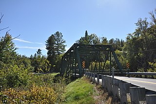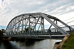
The Columbia Bridge is a covered bridge, carrying Columbia Bridge Road over the Connecticut River between Columbia, New Hampshire and Lemington, Vermont. Built in 1911–12, it is one of only two New Hampshire bridges built with Howe trusses, and is one of the last covered bridges built in the historic era of covered bridge construction in both states. It was listed on the National Register of Historic Places in 1976.

The Mount Orne Bridge is a covered bridge over the Connecticut River between Lancaster, New Hampshire, and Lunenburg, Vermont. It joins Elm Street in South Lancaster with River Road in Lunenburg. Built in 1911, it is one of two Howe truss bridges across the Connecticut River. It was listed on the National Register of Historic Places in 1976.

The Bedell Bridge was a Burr truss covered bridge that spanned the Connecticut River between Newbury, Vermont and Haverhill, New Hampshire. Until its most recent destruction in 1979, it was, with a total length of 382 feet (116 m), the second-longest covered bridge in the United States. The bridge was divided into two spans of roughly equal length, and rested on a central pier and shore abutments constructed from mortared rough stone. The eastern abutment has been shored up by the addition of a concrete footing. The bridge was 23 feet (7.0 m) wide, with a roadway width of 18.5 feet (5.6 m). Because the state line is the western low-water mark of the Connecticut River, most of the bridge was in New Hampshire; only the western abutment is in Vermont.

The Hammond Covered Bridge is a Town lattice covered bridge spanning Otter Creek in Pittsford, Vermont. The bridge was built in 1842 by Asa Norse, and originally carried Kendall Hill Road, which now passes just to its south. The bridge was added to the National Register of Historic Places on January 21, 1974.

The Butts Bridge carries Butts Bridge Road over the Quinebaug River in the town of Canterbury, Connecticut. It is a well-preserved example of a Parker truss, built in 1937, late in the state's regular use of steel truss bridge designs. The bridge is also known as Bridge No. 1649 and carries an average of 2,300 vehicles per day as of 2011. It was listed on the National Register of Historic Places in 2010.

The Samuel Morey Memorial Bridge is a historic bridge carrying New Hampshire Route 25A across the Connecticut River between Orford, New Hampshire and Fairlee, Vermont. The steel through-arch bridge was built in 1937–38 to replace an older wooden bridge which had been damaged by flooding in 1936. It spans 432 feet (132 m), stands about 35 feet (11 m) above the river, and its arches rise 85 feet (26 m) above the roadway. It rests on poured concrete abutments that have a light Art Deco or Moderne styling. Wing walls recede from the abutments into the banks in three stepped sections. Below the bridge in the river is visible some riprap, stone remnants of the old bridge's abutments and central pier. The bridge is of a "tied arch" design, in which the two arches are joined together by ties to distribute the active load. This is in contrast to the Justice Harlan Fiske Stone Bridge joining Brattleboro, Vermont and Chesterfield, New Hampshire, which was built about the same time, and distributes the active load to its abutments. The bridge components were manufactured by the American Bridge Company; construction was by Hagen-Thibodeau Construction Company at a contracted cost of just over $209,000.

The Bloomfield-Nulhegan River Route 102 Bridge is a historic bridge in Bloomfield, Vermont. It carries Vermont Route 102 over the Nulhegan River, near its mouth at the Connecticut River just south of Bloomfield Village. Built in 1937, it is a well-preserved example of a Pratt through truss, exhibiting then state-of-the-art engineering. It was listed on the National Register of Historic Places in 1991.

The Gilead Brook Bridge is a historic bridge which carries Vermont Route 12 across Gilead Brook north of the center of Bethel, Vermont. Built in 1928, it is one of four multi-span Warren deck truss bridges built in the state after extensive flooding in 1927. It was listed on the National Register of Historic Places in 1990.

The South Newfane Bridge is a historic bridge, carrying Parish Hill Road across the Rock River in the village of South Newfane, Vermont. It is a Pratt through truss span, manufactured from rolled I-beams in 1939 to replace a bridge washed away in flooding. It was listed on the National Register of Historic Places in 1992.

The Williams River Route 5 Bridge is a historic Warren deck truss bridge, carrying U.S. Route 5 (US 5) across the Williams River in Rockingham, Vermont. Built in 1929 and rebuilt in 1971-72, it is one of four bridges of this type and vintage in the state. It was listed on the National Register of Historic Places in 1991.

The South Street Bridge is a historic Pratt truss bridge, carrying Vermont Route 31 across the Poultney River just south of the village center of Poultney, Vermont. Built in 1923, it is one of a small number of surviving Pratt through trusses in the state, and one of just three that survives from the period before the state's devastating 1927 floods. It was listed on the National Register of Historic Places in 2009 as Bridge 4.

The Cold River Bridge was a historic bridge that carried Vermont Route 7B (VT 7B) across the Cold River in Clarendon, Vermont. The bridge, a steel Parker through truss, was built by the American Bridge Company in 1928, and was one of many bridges built in the state in the wake of devastating 1927 floods. It carried U.S. Route 7 (US 7) until bypassed by a bridge to the east, and was closed in 1989. It was listed on the National Register of Historic Places in 1991. It was subsequently demolished after a report noting substantial failures.

The Gould's Mill Bridge is a historic Baltimore through truss bridge, carrying Paddock Street across the Black River in Springfield, Vermont. The bridge was built by the Boston Bridge Works Company in 1929 after major flooding in 1927, and is one of the state's few examples of a Baltimore truss. It was listed on the National Register of Historic Places in 2006.

The Iron Bridge at Howard Hill Road is a modern pony truss bridge, carrying Howard Hill Road across the Black River in southeastern Cavendish, Vermont. It is a replacement for an historic 1890 Pratt through truss bridge, which is now in storage. The historic bridge was listed on the National Register of Historic Places in 1982.

The Ottauquechee River Bridge is a steel girder bridge carrying United States Route 5 across the Ottauquechee River in Hartland, Vermont. The bridge replaced a c. 1930 Warren deck truss bridge, built in the wake of Vermont's devastating 1927 floods, and listed on the National Register of Historic Places in 1990.

The Stockbridge Four Corners Bridge is a steel girder bridge carrying Vermont Route 100 across the White River near the village of Stockbridge Four Corners in Stockbridge, Vermont. The bridge is a 2009 replacement for 1929 Pratt through truss bridge, which was listed on the National Register of Historic Places in 1991. The historic bridge replaced an older covered bridge destroyed by Vermont's devastating 1927 floods.

The Winooski Street Bridge is a historic bridge carrying Winooski Street across the Winooski River between Duxbury and Waterbury, Vermont. Built in 1928, it is a Parker through truss, one of only two of this type on the Winooski River and an increasingly rare bridge type in the state. It was listed on the National Register of Historic Places in 2006 as Bridge 31.

The Mississquoi River Bridge is a steel truss bridge, spanning the Missisquoi River between Richford, Vermont and Sutton, Quebec on the Canada–United States border. It connects Chemin de la Vallée Missisquoi in Sutton with Vermont Route 105A in Richford, between the border stations of the East Richford–Glen Sutton Border Crossing. The bridge was built by the state of Vermont in 1929, and is one of two in the state built by the Pittsburgh-Des Moines Steel Company. It was listed on the United States National Register of Historic Places in 1990.

The Jeffersonville Bridge is a steel girder bridge carrying Vermont Route 108 across the Lamoille River, just north of the village of Jeffersonville, Vermont. It was built in 2014, replacing a Parker through truss bridge built in 1931; the latter bridge was listed on the National Register of Historic Places in 1991.

The Lyme–East Thetford Bridge is a historic bridge over the Connecticut River between Lyme, New Hampshire, and East Thetford, Vermont. From the New Hampshire side it carries East Thetford Road, which becomes Vermont Route 113 as it enters Vermont. A Parker truss bridge completed in 1937, it is 471 feet (144 m) long. The bridge was added to the National Register of Historic Places in 2020.


