
Turners Falls is an unincorporated village and census-designated place in the town of Montague in Franklin County, Massachusetts, United States. The population was 4,512 at the 2020 census. It is part of the Springfield, Massachusetts Metropolitan Statistical Area. Its name is often used as a metonym for the entire town of Montague, for which it is the business district and comprises more than half the population.

The Minuteman Bikeway, also known as the Minuteman Commuter Bikeway, is a 10-mile (16-kilometre) paved multi-use rail trail located in the Greater Boston area of Massachusetts. It runs from Bedford to Alewife station, at the northern end of the Red Line in Cambridge, passing through the towns of Lexington and Arlington along the way. Also along the route are several notable regional sites, including Alewife Brook Reservation, the Cyrus Dallin Art Museum, Spy Pond, "Arlington’s Great Meadows", the Battle Green in Lexington, and Hanscom Air Force Base.

Deerfield River is a river that runs for 76 miles (122 km) from southern Vermont through northwestern Massachusetts to the Connecticut River. The Deerfield River was historically influential in the settlement of western Franklin County, Massachusetts, and its namesake town. It is the Connecticut River's second-longest tributary in Massachusetts, 2.1 miles (3.4 km) shorter than Metropolitan Springfield's Westfield River.

The Mass Central Rail Trail (MCRT) is a partially completed rail trail between Northampton, Massachusetts and Boston along the right-of-way (ROW) of the former Massachusetts Central Railroad and former Central Massachusetts Railroad. It currently has over 60 miles (97 km) open, and 94.5 miles (152.1 km) are open or protected for trail development. When complete, it will be 104 miles (167 km) long through Central Massachusetts and Greater Boston, forming the longest rail trail in New England. Many sections of the trail, including the Norwottuck Branch of the Mass Central Rail Trail and the Somerville Community Path, have been developed as separate projects but serve as part of the complete Mass Central Rail Trail. The Norwottuck Network, a 501(c)(3) nonprofit that supports the build and operation of the MCRT, maintains an interactive map of the MCRT and other Massachusetts trails.

The Huey P. Long Bridge, located in Jefferson Parish, Louisiana, is a cantilevered steel through-truss bridge that carries a two-track railroad line over the Mississippi River at mile 106.1, with three lanes of US 90 on each side of the central tracks. It is several kilometers upriver from the city of New Orleans. The East Bank entrance is at Elmwood, Louisiana, and the West Bank at Bridge City.

Air Line State Park Trail is a rail trail and linear state park located in Connecticut. The trail is divided into sections designated South, North a piece of the East Coast Greenway, and the Thompson addition. An additional 3.6-mile spur to Colchester is sometimes designated as part of the Air Line trail. At the Massachusetts state line, the trail connects to the Southern New England Trunkline Trail, a 22-mile-long trail to Franklin, MA built on the same right-of-way. Since 2018, the town of Portland, Connecticut has also maintained a 2.3-mile portion of the Air Line trail, connecting to the southern end of the state park at the town line with East Hampton.

The Cape Cod Rail Trail (CCRT) is a 25.5-mile (41.0 km) paved rail trail located on Cape Cod in Massachusetts. The trail route passes through the towns of Yarmouth, Dennis, Harwich, Brewster, Orleans, Eastham, and Wellfleet. It connects to the 6-plus mile (10 km) Old Colony Rail Trail leading to Chatham, the 2 mile Yarmouth multi-use trail, and 8 miles (13 km) of trails within Nickerson State Park. Short side trips on roads lead to national seashore beaches including Coast Guard Beach at the end of the Nauset Bike Trail in Cape Cod National Seashore. The trail is part of the Claire Saltonstall Bikeway.
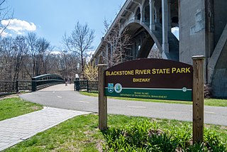
The Blackstone River Greenway is a partially completed 48-mile (77 km) paved rail trail defining the course of the East Coast Greenway through the Blackstone Valley from Worcester, Massachusetts to Providence, Rhode Island in the United States.

The Norwottuck Rail Trail Bridge is a former crossing of Boston and Maine Railroad over the Connecticut River in western Massachusetts, connecting the towns of Northampton and Hadley, by the Norwottuck Rail Trail, which is currently used for bicycle and foot traffic.

The Sunderland Bridge is a crossing over the Connecticut River in western Massachusetts, connecting the towns of South Deerfield and Sunderland, carrying Massachusetts Route 116.

The Hampden County Memorial Bridge is a reinforced-concrete arch bridge that spans the Connecticut River between Springfield, Massachusetts and West Springfield, Massachusetts, constructed in 1922. The bridge is owned by Massachusetts Highway Department. It spans 209 feet (64 m) and rises 29.71 feet (9.06 m) above the river.

The Schell Memorial Bridge is a steel cantilever Pennsylvania (Petit) truss bridge spanning the Connecticut River in the town of Northfield, Massachusetts. Designed by Edward S. Shaw, the bridge abutments and piers were built by the firm of Ellis & Buswell of Woburn, Massachusetts, and the superstructure was built by the New England Structural Company of East Everett, Massachusetts. The bridge was commissioned by Francis R. Schell, who gave $42,000 for design and construction. Construction began in 1901 and was completed in 1903. In 1985, due to advanced deterioration of the steel truss members, the bridge was barricaded and abandoned.

The Norwottuck Branch Rail Trail, full name the Norwottuck Branch of the Mass Central Rail Trail, formerly the Norwottuck Rail Trail, is an 11-mile (18 km) combination bicycle/pedestrian paved rail trail running from Northampton, Massachusetts, through Hadley and Amherst, to Belchertown, Massachusetts. It opened in 1993, and is now part of the longer Mass Central Rail Trail.

The General Pierce Bridge is a steel truss road bridge over the Connecticut River between Greenfield, Massachusetts and Montague, Massachusetts carrying Montague City Road.

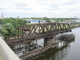
A three-span deck-truss railroad bridge crosses the Connecticut River between Deerfield and Montague in Franklin County, Massachusetts.

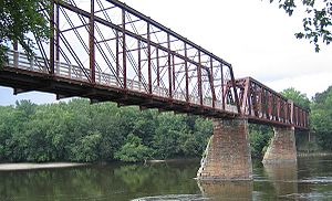
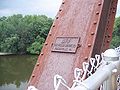
The Canalside Rail Trail is a 3.8-mile (6.1 km) trail, partially on old railroad beds, from East Deerfield to Turners Falls in Montague, Massachusetts, US. A short portion of the trail runs along town streets, but the majority is on a paved trail from which motor vehicles are prohibited. The northern terminus is Unity Park, on Barton's Cove in Turners Falls. The southernmost portion crosses the Connecticut River on the Canalside Rail Trail Bridge and ends at McClelland Farm Road in Deerfield. The trail was completed in spring 2008.

The Linden Street Bridge is an abandoned Central Massachusetts Railroad bridge over Linden Street in Waltham, Massachusetts. A restoration of the bridge is under construction as a part of the Mass Central Rail Trail—Wayside (MCRT—Wayside) project. It is a riveted lattice through truss bridge, built in 1894 by the Pennsylvania Steel Company, and is one of only three such bridges left in the state. The bridge is 98 feet 3 inches (29.95 m) long and 17 feet (5.2 m) wide, with an inside truss height of 21 feet 11.5 inches (6.693 m), and rests on granite abutments. The design of the bridge was based on that of the Northampton crossing of the Connecticut River by the same railroad.
Philadelphia, Wilmington and Baltimore Railroad Bridge No. 1 was a swing steel through truss that spanned the Schuylkill River between Philadelphia, Pennsylvania's Kingsessing and Grays Ferry neighborhoods.

The James D. Pfluger Pedestrian and Bicycle Bridge is a shared use bridge for pedestrians and cyclists spanning Lady Bird Lake in downtown Austin, Texas. Opened in 2001, the bridge connects the north and south sides of the Ann and Roy Butler Hike-and-Bike Trail and features an unusual "double curve" design. The bridge runs parallel to the Lamar Boulevard Bridge, which carries road traffic across the lake roughly 200 feet (61 m) to the west.
The Turners Falls branch was a railway line in Franklin County, Massachusetts, in the United States. It ran 9 miles (14 km) from a junction with the Shelburne Falls Extension at South Deerfield, Massachusetts, to Turners Falls, Massachusetts. It was originally built in 1868 by the New Haven and Northampton Railroad, later part of the New York, New Haven and Hartford Railroad. The Boston and Maine Railroad, which had its own branch to Turners Falls, acquired the Turners Falls branch from the New Haven in 1947 and abandoned its own line. The B&M subsequently abandoned the branch in 1985. Part of it is now the Canalside Rail Trail.


