Hamlin Peak

Last updated
Hamlin Peak
Hamlin Peak seen from Baxter Peak.jpg
Highest point
Elevation 4,756 ft (1,450 m)
Prominence 496 ft (151 m) [1]
Listing New England 4000 footers
Coordinates 45°55′16″N68°55′24″W / 45.921167°N 68.923333°W / 45.921167; -68.923333 Coordinates: 45°55′16″N68°55′24″W / 45.921167°N 68.923333°W / 45.921167; -68.923333 [2]
Geography
Topo map USGS Mount Katahdin
Climbing
Easiest route Hike

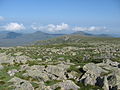
Hamlin Peak is a 4,756-foot (1,450 m) mountain located in Baxter State Park in Piscataquis County, Maine. [3] Hamlin Peak is a northern spur of the greater Mount Katahdin massif and is flanked to the south by Baxter Peak, and to the north by the Howe Peaks. Since it rises nearly 500 feet (150 m) above the col joining it to the higher Baxter Peak, Hamlin Peak qualifies as a four-thousand footer based on the topographic prominence criterion used by the Appalachian Mountain Club, and is ranked as the second-highest peak in Maine.

Mountain A large landform that rises fairly steeply above the surrounding land over a limited area

A mountain is a large landform that rises above the surrounding land in a limited area, usually in the form of a peak. A mountain is generally steeper than a hill. Mountains are formed through tectonic forces or volcanism. These forces can locally raise the surface of the earth. Mountains erode slowly through the action of rivers, weather conditions, and glaciers. A few mountains are isolated summits, but most occur in huge mountain ranges.

Baxter State Park state park

Baxter State Park is a large wilderness area permanently preserved as a state park, located in Northeast Piscataquis, Piscataquis County in north-central Maine, United States. It is in the North Maine Woods region, and the Katahdin Woods and Waters National Monument borders Baxter State Park.

Piscataquis County, Maine County in the United States

Piscataquis County is a county located in the U.S. state of Maine. As of the 2010 census, its population was 17,535, making it Maine's least-populous county. Its county seat is Dover-Foxcroft. The county was incorporated on 23 March 1838, taken from the western part of Penobscot County and the eastern part of Somerset County, and is named for an Abenaki word meaning "branch of the river" or "at the river branch."

Contents

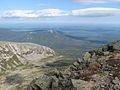
The southeast face of Hamlin Peak drains into the Great Basin, where water ultimately flows into the Penobscot River and eventually empties into the Atlantic Ocean at Penobscot Bay.

Penobscot River river in the US state of Maine

The Penobscot River is a 109-mile-long (175 km) river in the U.S. state of Maine. Including the river's West Branch and South Branch increases the Penobscot's length to 264 miles (425 km), making it the second-longest river system in Maine and the longest entirely in the state. Its drainage basin contains 8,610 square miles (22,300 km2).

Atlantic Ocean Ocean between Europe, Africa and the Americas

The Atlantic Ocean is the second largest of the world's oceans, with an area of about 106,460,000 square kilometers. It covers approximately 20 percent of the Earth's surface and about 29 percent of its water surface area. It separates the "Old World" from the "New World".

Penobscot Bay Bay in Maine, United States

Penobscot Bay is an inlet of the Gulf of Maine and Atlantic Ocean in south central Maine. The bay originates from the mouth of Maine's Penobscot River, downriver from Belfast. Penobscot Bay has many working waterfronts including Rockland, Rockport, and Stonington, and Belfast upriver. Penobscot Bay is between Muscongus Bay and Blue Hill Bay, just west of Acadia National Park.

There are several trails that lead to or near the summit of Hamlin Peak. [4] [5]

See also

Related Research Articles

Mount Chase, Maine Town in Maine, United States

Mount Chase is a town in Penobscot County, Maine, United States. The population was 201 at the 2010 census.

Mount Katahdin highest mountain in the US state of Maine

Mount Katahdin is the highest mountain in the U.S. state of Maine at 5,267 feet (1,605 m). Named Katahdin by the Penobscot Native Americans, which means "The Greatest Mountain", it is located within Northeast Piscataquis, Piscataquis County, and is the centerpiece of Baxter State Park. It is a steep, tall masiff formed from a granite intrusion weathered to the surface. The flora and fauna on the mountain are typical of those found in northern New England.

Percival Proctor Baxter American politician

Percival Proctor Baxter was the 53rd Governor of the U.S. state of Maine who served from 1921 to 1925.

Mount Baxter may refer to:

Four-thousand footers are a group of forty-eight mountains in New Hampshire at least 4,000 feet (1,200 m) above sea level. To qualify for inclusion a peak must also meet the more technical criterion of topographic prominence important in the mountaineering sport of peak-bagging.

Pamola is a legendary bird spirit that appears in Abenaki mythology. This spirit causes cold weather.

Crocker Mountain (Maine) mountain in United States of America

Crocker Mountain is a 4,228 ft (1,289 m) peak located in Carrabassett Valley, Franklin County, Maine, in the United States. Crocker Mountain is the fourth highest mountain in the state after the Katahdins and Sugarloaf Mountain, and is part of the Appalachian Mountains. Crocker Mountain is traversed by the Appalachian Trail (AT), a 2,170 mi (3,490 km) National Scenic Trail from Georgia to Maine.

Sugarloaf Mountain (Franklin County, Maine) mountain located in Franklin County, Maine

Sugarloaf Mountain is a ski mountain located in Carrabassett Valley, Franklin County, Maine. It is the third highest peak in the state, after Mount Katahdin's Baxter and Hamlin peaks. Sugarloaf is flanked to the south by Spaulding Mountain.

North Brother mountain in United States of America

North Brother is a mountain located in Baxter State Park, Piscataquis County, Maine. North Brother is flanked to the northeast by Fort Mountain, and to the southwest by South Brother; collectively the two are called "The Brothers."

South Brother mountain in United States of America

South Brother is a mountain located in Piscataquis County, Maine, in Baxter State Park. South Brother is flanked to the southwest by Mount Coe, and to the northeast by North Brother; collectively the two are called "The Brothers".

Traveler Mountain mountain in United States of America

Traveler Mountain is a mountain located in Piscataquis County, Maine, in Baxter State Park. The Traveler, is the eighth-most prominent in Maine. Subsidiary peaks include the Peak of the Ridges 3,225 ft (983 m) North and South Traveler Mountain 3,144 ft (958 m) and 2,677 ft (816 m), respectively.

Doubletop Mountain (Maine) mountain in United States of America

Doubletop Mountain is a mountain located in Piscataquis County, Maine, in Baxter State Park. As the name implies, the mountain has two peaks; a north peak and a south peak. From the north a trail from the Nesowednehunk Campground to the north peak is 3.1 miles (5.0 km) long and another 0.2 miles (0.32 km) to the south peak. From Foster Field, to the south, a 4-mile (6.4 km) trail leads to the summit. The last third of mile (0.53 km) is steep and climbs about 900 feet (270 m). The north peak is wooded while the south peak is more open.

Fort Mountain (Maine) mountain in Maine, United States of America

Fort Mountain is a mountain located in Piscataquis County, Maine, within Baxter State Park. Fort Mountain is flanked to the southeast by North Brother Mountain, and to the north by Mullen Mountain. Although officially trailless, a well-defined herd path leads to the summit of Fort from North Brother.

Mount Coe mountain in United States of America

Mount Coe is a mountain located in Piscataquis County, Maine, within Baxter State Park, about 5.5 mi (9 km) northwest of Mount Katahdin. Mt. Coe is flanked to the northeast by South Brother, and to the southwest by Mount O-J-I. The Mount Coe trail starts at Slide Dam on Newsowdnehunk Stream east bank at around 1,190 ft (360 m). The trail goes up to the east for about 1.2 mi (1.9 km) and then goes right (south) along the drainage from the Mt. Coe slide bending to the east and then northeast. The last 0.5 mi (0.80 km) is up the slide featured on the left margin of the photo where the trail gains around 800 ft (240 m).

Pemadumcook Chain of Lakes

The Pemadumcook Chain of Lakes are a set of large lakes in north-central Maine in the United States.

West Branch Penobscot River river in the United States of America

The West Branch Penobscot River is a 117-mile-long (188 km) tributary of the Penobscot River through the North Maine Woods in Maine. The river is also known as Abocadneticook, Kahgognamock, and Kettegwewick.

Great Northern Paper Company


Great Northern Paper Company was a Maine-based pulp and paper manufacturer that at its peak in the 1970s and 1980s operated mills in Arkansas, Georgia, Maine, and Wisconsin and produced 16.4% of the newsprint made in the United States.

Katahdin Woods and Waters National Monument protected area in Maine, US

Katahdin Woods and Waters National Monument is a U.S. National Monument spanning 87,563 acres (35,435 ha) of mountains and forestland in northern Penobscot County, Maine, including a section of the East Branch Penobscot River. The monument is located on the eastern border of Maine's Baxter State Park.

Maine State Route 157

State Route 157 (SR 157) is a 22-mile-long (35 km) state highway in the northern part of the U.S. state of Maine. It travels between the towns of Millinocket and Mattawamkeag generally following the northern banks of the West Branch Penobscot River and the Penobscot River. For just under a half of its length, it is concurrent with SR 11 from Millinocket to Medway. This portion is also concurrent with the Katahdin Woods & Waters Maine Scenic Byway.

References