Mount Katahdin is the highest mountain in the U.S. state of Maine at 5,269 feet (1,606 m). Named Katahdin, which means "Great Mountain", by the Penobscot Native Americans, it is within Northeast Piscataquis, Piscataquis County, and is the centerpiece of Baxter State Park. It is a steep, tall massif formed from a granite intrusion weathered to the surface. The flora and fauna on the mountain are typical of those found in northern New England, with the summit hosting fragile and endangered alpine tundra.

Cascade Mountain is in Essex County of New York. It is one of the 46 Adirondack High Peaks (36th) and is located in the Adirondack Park. Its name comes from a series of waterfalls on a brook near the mountain's base. The lake it flows into and the pass between Cascade and Pitchoff mountains are also named Cascade.

Porter Mountain is one of the Adirondack High Peaks. It is number 38 in order of height, and one of the easier hikes of the Adirondack Forty-Sixers. It is named after Noah Porter, one of the first to climb it, later president of Yale University.

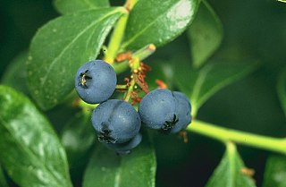
Vaccinium angustifolium, commonly known as the wild lowbush blueberry, is a species of blueberry native to eastern and central Canada and the northeastern United States. It is the most common commercially used wild blueberry and is considered the "low sweet" berry.

Glencliff is an unincorporated community within the White Mountain National Forest in the town of Warren in Grafton County, New Hampshire, United States. The village consists of fewer than one hundred residents and some forty man-made structures, including the Willing Workers Hall, the Glencliff Community Chapel, the old firefighter's garage, the Glencliff Improvement Cooperative, the post office and the Glencliff Home for the Elderly.

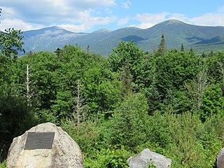
Mount Carrigain is a mountain located in Grafton County, New Hampshire. The mountain is named after Phillip Carrigain, NH Secretary of State (1805–10), and is on the south side of the Pemigewasset Wilderness, the source of the East Branch of the Pemigewasset River in the heart of the White Mountains, between Franconia Notch and Crawford Notch. Carrigain is flanked to the northeast beyond Carrigain's Vose Spur by Mount Anderson and Mount Lowell across Carrigain Notch, and to the southwest by Mount Hancock. It has a fire tower at the summit, providing 360 degree views of the surrounding wilderness.

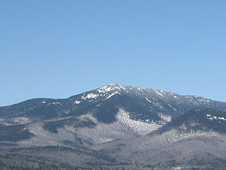
Crocker Mountain is a 4,228 ft (1,289 m) peak located in Carrabassett Valley, Franklin County, Maine, in the United States. Crocker Mountain is the fourth highest mountain in the state after the Katahdins and Sugarloaf Mountain, and is part of the Appalachian Mountains. Crocker Mountain is traversed by the Appalachian Trail (AT), a 2,170 mi (3,490 km) National Scenic Trail from Georgia to Maine.

Mount Bigelow is a long mountain ridge with several summits. It is located in Franklin County and Somerset County, Maine. It is one of Maine's highest summits. The mountain is named after Major Timothy Bigelow who climbed the rugged summit in late October 1775 "for the purpose of observation." Major Bigelow was one of Colonel Benedict Arnold's four division commanders during the 1775 Invasion of Canada. The expeditionary force passed along the Dead River on the northern edge of the Bigelow Range, now dammed into Flagstaff Lake.

Sugarloaf Mountain is a ski mountain located in Carrabassett Valley, Franklin County, Maine. It is the third highest peak in the state, after Mount Katahdin's Baxter and Hamlin peaks. Sugarloaf is flanked to the south by Spaulding Mountain.
Mount Franklin is a mountain in Coös County, New Hampshire, United States. The mountain is named after Benjamin Franklin and is part of the Presidential Range of the White Mountains. Note that Ben Franklin was not a president. Mount Franklin is flanked to the northeast by Mount Monroe, and to the southwest by Mount Eisenhower.
Mount Whiteface is a 4,019 ft (1,225 m) mountain located in Grafton County, New Hampshire. The mountain is part of the Sandwich Range of the White Mountains. Whiteface is flanked to the northwest by Mount Tripyramid, and to the northeast by Mount Passaconaway. Whiteface is on the eastern border of the Sandwich Range Wilderness. To the east, between Whiteface, Passaconaway, and Mt. Wonalancet, lies The Bowl natural area, an unlogged cirque.

Old Speck Mountain, also known as Old Speckle Mountain, is a mountain located in Oxford County, Maine, United States. The mountain, the fourth-highest in the state, is the northeasternmost and highest of the Mahoosuc Range, the northeasternmost part of the White Mountains. Old Speck is flanked to the southwest by Mahoosuc Arm, and faces Baldpate Mountain to the northeast across Grafton Notch.

Mount Redington is a mountain located in Franklin County, Maine. Redington is flanked to the northeast by South Crocker Mountain and to the west by Black Nubble. Redington stands just northeast of the U.S. Navy Survival Escape and Evasion Training Facility (USSEAETF).

Rocky Peak Ridge is a mountain in the Adirondacks in the U.S. state of New York. It is the 20th-highest of the Adirondack High Peaks, with an elevation of 4,420 feet (1,350 m). It is located in the Giant Mountain Wilderness Area, in the town of Keene in Essex County. The mountain is named for its appearance as a rocky ridge to the east of the better-known Giant Mountain. Other early names for the mountain included "Giant's Wife", "Bald Mountain", and "Bald Peak", the last of which now belongs to a shorter nearby peak. The earliest recorded ascent of the mountain was made by trail guides Fred J. Patterson and Sam Dunning in 1878. A major forest fire in 1903 burned the topsoil from the top of the mountain and left it with its distinctive bare ridge.
Gap Mountain, located in Troy, New Hampshire, United States, is a small monadnock with three summits ranging between 1,820 feet (555 m) and 1,900 feet (579 m) above sea level. The lower north and middle summits are mostly bald and offer panoramic views of the surrounding rural landscape and of the higher and more popular Mount Monadnock. The Metacomet-Monadnock Trail passes over the north and middle peaks. The higher southern summit is wooded with no views. The mountain, located entirely within the Gap Mountain Reservation managed by the Society for the Protection of New Hampshire Forests, is named for the cleft separating the south peak from the north and middle summits.
Blueberries are a widely distributed and widespread group of perennial flowering plants with blue or purple berries. They are classified in the section Cyanococcus within the genus Vaccinium. Commercial blueberries—both wild (lowbush) and cultivated (highbush)—are all native to North America. The highbush varieties were introduced into Europe during the 1930s.
The South Branch Sandy River is a short tributary of the Sandy River in Franklin County, Maine. From its source on Blueberry Mountain in Berlin, the river runs 7.4 miles (11.9 km) northeast to its confluence with the Sandy River in Phillips.
Speckled Mountain is a mountain located in western Maine. It can be ascended by the Bickford Brook, Spruce Hill, Cold Brook, Red Rock and Blueberry Ridge trails, and is a popular day hike. It is a part of the Caribou-Speckled Mountain Wilderness within the White Mountain National Forest. It is located near the AMC Cold River Camp.

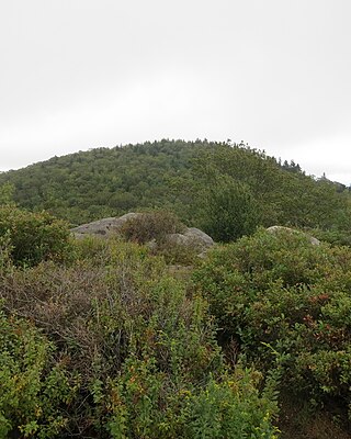
Black Cap Mountain is a 1,020 foot (310 m) mountain in Penobscot County, Maine, United States. The mountain is 5 miles (8.0 km) southeast of Eddington, Maine, and the Penobscot River. It is accessible from Maine Route 46, near its intersection with The Airline.

Lead Mountain, at 1,479-foot (451 m) high is a peak in eastern Maine. Lead Mountain is located north of the town of Beddington on the border of Hancock and Washington counties in Downeast Maine. The isolation of Lead Mountain is 35.73 miles, and it is easily visible from miles away along Maine state routes 9 and 193