Mars Hill is a town in Aroostook County, Maine, United States, nestled at the foot of Mars Hill Mountain. The town borders Wicklow Parish, New Brunswick, Canada. The region is mainly agricultural. The population was 1,360 at the time of the 2020 census.

Equinox Mountain is the highest peak of the Taconic Range and the second-highest point in southern Vermont, after Stratton Mountain. It rises nearly 3,000 feet above its eastern footings in Manchester, giving Equinox the third-greatest topographic prominence among the state's mountains. A summit observation building is reached via a privately operated toll road, which passes near various towers used for broadcast and other purposes.

The Dagenham wind turbines are two 85-metre (279 ft) high Enercon E-66 and one E-82 wind turbines located on the Dagenham estate of the Ford Motor Company in East London, England. The first two turbines were completed in April 2004 and the third was installed in 2011. They are landmarks of the skyline and the first wind farm to be built in London.

The San Gorgonio Pass wind farm is a wind farm that stretches from the eastern slope of the San Gorgonio Pass, near Cabazon, to North Palm Springs, on the western end of the Coachella Valley, in Riverside County, California. Flanked by Mount San Gorgonio and the Transverse Ranges to the North, and Mount San Jacinto and the Peninsular Ranges to the South, the San Gorgonio Pass is a transitional zone from a Mediterranean climate west of the pass, to a Desert climate east of the pass. This makes the pass area one of the most consistently windy places in the United States.

Hoosac Wind Power Project is a wind farm on Crum Hill in Monroe, Massachusetts and on Bakke Mountain in Florida, Massachusetts. Owned and operated by Iberdrola Renewables, it is the largest wind farm in Massachusetts, with 19 GE 1.5 MW wind turbines and a total installed capacity of 28.5 MW. The Hoosac Wind power project became fully operational in 2012 and provides enough electricity to power 10,000 homes annually.

The Mendota Hills Wind Farm is a wind farm in Lee County, Illinois near the village of Paw Paw. It operates 29 wind turbines. Each wind turbine stands 214 ft tall and has three 85 ft long blades. The wind farm was constructed from June 2003 to November 24, 2003. Mendota Hills was the first utility-scale wind farm in the state of Illinois.
Wind power in Ohio has a long history. As of 2016, Ohio had 545 megawatts (MW) of utility-scale wind power installations, responsible for generating 1.1% of the state's electricity. Over 1000 MW more were under construction or pending approval. Some installations have become tourist attractions. There has been a sudden increase in generating capacity, as the total wind power capacity in the state was just 9.7 MW in 2010. By 2019, there were 738 MW of capacity, which generated 1.71% of Ohio's electricity.

Biglow Canyon Wind Farm is an electricity generating wind farm facility in Sherman County, Oregon, United States. It is owned by Portland, Oregon-based Portland General Electric and began operations in 2007. With the completion of phase 3 of the project it has a generating capacity of 450 megawatts. It is located roughly five miles (8 km) northeast of Wasco, Oregon, and about ten miles (16 km) southeast of Rufus, Oregon. Biglow Canyon Wind Farm covers 25,000 acres (10,000 ha) in the Columbia River Gorge.
Stetson Mountain is a small mountain located in Washington County, Maine; a 8-mile (13 km) long ridge running roughly north–south. The summit elevation is between 1,080 ft (330 m) and 1,090 ft (330 m). Stetson is approximately 10 miles (16 km) from the Canada–United States border with New Brunswick.

Kibby Wind Power Project is a wind farm on Kibby Mountain in Franklin County, Maine, United States of America.
There are a number of wind power projects in the state of Maine, totaling more than 900 megawatts (MW) in capacity. In 2020 they were responsible for 24% of in-state electricity production. In 2019, Maine had more wind capacity than the other five New England states combined, at 923 MW.
A wind turbine is a device that converts the kinetic energy of wind into electrical energy. As of 2020, hundreds of thousands of large turbines, in installations known as wind farms, were generating over 650 gigawatts of power, with 60 GW added each year. Wind turbines are an increasingly important source of intermittent renewable energy, and are used in many countries to lower energy costs and reduce reliance on fossil fuels. One study claimed that, as of 2009, wind had the "lowest relative greenhouse gas emissions, the least water consumption demands and the most favorable social impacts" compared to photovoltaic, hydro, geothermal, coal and gas energy sources.

Coopers Gap Wind Farm is a 453 megawatt wind farm in the Western Downs and South Burnett regions of Queensland, Australia. It is located approximately 175 km north-west of the state capital Brisbane, and 50 kilometres south-west of Kingaroy and 65 kilometers north of Dalby. When construction was announced to be completed on 30 April 2020, it became the largest wind farm in Australia. This record was held until 10 December 2020 when the Stockyard Hill Wind Farm in Victoria was completed.

Starting in 1975, NASA managed a program for the United States Department of Energy and the United States Department of Interior to develop utility-scale wind turbines for electric power, in response to the increase in oil prices. A number of the world's largest wind turbines were developed and tested under this pioneering program. The program was an attempt to leap well beyond the then-current state of the art of wind turbine generators, and developed a number of technologies later adopted by the wind turbine industry. The development of the commercial industry however was delayed by a significant decrease in competing energy prices during the 1980s.
Mut Wind Farm is a wind power plant consisting of eleven wind turbines situated on Mt. Magras in Özlü in the Mut district of Mersin Province in southern Turkey. The wind farm went into service in 2010.
Soma Wind Farm is an onshore wind power plant in Soma in Manisa Province in the northwestern Aegean Region of Turkey. Built in two phases and consisting of 119 wind turbines with an installed output power of 140 MW in total, it is one of Turkey's largest wind farms.
Bahçe Wind Farm or Gökçedağ Wind Farm is an onshore wind power plant in the Bahçe district of Osmaniye Province, in the eastern Mediterranean Region of Turkey. Consisting of 54 wind turbines with an installed output power of 135 MW in total, the wind farm was the country's largest one when it was commissioned in 2009.
The Berkshire Wind Power Project is a wind farm on Brodie Mountain in Hancock, Massachusetts. Owned and operated by the Berkshire Wind Power Cooperative Corporation, it is the second largest wind farm in Massachusetts, with 12 GE 1.5 MW wind turbines and a total installed capacity of 19.6 MW. The Berkshire wind power project became fully operational in 2011, and provides enough electricity to power 7,800 homes annually.

The Pollupalai and Vallimunai Wind Farms are two wind farms built together by Joule Power and Beta Power, on the north-eastern shore of the Jaffna Lagoon, in Pachchilaipalli, Sri Lanka. Both wind farms are owned by the parent company WindForce, and have an installed capacity of 12 megawatts each, and an annual production of approximately 60 GWh. The wind farms are the first-ever to be constructed in the Northern Province of Sri Lanka.

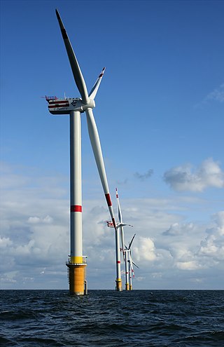
The VolturnUS is a floating concrete structure that supports a wind turbine, designed by University of Maine Advanced Structures and Composites Center and deployed by DeepCwind Consortium in 2013. The VolturnUS can support wind turbines in water depths of 150 ft (46 m) or more. The DeepCwind Consortium and its partners deployed a 1:8 scale VolturnUS in 2013. Efforts are now underway by Maine Aqua Ventus 1, GP, LLC, to deploy to full-scale VolturnUS structures off the coast of Monhegan Island, Maine, in the UMaine Deepwater Offshore Wind Test Site. This demonstration project, known as New England Aqua Ventus I, is planned to deploy two 6 MW wind turbines by 2020.