Jefferson County (Jeffco) is one of the 64 counties in the U.S. state of Colorado. As of the 2010 census, the population was 534,543, making it the fourth-most populous county in Colorado. The county seat is Golden, and the most populous city is Lakewood.

Jefferson is a town in Coos County, New Hampshire, United States. The population was 1,107 at the 2010 census. It is home to parts of the White Mountain National Forest in the south and northeast and to two theme parks: Santa's Village and Fort Jefferson Fun Park. There are also several private campgrounds, motels and inns.

The Presidential Range is a mountain range located in the White Mountains of the U.S. state of New Hampshire. Containing the highest peaks of the Whites, its most notable summits are named for American presidents, followed by prominent public figures of the 18th and 19th centuries. The Presidential Range is notorious for having some of the worst weather on Earth, mainly because of the unpredictability of high wind speeds and whiteout conditions on the higher summits. Because of the poor weather conditions, the Presidential Range is often used for mountaineering training for those who go on to climb some of the world's highest mountains, including K2 and Everest.

Mount Jefferson is a stratovolcano in the Cascade Volcanic Arc, part of the Cascade Range in the U.S. state of Oregon. The second highest mountain in Oregon, it is situated within Linn County, Jefferson County, and Marion County and forms part of the Mount Jefferson Wilderness. Due to the ruggedness of its surroundings, the mountain is one of the hardest volcanoes to reach in the Cascades. It is also a popular tourist destination despite its remoteness, with recreational activities including hiking, backpacking, mountaineering, and photography. Vegetation at Mount Jefferson is dominated by Douglas-fir, silver fir, mountain hemlock, ponderosa pine, lodgepole pine, and several cedar species. Carnivores, insectivores, bats, rodents, deer, birds, and various other species inhabit the area.

Mount Jefferson State Natural Area is a 1,086-acre (4.39 km2) North Carolina state park in Ashe County, North Carolina in the United States. Located near Jefferson, North Carolina, it includes the peak of Mount Jefferson, named for Thomas Jefferson and his father Peter, who owned land nearby and surveyed the North Carolina-Virginia border in 1749. In 1974, Mount Jefferson State Natural Area was designated as a National Natural Landmark by the National Park Service.

Mount Jefferson is a mountain located on the Continental Divide between Fremont County of northeastern Idaho and Beaverhead County of southwestern Montana. Mount Jefferson is the highest point of the Centennial Mountains, whose crest runs along the Continental Divide and can be climbed using a class 2 route (scramble) from the access road to neighboring Sawtell Peak.
Mount Jefferson is a mountain located in Ashe County, North Carolina. The mountain is part of the Mount Jefferson State Natural Area. The mountain has an elevation of 4,665 feet (1,422 m) above sea level, and it sharply rises more than 1,600 feet above the towns of Jefferson, North Carolina and West Jefferson.

Mount Jefferson is located in Coos County, New Hampshire, and is the third highest mountain in the state. The mountain is named after Thomas Jefferson, the third president of the United States, and is part of the Presidential Range of the White Mountains. Mount Jefferson is flanked by Mount Adams and Mount Clay.
Mount Jefferson is a mountain located in Schoharie County of New York. Mount Jefferson is the source of three major rivers, Hudson, Delaware, and Susquehanna.

Mount Jefferson is a mountain located just outside Charlottesville, Virginia, United States, in Albemarle County. It lies south of Lewis Mountain, and is positioned at the northeastern edge of the Ragged Mountains.
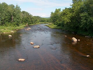
The Israel River, sometimes referred to as Israel's River, is a river in the White Mountains of New Hampshire, in the United States. It rises in the township of Low and Burbank's Grant and runs 24 miles (39 km) generally northwest along U.S. Highway 2, traversing the towns of Jefferson and Lancaster, before joining the Connecticut River.

The George Washington and Jefferson National Forests are U.S. National Forests that combine to form one of the largest areas of public land in the Eastern United States. They cover 1.8 million acres (7,300 km2) of land in the Appalachian Mountains of Virginia, West Virginia, and Kentucky. Approximately 1 million acres (4,000 km2) of the forest are remote and undeveloped and 139,461 acres (564 km2) have been designated as wilderness areas, which eliminates future development.

Kilkenny is a township located in Coos County, New Hampshire, United States. It was granted on June 4, 1774, containing about 26,911 acres (10,890 ha). As of the 2010 Census, the township had no inhabitants.

Mount Jefferson is the highest mountain in both the Toquima Range and Nye County in Nevada, United States. It is the sixth highest mountain in the state. As the high point of a range which is well separated from other ranges by low basins, Mount Jefferson has a high topographic prominence of 5,861 feet (1,786 m). This makes it the most prominent peak in Nye County and the third most prominent peak in Nevada. For similar reasons, it is also the highest mountain for over 90 miles in all directions. It is located about 50 miles (80 km) northeast of the county seat of Tonopah within the Alta Toquima Wilderness of the Humboldt-Toiyabe National Forest, near the smaller towns of Carvers and Round Mountain. Three distinct summits are located on a broad area of subalpine tundra: North Summit rises to 11,820 feet (3,603 m), Middle Summit to 11,692 feet (3,564 m), and South Summit to 11,949 feet (3,642 m). During the Pleistocene, alpine glaciers eroded several cirques east of the summit plateau.

Mount Waumbek is a mountain located in Coos County, New Hampshire. The mountain is part of the Pliny Range of the White Mountains. Waumbek is flanked to the northeast by Mount Weeks, to the west by Mount Starr King, and to the southeast by Pliny Mountain. Waumbek is drained by various brooks into the Israel River, and thence into the Connecticut River and Long Island Sound.
The South Branch of the Israel River is a 6.8-mile-long (10.9 km) river in the White Mountains of New Hampshire in the United States. It is a tributary of the Israel River and part of the Connecticut River watershed. For most of its length, it is within the White Mountain National Forest.

The Mount Jefferson Wilderness is a wilderness area located on and around Mount Jefferson in the central Cascade Range of Oregon in the United States. It is situated where the Willamette, Deschutes, and Mount Hood National Forests meet. Mount Jefferson Wilderness is the second most visited Oregon wilderness area after the Three Sisters Wilderness.
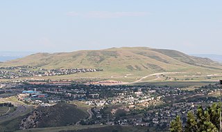
Green Mountain is a mesa on the eastern flank of the Front Range of the Rocky Mountains of North America. The 6,854-foot (2,089 m) mesa summit is located in William Frederick Hayden Park in the City of Lakewood, Colorado, United States, 4.0 miles (6.5 km) west of the municipal center of Lakewood in Jefferson County.

Mount Morrison is a foothill on the eastern flank of the Front Range of the Rocky Mountains of North America. The 7,881-foot (2,402 m) peak is located in Red Rocks Park, 1.9 miles (3.0 km) northwest by west of the Town of Morrison in Jefferson County, Colorado, United States. Red Rocks Amphitheatre is located on the eastern side of the mountain.