This article needs additional citations for verification .(August 2020) |
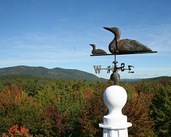
Pleasant Mountain is located in Bridgton and Denmark, Maine, in the United States.
Over 2,000 acres on the east side of Pleasant Mountain is owned and managed by Loon Echo Land Trust. The Trust also maintains the 10-mile trail network on the mountain. [1] Pleasant Mountain Ski Area is located on the north side of the mountain. The northern slope of the Pleasant Mountain is also the highest point in Cumberland County, Maine.
Livermore is a town in Androscoggin County, Maine, United States. Formerly in Oxford County, Maine. The population was 2,127 at the 2020 United States Census. It is included in both the Lewiston-Auburn, Maine Metropolitan Statistical Area and the Lewiston-Auburn, Maine Metropolitan New England City and Town Area. High schools students from Livermore attend Spruce Mountain High School in neighboring Livermore Falls. Livermore is known for The Norlands, the Washburn family home.
Bethel is a town in Oxford County, Maine, United States. The population was 2,504 at the 2020 census. It includes the villages of Bethel and West Bethel. The town is home to Gould Academy, a private preparatory school, and is near the Sunday River ski resort.
South Paris is a census-designated place (CDP) located within the town of Paris in Oxford County, Maine, in the United States. The population was 2,237 at the 2000 census. While the CDP refers only to the densely settled area in the southern part of the town of Paris, the entire town, outside of Paris Hill, is located within the South Paris ZIP code, resulting in many residents referring to the entire town as South Paris.
Hometown is a village in Rush Township, Schuylkill County, Pennsylvania, United States that sits astride a crossing point between important transportation corridors. The population was 1,399 at the 2000 census, and excepting for the area near the east–west PA 54 running mostly parallel to the tracks of the Reading, Blue Mountain, and Northern Railroad — once the important E-W shortline Nesquehoning & Mahanoy Railroad — and the PA 54 junction with PA 309.
Conway is a town in Carroll County, New Hampshire, United States. It is the most populous community in the county, with a population of 9,822 at the 2020 census, down from 10,115 at the 2010 census. The town is on the southeastern edge of the White Mountain National Forest. There are five villages in the town: Conway, North Conway, Center Conway, Redstone and Kearsarge. Additionally, it shares a portion of the village of Intervale with the neighboring town of Bartlett.
The Androscoggin River is a river in the U.S. states of Maine and New Hampshire, in northern New England. It is 178 miles (286 km) long and joins the Kennebec River at Merrymeeting Bay in Maine before its water empties into the Gulf of Maine on the Atlantic Ocean. Its drainage basin is 3,530 square miles (9,100 km2) in area. The name "Androscoggin" comes from the Eastern Abenaki term /aləssíkɑntəkw/ or /alsíkɑntəkw/, meaning "river of cliff rock shelters" ; or perhaps from Penobscot /aləsstkɑtəkʷ/, meaning "river of rock shelters". The Anglicization of the Abenaki term is likely an analogical contamination with the colonial governor Edmund Andros.
Moose Island is an island in Eastport, Maine located at the entrance to Cobscook Bay from Passamaquoddy Bay in the Bay of Fundy. It is part of Shackford Head State Park.
Pleasant River is a 4.7-mile-long (7.6 km) river in Oxford County, Maine in the United States. It is a tributary of the Androscoggin River, which flows east and south to join the Kennebec River in Merrymeeting Bay near the Atlantic Ocean.
The High Peaks is a region of the US state of Maine, lying entirely within Franklin County. It is roughly bounded by State Route 4 to the southwest, State Route 16 to the northwest, State Route 16/27 to the northeast and State Route 142 to the southeast. The region contains eight of the 14 Maine 4,000-footers and includes 21,000 acres (85 km2) above 2,700 feet (820 m). By comparison, Baxter State Park, which contains Maine's highest mountain, Mount Katahdin, and has a similar overall land area, has 39% less land over 2700 feet. The Appalachian Trail passes through the area, covering a distance of 32.2 miles (52 km) and climbing a total of 10,000 feet (3,000 m).
The Ski Museum of Maine in Kingfield, Maine, United States, is devoted to preserving and presenting the history and heritage of skiing. The museum has an emphasis on artifacts and documents relating to the state of Maine. In 2009, the museum relocated from Farmington to Kingfield. It is now located on Route 27 in downtown Kingfield, near the historic Herbert Hotel and 15 miles (24 km) from Sugarloaf Mountain.
North Moat Mountain is a mountain located in Carroll County, New Hampshire. North Moat is flanked to the south by Middle Moat Mountain, and to the west by Big Attitash Mountain.
Greenwood Mountain is the name of several mountain summits in the United States.
There are a number of wind power projects in the state of Maine, totaling more than 900 megawatts (MW) in capacity. In 2020 they were responsible for 24% of in-state electricity production. In 2019, Maine had more wind capacity than the other five New England states combined, at 923 MW.
Pleasant Mountain is a ski resort located in Bridgton, Maine, in Cumberland County.
The East Branch Pleasant River is a 6.2-mile-long (10.0 km) tributary of the Pleasant River in the U.S. state of Maine. The Pleasant River is a tributary of the Androscoggin River, which flows southeast to the tidal Kennebec River and the Atlantic Ocean.
The Sanborn River is a 5.8-mile-long (9.3 km) river in Maine. It flows from its source on Round Mountain in the unorganized territory of South Oxford to Hicks Pond in the town of Greenwood. Hicks Pond drains via Niles Brook into the Little Androscoggin River, the Androscoggin River, and thence into Merrymeeting Bay in the Kennebec River estuary.
The West Branch Pleasant River is a 7.5-mile-long (12.1 km) tributary of the Pleasant River in the U.S. state of Maine. It is part of the Androscoggin River watershed, which flows to the tidal Kennebec River near its mouth at the Atlantic Ocean.
The West Branch Pleasant River is a 36.1-mile-long (58.1 km) tributary of the Piscataquis River in Piscataquis County, Maine. From a location north of Fourth West Branch Pond in Shawtown, the river runs about 18 miles (29 km) counterclockwise around the White Cap Mountain massif, then about 18 miles (29 km) southeast to its confluence with the East Branch of the Pleasant River in Brownville.
Casco is a census-designated place (CDP) in the town of Casco in Cumberland County, Maine, United States. The population of the CDP was 587 at the 2010 census. It is part of the Portland–South Portland–Biddeford, Maine Metropolitan Statistical Area.
Teddington Park is a neighbourhood in Toronto, Ontario, Canada. It is bordered by Yonge Street to the west and Bayview Avenue to the east, and from Snowden Road in the south to north of Glen Echo Road and Rosedale Golf Club. Development occurred in and around the 1930s, and was farmland before that time.