Greenwood Mountain is the name of several mountain summits in the United States.
There are two peaks in the U.S. state of Maine, one in Piscataquis County, which climbs to 1,129 feet (344 m) above the sea level at 45°21′36″N69°23′27″W / 45.360049°N 69.390883°W / 45.360049; -69.390883 5.9 miles (9.5 km) away from the town of Monson, [1] and the other being in Oxford County, which climbs to 761 feet (232 m) and is located at 44°12′00″N70°22′46″W / 44.200071°N 70.379502°W / 44.200071; -70.379502 0.9 miles (1.4 km) away from the village of Hebron and circa 14 miles (23 km) far from the city of Lewiston. [2]
The state of West Virginia has also two peaks. The first is located in Fayette County, 0.8 miles (1.3 km) away of the unincorporated area of Maplewood, at 2,871 feet (875 m) of altitude and is geolocated at 37°53′22″N80°59′02″W / 37.88956°N 80.983984°W / 37.88956; -80.983984 . [3] while the second summit is in Tucker County, climbs to 3,507 feet (1,069 m), and is located at 39°00′47″N79°37′00″W / 39.013163°N 79.616725°W / 39.013163; -79.616725 , 2.9 miles (4.7 km) from Red Creek. [4]
Greenwood Mountain is also a mountain summit in Burnet County in the state of Texas. It climbs to 1,401 feet (427 m) and is located at 31°00′29″N98°25′40″W / 31.00795°N 98.427812°W / 31.00795; -98.427812 , 6.7 miles (10.8 km) away from Bend. [5]
There is also another peak in Lake County, Minnesota. It is one of the lesser peaks of the Sawtooth Mountains of northeastern Minnesota, with a height of only 145 feet (44 m) above its small lake, which is at its north side. [6]

Piscataquis County is a county located in the U.S. state of Maine. As of the 2010 census, its population was 17,535, making it Maine's least-populous county. Its county seat is Dover-Foxcroft. The county was incorporated on 23 March 1838, taken from the western part of Penobscot County and the eastern part of Somerset County, and is named for an Abenaki word meaning "branch of the river" or "at the river branch."

Greenwood is a town in Oxford County, Maine, United States. The population was 830 at the 2010 census. The town was named for surveyor Alexander Greenwood. The village of Locke Mills, on State Route 26 in the northern part of Greenwood, is the town's urban center and largest settlement.

Mount Katahdin is the highest mountain in the U.S. state of Maine at 5,269 feet (1,606 m). Named Katahdin by the Penobscot Native Americans, which means "The Greatest Mountain", it is located within Northeast Piscataquis, Piscataquis County, and is the centerpiece of Baxter State Park. It is a steep, tall massif formed from a granite intrusion weathered to the surface. The flora and fauna on the mountain are typical of those found in northern New England.
The Presidential Range is a mountain range in the Green Mountains of the U.S. state of Vermont. All of the summits of the peaks in the range are located in Addison County but the eastern slopes in the northern part of the range extend into Washington County. The major peaks in the range are named for several U.S. presidents from the period of the American Civil War through World War I.

Torreys Peak is a mountain in the Front Range region of the Rocky Mountains in Colorado. It is one of 53 fourteeners in Colorado. Its nearest major city is Denver. Torreys Peak is located along the Continental Divide, as well as the division between Clear Creek County and Summit County.
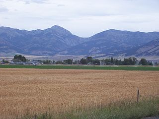
The Bridger Range, also known as the Bridger Mountains, is a subrange of the Rocky Mountains in southwestern Montana in the United States. The range runs mostly in a north–south direction between Bozeman and Maudlow. It is separated from the Gallatin Range to the south by Bozeman Pass; from the Horseshoe Hills to the west by Dry Creek; from the Crazy Mountains to the east by the Shields River valley; and from the Big Belt Mountains to the north by Sixteen Mile Creek. The highest point in the Bridger Range is Sacagawea Peak, which is visible to the northeast from Bozeman.

Kings Peak is the highest peak in the U.S. state of Utah, with an elevation of 13,534 feet (4,125 m) NAVD 88.
The Piscataquis River is a major tributary of the Penobscot River, found in Piscataquis County, Maine, United States. It starts from the confluence of its East Branch and West Branch in Blanchard. The river flows in a mostly eastern direction until it meets the Penobscot at Howland. It is approximately 65 miles (105 km) in length.
Rich Mountain, elevation 4,040 feet (1,230 m), is the highest point in the Rich Mountain Wilderness of the Chattahoochee National Forest in Gilmer County, Georgia. It is the second-highest peak in Gilmer County; only Big Bald Mountain is taller, with its summit at 4,081 feet (1,244 m).
The Appalachian National Scenic Trail spans fourteen U.S. states during its roughly 2,200 miles (3,500 km)-long journey: Georgia, North Carolina, Tennessee, Virginia, West Virginia, Maryland, Pennsylvania, New Jersey, New York, Connecticut, Massachusetts, Vermont, New Hampshire, and Maine. The southern end is at Springer Mountain, Georgia, and it follows the ridgeline of the Appalachian Mountains, crossing many of its highest peaks and running almost continuously through wilderness before reaching the northern end at Mount Katahdin, Maine.

White Cap Mountain is a mountain located in Piscataquis County, Maine. White Cap Mountain is flanked to the east by Hay Mountain, to the south by Big Spruce Mountain and to the southeast by Little Spruce Mountain.
Doubletop Mountain is a mountain located in Piscataquis County, Maine, in Baxter State Park. According to Fannie Hardy Eckstorm, the mountain's Indigenous name was Psinskihegan-I-Outop. Psinskihegan means notch and I-Outop means head. in 1828 in the Survey of Maine, Moses Greenleaf called the mountain a variation Chinskihegan or Outop. It eventually became Doubletop, named for its two peaks.
The High Peaks is a region of the US state of Maine, lying entirely within Franklin County. It is roughly bounded by State Route 4 to the southwest, State Route 16 to the northwest, State Route 16/27 to the northeast and State Route 142 to the southeast. The region contains eight of the 14 Maine 4,000-footers and includes 21,000 acres (85 km2) above 2,700 feet (820 m). By comparison, Baxter State Park, which contains Maine's highest mountain, Mount Katahdin, and has a similar overall land area, has 39% less land over 2700 feet. The Appalachian Trail passes through the area, covering a distance of 32.2 miles (52 km) and climbing a total of 10,000 feet (3,000 m).
Rocky Mountain is a peak of the Blue Ridge Mountains in Virginia. It is located about 2 miles (3.5 km) east of Irish Gap, on the border of Rockbridge County and Amherst County; it is the highest point of both counties. Rocky Mountain is flanked to the northeast by Elk Pond Mountain, to the southwest by Grapevine Ridge, and to the south by Tar Jacket Ridge.
The East Branch Pleasant River is a 32.4-mile-long (52.1 km) tributary of the Piscataquis River in Piscataquis County, Maine. From its source in Shawtown, the river runs about 19 miles (31 km) generally southeast to Upper Ebeemee Lake, then about 13 miles (21 km) south through Ebeemee Lake to its confluence with the West Branch to form the Pleasant River in Brownville.
The Sebec River is a tributary of the Piscataquis River in Piscataquis County, Maine. From the outflow of Sebec Lake in Sebec, the river runs 10.0 miles (16.1 km) east and southeast to its confluence with the Piscataquis in Milo.
The West Branch Piscataquis River is a 22-mile-long (35 km) tributary of the Piscataquis River in Piscataquis County, Maine. Its source is in East Moxie, Somerset County . The river runs about 6 miles (10 km) east, then 11 miles (18 km) south, then 5 miles (8 km) east to its confluence with the East Branch Piscataquis River in Blanchard to form the Piscataquis.
The West Branch Pleasant River is a 36.1-mile-long (58.1 km) tributary of the Piscataquis River in Piscataquis County, Maine. From a location north of Fourth West Branch Pond in Shawtown, the river runs about 18 miles (29 km) counterclockwise around the White Cap Mountain massif, then about 18 miles (29 km) southeast to its confluence with the East Branch of the Pleasant River in Brownville.
Elephant Mountain is a mountain located in Bowdoin College Grant West Piscataquis County, Maine. It is about 5 miles (8 km) southeast of Moosehead Lake, 2 miles southwest of Baker Mountain, and 5 miles west of White Cap Mountain.
There are 21 mountain peaks named West Peak in the United States according to the US Geological Survey Geographic Names Information System.