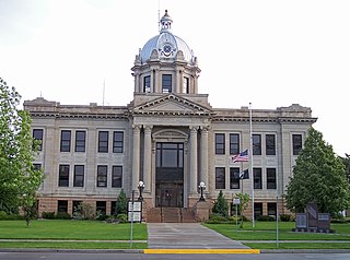
Richland County is a county in the far southeast corner of the U.S. state of North Dakota. As of the 2020 census, the population was 16,529. Its county seat is Wahpeton.

Winona County is a county in the U.S. state of Minnesota. As of the 2020 census, its population was 49,671. Its county seat is Winona. Winona County comprises the Winona, MN Micropolitan Statistical Area.

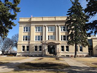
Wadena County is a county in the U.S. state of Minnesota. As of the 2020 census, the population was 14,065. Its county seat is Wadena.

Todd County is a county in the central part of the U.S. state of Minnesota. As of the 2020 census, the population was 25,262. Its county seat is Long Prairie.
Otter Tail County is a county in the U.S. state of Minnesota. As of the 2020 census, its population was 60,081. Its county seat is Fergus Falls. Otter Tail County comprises the Fergus Falls micropolitan statistical area. With 1,048 lakes in its borders, Otter Tail County has more lakes than any other county in the United States.

Douglas County is a county in the U.S. state of Minnesota. As of the 2020 census, the population was 39,006. Its county seat is Alexandria.

Cass County is a county in the central part of the U.S. state of Minnesota. As of the 2020 census, the population was 30,066. Its county seat is Walker. The county was formed in 1851, and was organized in 1897.
Stowe Prairie Township is a township in Todd County, Minnesota, United States. The population was 529 at the 2000 census. It had declined to 488 people by the 2020 census.
Mille Lacs Indian Reservation is the popular name for the land-base for the Mille Lacs Band of Ojibwe in Central Minnesota, about 100 miles (160 km) north of Minneapolis-St. Paul. The contemporary Mille Lacs Band reservation has significant land holdings in Mille Lacs, Pine, Aitkin and Crow Wing counties, as well as other land holdings in Kanabec, Morrison, and Otter Tail Counties. Mille Lacs Indian Reservation is also the name of a formal Indian reservation established in 1855. It is one of the two formal reservations on which the contemporary Mille Lacs Band retains land holdings. The contemporary Mille Lacs band includes several aboriginal Ojibwe bands and villages, whose members reside in communities throughout central Minnesota.

The Battle of Dead Buffalo Lake was a skirmish in July 1863 in Dakota Territory between United States army forces and Santee, Yankton, Yanktonai and Teton Sioux. The Sioux attempted to capture the pack train of the army and retired from the field when they were unsuccessful.
Mount Nebo is a mountain in the present-day Western Jordan on which, according to the Bible, the prophet Moses died.

Wadena is an unincorporated community in Union Township, Benton County, in the U.S. state of Indiana. It is part of the Lafayette, Indiana Metropolitan Statistical Area.
The Dromedary Hills are an area of morainic drift hills in section 28, Little Elk Township in Todd County, Minnesota, United States. These hills were named for their rounded outlines, like a camel's hump. The Dromedary Hills are one of only two hills or "localities of hills" in Todd County which have received names on maps, the other being Mount Nebo.
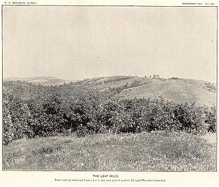
The Leaf Hills Moraines, sometimes called the Leaf Mountains, are a range of hills in west-central Minnesota. The land does not exhibit many characteristics of mountains, but nevertheless rises typically to a height of 100 to 300 feet above the surrounding farmland, occasionally reaching higher than 350 feet (107 m). The name of this range of hills is translated from the Ojibwe Gaaskibag-wajiwan, which was interpreted by Gilfillan as “Rustling Leaf Mountains.” The name is also shared by Leaf Mountain Township, the two Leaf Lakes ("Gaaskibag-wajiwi-zaaga'iganan"), and the Leaf River ("Gaaskibag-wajiwi-ziibi"), all named for the hills. In turn, the hills in Ojibwe are named after Inspiration Peak ("Gaaskibag-wajiw"), a prominent hill in this area.

Inspiration Peak is a glacial feature of the Leaf Hills Moraines and of Otter Tail County in the U.S. State of Minnesota and is the second highest peak in Otter Tail County. It is 22 miles (35 km) northwest of Alexandria. The peak rises about 310 feet (94 m) above the surrounding plains, to an elevation of about 1,727 feet (526 m) above sea level. It is the central feature of Inspiration Peak State Wayside, a small recreation area maintained by the Minnesota Department of Natural Resources, which manages it from nearby Lake Carlos State Park. The wayside has a paved parking lot and a picnic area. The hike to the top is a short but strenuous walk up a well-worn trail from the parking lot. Higher terrain is located about five miles northeast of Inspiration Peak. Pekan Peak in Section 32, Folden Township, Otter Tail County, discovered by John Sandy in February 2022, at coordinates 46°11′54.744″ N 95°30′4.248″ W (DMS), Latitude 46.19854 Longitude -95.50118 (DD), has an elevation of 1,800.05 feet, measured by LiDAR technology.

Nebo Hill Archeological Site is a prominent former river bluff located in Liberty, Missouri. It has one of the highest elevations in Clay County. One source states the hill is named after the family who owned the property in the 1900s, while according to another source the name is a transfer from Mount Nebo in Jordan.
Wadena Air Force Station is a closed United States Air Force General Surveillance Radar station. It is located 7 miles (11 km) north-northeast of Wadena, Minnesota. It was closed in 1970.
Nebo is an unincorporated community in eastern Laclede County, in the Ozarks of southern Missouri. The community lies on Missouri Route 32, approximately five miles northwest of Lynchburg and about fifteen miles southeast of Lebanon. The site is within the Mark Twain National Forest.
Oakside is an unincorporated community in western Shannon County, in the U.S. state of Missouri.