Hewitt, Minnesota

Last updated

Hewitt
Hewitt Public School Museum-SW view.jpg
Hewitt Public School Museum
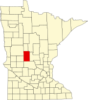
Todd County Minnesota Incorporated and Unincorporated areas Hewitt Highlighted.svg
Location of Hewitt, Minnesota
Coordinates: 46°19′26″N95°05′25″W / 46.32389°N 95.09028°W / 46.32389; -95.09028
Country United States
State Minnesota
County Todd
Area
[1]
  Total2.06 sq mi (5.34 km2)
  Land2.06 sq mi (5.34 km2)
  Water0.00 sq mi (0.00 km2)
Elevation
[2]
1,371 ft (418 m)
Population
 (2020)
  Total251
  Density121.67/sq mi (46.97/km2)
Time zone UTC-6 (Central (CST))
  Summer (DST) UTC-5 (CDT)
ZIP code
56453
Area code 218
FIPS code 27-28754 [3]
GNIS feature ID2394367 [2]

Hewitt is a city in Todd County, Minnesota, United States, along the Wing River. The population was 266 at the 2010 census. [4] It was 251 by the time of the 2020 Decennial Census. [5]

Contents

History

Hewitt was platted in 1891, and named for Henry Hewitt, an early settler. [6] A post office has been in operation at Hewitt since 1891. [7] The Hewitt Public School, built in 1911, is listed on the National Register of Historic Places. [8]

Geography

According to the United States Census Bureau, the city has a total area of 2.05 square miles (5.31 km2), all land. [9]

U.S. Route 71 and Minnesota State Highway 210 are two of the main routes in the community.

Demographics

Historical population
CensusPop.Note
1900 311
1910 3223.5%
1920 39923.9%
1930 309−22.6%
1940 294−4.9%
1950 3126.1%
1960 267−14.4%
1970 198−25.8%
1980 29951.0%
1990 269−10.0%
2000 267−0.7%
2010 266−0.4%
2020 251−5.6%
U.S. Decennial Census [10]

2010 census

As of the census [11] of 2010, there were 266 people, 113 households, and 64 families living in the city. The population density was 129.8 inhabitants per square mile (50.1/km2). There were 129 housing units at an average density of 62.9 per square mile (24.3/km2). The racial makeup of the city was 100.0% White. Hispanic or Latino of any race were 1.1% of the population.

There were 113 households, of which 28.3% had children under the age of 18 living with them, 46.0% were married couples living together, 6.2% had a female householder with no husband present, 4.4% had a male householder with no wife present, and 43.4% were non-families. 36.3% of all households were made up of individuals, and 15.9% had someone living alone who was 65 years of age or older. The average household size was 2.35 and the average family size was 3.17.

The median age in the city was 40.3 years. 25.2% of residents were under the age of 18; 5.6% were between the ages of 18 and 24; 25.2% were from 25 to 44; 28.2% were from 45 to 64; and 15.8% were 65 years of age or older. The gender makeup of the city was 46.6% male and 53.4% female.

2000 census

As of the census [3] of 2000, there were 267 people, 109 households, and 69 families living in the city. The population density was 130.3 inhabitants per square mile (50.3/km2). There were 122 housing units at an average density of 59.5 per square mile (23.0/km2). The racial makeup of the city was 98.88% White, 0.37% Native American, 0.37% Asian, and 0.37% from two or more races. Hispanic or Latino of any race were 0.75% of the population.

There were 109 households, out of which 29.4% had children under the age of 18 living with them, 51.4% were married couples living together, 6.4% had a female householder with no husband present, and 35.8% were non-families. 27.5% of all households were made up of individuals, and 14.7% had someone living alone who was 65 years of age or older. The average household size was 2.41 and the average family size was 2.90.

In the city, the population was spread out, with 23.6% under the age of 18, 10.5% from 18 to 24, 24.0% from 25 to 44, 22.8% from 45 to 64, and 19.1% who were 65 years of age or older. The median age was 38 years. For every 100 females, there were 110.2 males. For every 100 females age 18 and over, there were 104.0 males.

The median income for a household in the city was $26,161, and the median income for a family was $27,500. Males had a median income of $22,500 versus $18,750 for females. The per capita income for the city was $12,520. About 7.7% of families and 13.4% of the population were below the poverty line, including 7.3% of those under the age of eighteen and 18.1% of those 65 or over.

Related Research Articles

<span class="mw-page-title-main">Cromwell, Minnesota</span> City in Minnesota, United States

Cromwell is a city in Carlton County, Minnesota, United States. The population was 240 at the 2020 census.

<span class="mw-page-title-main">Maynard, Minnesota</span> City in Minnesota, United States

Maynard is a city in Chippewa County, Minnesota, United States. The population was 366 at the 2010 census.

<span class="mw-page-title-main">Easton, Minnesota</span> City in Minnesota, United States

Easton is a city in Faribault County, Minnesota, United States. The population was 199 at the 2010 census.

<span class="mw-page-title-main">Frost, Minnesota</span> City in Minnesota, United States

Frost is a city in Faribault County, Minnesota, United States. The population was 215 at the 2020 census.

<span class="mw-page-title-main">Alden, Minnesota</span> City in Minnesota, United States

Alden is a city in Freeborn County, Minnesota, United States. The population was 661 at the 2010 census.

<span class="mw-page-title-main">Calumet, Minnesota</span> City in Minnesota, United States

Calumet is a city in Itasca County, Minnesota, United States. The population was 334 at the 2020 census.

<span class="mw-page-title-main">La Prairie, Minnesota</span> City in Minnesota, United States

La Prairie is a city in Itasca County, Minnesota, United States. The population was 653 at the 2020 census.

<span class="mw-page-title-main">Blomkest, Minnesota</span> City in Minnesota, United States

Blomkest is a city in Kandiyohi County, Minnesota, United States. The population was 157 at the 2010 census.

<span class="mw-page-title-main">Bellingham, Minnesota</span> City in Minnesota, United States

Bellingham is a city in Lac qui Parle County, Minnesota, United States. The population was 168 at the 2010 census.

<span class="mw-page-title-main">Russell, Minnesota</span> City in Minnesota, United States

Russell is a city in Lyon County, Minnesota, United States. The population was 348 at the 2020 census.

<span class="mw-page-title-main">Hillman, Minnesota</span> City in Minnesota, United States

Hillman is a city in Morrison County, Minnesota, United States. The population was 23 at the 2020 census.

<span class="mw-page-title-main">Brook Park, Minnesota</span> City in Minnesota, United States

Brook Park is a city in Pine County, Minnesota, United States. The population was 139 at the 2010 census.

<span class="mw-page-title-main">Cyrus, Minnesota</span> City in Minnesota, US

Cyrus is a city in Pope County, Minnesota, United States, along the Chippewa River. The population was 305 at the 2020 census.

<span class="mw-page-title-main">Cook, Minnesota</span> City in Minnesota, United States

Cook is a city in Saint Louis County, Minnesota, United States. The population was 534 at the 2020 census.

<span class="mw-page-title-main">Elrosa, Minnesota</span> City in Minnesota, United States

Elrosa is a city in Stearns County, Minnesota, United States. The population was 211 at the 2010 census. It is part of the St. Cloud Metropolitan Statistical Area.

<span class="mw-page-title-main">Ellendale, Minnesota</span> City in Minnesota, United States

Ellendale is a city in Steele County, Minnesota, United States. The population was 691 at the 2010 census.

<span class="mw-page-title-main">Minnesota City, Minnesota</span> City in Minnesota, United States

Minnesota City is a city in Winona County, Minnesota, United States. The population was 202 at the 2020 census.

<span class="mw-page-title-main">Rollingstone, Minnesota</span> City in Minnesota, United States

Rollingstone is a city in Winona County, Minnesota, United States. The population was 678 at the 2020 census.

<span class="mw-page-title-main">Brownsville, Minnesota</span> City in Minnesota, United States

Brownsville is a city in Houston County, Minnesota, United States. The population was 566 at the 2020 census.

<span class="mw-page-title-main">North Mankato, Minnesota</span> City in Minnesota, United States

North Mankato is a city in Nicollet and Blue Earth counties in the State of Minnesota. The population was 14,275 at the 2020 census.

References

  1. "2020 U.S. Gazetteer Files". United States Census Bureau. Retrieved July 24, 2022.
  2. 1 2 U.S. Geological Survey Geographic Names Information System: Hewitt, Minnesota
  3. 1 2 "U.S. Census website". United States Census Bureau . Retrieved January 31, 2008.
  4. "2010 Census Redistricting Data (Public Law 94-171) Summary File". American FactFinder. U.S. Census Bureau, 2010 Census. Retrieved April 23, 2011.[ dead link ]
  5. Bureau, US Census. "Minnesota's Population at 5,706,494 in 2020, Up 7.6% Since 2010". Census.gov. Retrieved August 6, 2023.
  6. Upham, Warren (1920). Minnesota Geographic Names: Their Origin and Historic Significance. Minnesota Historical Society. p.  544.
  7. "Todd County". Jim Forte Postal History. Retrieved August 10, 2015.
  8. "National Register Information System". National Register of Historic Places . National Park Service. July 9, 2010.
  9. "US Gazetteer files 2010". United States Census Bureau. Archived from the original on January 25, 2012. Retrieved November 13, 2012.
  10. "Census of Population and Housing". Census.gov. Retrieved June 4, 2015.
  11. "U.S. Census website". United States Census Bureau . Retrieved November 13, 2012.