Villard Township, Todd County, Minnesota

Last updated

Villard Township, Minnesota
USA Minnesota location map.svg
Red pog.svg
Villard Township, Minnesota
Location within the state of Minnesota
Usa edcp location map.svg
Red pog.svg
Villard Township, Minnesota
Villard Township, Minnesota (the United States)
Coordinates: 46°19′7″N94°43′29″W / 46.31861°N 94.72472°W / 46.31861; -94.72472
Country United States
State Minnesota
County Todd
Area
  Total31.7 sq mi (82.1 km2)
  Land30.1 sq mi (78.0 km2)
  Water1.6 sq mi (4.1 km2)
Elevation
1,247 ft (380 m)
Population
 (2020)
  Total667
  Density19.7/sq mi (7.6/km2)
Time zone UTC-6 (Central (CST))
  Summer (DST) UTC-5 (CDT)
FIPS code 27-67162 [1]
GNIS feature ID0665875 [2]

Villard Township is a township in Todd County, Minnesota, United States. The population was 592 at the 2000 census and was 667 at the time of the 2020 census. [3]

Contents

Villard Township was organized in 1882, and named for Henry Villard, a railroad official. [4]

Geography

According to the United States Census Bureau, the township has a total area of 31.7 square miles (82.1 km2); 30.1 square miles (78.0 km2) is land and 1.6 square miles (4.1 km2) (4.99%) is water. Villard township has several lakes including Hayden [5] and Lawrence Lake [6] which has the 161 acre Lawrence Lake Wildlife Management Area [7] which is primarily located on its South side. The Wildlife Management Area is a mixture of oak, aspen, and pine forests. Management of this unit by the Minnesota DNR focuses on maintaining and improving the habitat for a diversity of native plants and wildlife.

The Crow Wing River defines the Northeastern boundary of the township. Cass County is to the North of the River.

Villages

Philbrook is an unincorporated village on the southern edge of the township. In the past it had both a post office and a Northern Pacific Railroad station located in the village. Philbrook was also known as Riverside since its on the banks of the Long Prairie River. Hayden, in Section 9 of the township,also had a Northern Pacific station. [4]

Demographics

As of the census [1] of 2000, there were 592 people, 210 households, and 161 families residing in the township. The population density was 19.7 people per square mile (7.6/km2). There were 243 housing units at an average density of 8.1/sq mi (3.1/km2). The racial makeup of the township was 97.97% White, 0.17% African American, 0.17% Native American, 0.68% Asian, and 1.01% from two or more races. Hispanic or Latino of any race were 0.17% of the population.

There were 210 households, out of which 36.2% had children under the age of 18 living with them, 68.6% were married couples living together, 5.2% had a female householder with no husband present, and 23.3% were non-families. 18.1% of all households were made up of individuals, and 7.1% had someone living alone who was 65 years of age or older. The average household size was 2.80 and the average family size was 3.23.

In the township the population was spread out, with 28.9% under the age of 18, 7.4% from 18 to 24, 23.5% from 25 to 44, 30.7% from 45 to 64, and 9.5% who were 65 years of age or older. The median age was 38 years. For every 100 females, there were 103.4 males. For every 100 females age 18 and over, there were 104.4 males.

The median income for a household in the township was $40,556, and the median income for a family was $47,500. Males had a median income of $28,523 versus $22,031 for females. The per capita income for the township was $16,025. About 4.5% of families and 7.9% of the population were below the poverty line, including 3.1% of those under age 18 and 11.9% of those age 65 or over.

Related Research Articles

<span class="mw-page-title-main">Todd County, Minnesota</span> County in Minnesota, United States

Todd County is a county in the central part of the U.S. state of Minnesota. As of the 2020 census, the population was 25,262. Its county seat is Long Prairie.

<span class="mw-page-title-main">Pope County, Minnesota</span> County in Minnesota, United States

Pope County is a county in the U.S. state of Minnesota. As of the 2020 census, the population was 11,308. Its county seat is Glenwood. The county was formed in 1862 and organized in 1866.

<span class="mw-page-title-main">Mahnomen County, Minnesota</span> County in Minnesota, United States

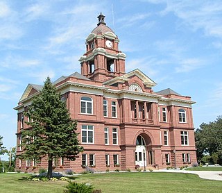
Mahnomen County is a county in the U.S. state of Minnesota. As of the 2020 census, the population was 5,411. Its county seat is Mahnomen.

<span class="mw-page-title-main">Lyon County, Minnesota</span> County in Minnesota, United States

Lyon County is a county in the U.S. state of Minnesota. As of the 2020 census, the population was 25,269. Its county seat is Marshall.

<span class="mw-page-title-main">Kandiyohi County, Minnesota</span> County in Minnesota, United States

Kandiyohi County is a county in the U.S. state of Minnesota. As of the 2020 census, its population is 43,732. As of November 20, 1871, its county seat is Willmar.

<span class="mw-page-title-main">Grant County, Minnesota</span> County in Minnesota, United States

Grant County is a county in the U.S. state of Minnesota. As of the 2020 census, the population was 6,074. Its county seat is Elbow Lake.

<span class="mw-page-title-main">Columbus, Minnesota</span> City in Minnesota, United States

Columbus is a city in Anoka County, Minnesota, United States. The population was 3,914 at the 2010 census.

Becker Township is a township in Cass County, Minnesota, United States. The population was 485 as of the 2000 census. Becker Township was named for J. A. Becker, a pioneer settler.

May Township is a township in Cass County, Minnesota, United States. The population was 730 at the 2000 census. May Township was named for May Griffith, the daughter of a county official.

<span class="mw-page-title-main">Crosslake, Minnesota</span> City in Minnesota, United States

Crosslake is a city in Crow Wing County, Minnesota, United States. The population was 2,141 at the 2010 census. It is part of the Brainerd Micropolitan Statistical Area.

Perry Lake Township is a township located in Crow Wing County, Minnesota, United States. The population was 237 at the 2000 census. This township took its name from Perry Lake.

<span class="mw-page-title-main">Carlos, Minnesota</span> City in Minnesota, United States

Carlos is a city in Douglas County, Minnesota, United States. The population was 497 at the 2020 census.

<span class="mw-page-title-main">The Lakes, Minnesota</span> Unincorporated community in Minnesota, US

The Lakes is an unincorporated community and census-designated place (CDP) in Murray County, Minnesota, United States located just north of Currie, Minnesota. The population was 667 at the 2010 census. The community is centered about Lake Shetek, the largest lake in southwestern Minnesota. The lake and the community are located in parts of four townships in Murray County, which include Lake Sarah, Shetek, Murray, and Mason Townships.

Canosia Township is an urban township in Saint Louis County, Minnesota, United States. Canosia is a name derived from the Algonquian language meaning "pike fish". The population was 2,158 at the 2010 census.

Pequaywan Township is a township in Saint Louis County, Minnesota, United States. The population was 130 at the 2010 census.

Turtle Creek Township is a township in Todd County, Minnesota, United States. The population was 323 at the 2000 census and was 270 at the time of the 2020 census.

Ward Township is a township in Todd County, Minnesota, United States. The population was 471 at the 2000 census and 474 at the 2020 census.

West Union Township is a township in Todd County, Minnesota, United States. The population was 312 at the 2000 census and 254 in the 2020 census. The incorporated village of West Union is within the township of the same name.

Bruce Township is a township in Todd County, Minnesota, United States. The population was 564 at the 2000 census but had declined to 479 by the 2020 census.

Southside Township is in Wright County, Minnesota, United States. The population was 1,576 at the 2000 census.

References

  1. 1 2 "U.S. Census website". United States Census Bureau . Retrieved January 31, 2008.
  2. "US Board on Geographic Names". United States Geological Survey. October 25, 2007. Retrieved January 31, 2008.
  3. Bureau, US Census. "Minnesota's Population at 5,706,494 in 2020, Up 7.6% Since 2010". Census.gov. Retrieved April 17, 2023.
  4. 1 2 Upham, Warren (1920). Minnesota Geographic Names: Their Origin and Historic Significance. Minnesota Historical Society. p.  546.
  5. "Hayden (77008000) | LakeFinder". Minnesota Department of Natural Resources. Retrieved February 1, 2024.
  6. "Lawrence (77008300) | LakeFinder". Minnesota Department of Natural Resources. Retrieved February 1, 2024.
  7. "Lawrence Lake WMA: Main Unit". Minnesota Department of Natural Resources. Retrieved February 1, 2024.