Grey Eagle | |
---|---|
Coordinates: 45°49′27″N94°44′56″W / 45.82417°N 94.74889°W | |
Country | United States |
State | Minnesota |
County | Todd |
Area | |
• Total | 0.36 sq mi (0.92 km2) |
• Land | 0.36 sq mi (0.92 km2) |
• Water | 0.00 sq mi (0.00 km2) |
Elevation | 1,227 ft (374 m) |
Population (2020) | |
• Total | 330 |
• Density | 926.97/sq mi (357.61/km2) |
Time zone | UTC-6 (Central (CST)) |
• Summer (DST) | UTC-5 (CDT) |
ZIP code | 56336 |
Area code | 320 |
FIPS code | 27-26000 [3] |
GNIS feature ID | 2394249 [2] |
Website | www |
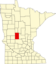
Grey Eagle is a city in Todd County, Minnesota, United States. The population was 348 at the 2010 census. [4] By the 2020 Decennial Census the population had declined to 330. [5]
Grey Eagle was platted in 1882, and named after an early settler, A.M. Crowell, who had shot an eagle near the original town site. The first post office opened in the town of Grey Eagle, which is sections 7 and 8 of the township, in 1877. The town had a Northern Pacific Railroad station. [6] The town is located near the banks of Trace Lake.
Grey Eagle is located less than five miles from Burtrum, a town of 144 notable for its abandoned schoolhouse. [7]
According to the United States Census Bureau, the city has a total area of 0.37 square miles (0.96 km2), all land. [8]
Minnesota State Highways 28 and 287 are two of the main routes in the community.
Census | Pop. | Note | %± |
---|---|---|---|
1900 | 313 | — | |
1910 | 378 | 20.8% | |
1920 | 399 | 5.6% | |
1930 | 363 | −9.0% | |
1940 | 428 | 17.9% | |
1950 | 400 | −6.5% | |
1960 | 372 | −7.0% | |
1970 | 325 | −12.6% | |
1980 | 338 | 4.0% | |
1990 | 353 | 4.4% | |
2000 | 335 | −5.1% | |
2010 | 348 | 3.9% | |
2020 | 330 | −5.2% | |
U.S. Decennial Census [9] |
As of the census [10] of 2010, there were 348 people, 165 households, and 83 families living in the city. The population density was 940.5 inhabitants per square mile (363.1/km2). There were 189 housing units at an average density of 510.8 per square mile (197.2/km2). The racial makeup of the city was 99.4% White and 0.6% Asian. Hispanic or Latino of any race were 0.9% of the population.
There were 165 households, of which 24.2% had children under the age of 18 living with them, 42.4% were married couples living together, 4.2% had a female householder with no husband present, 3.6% had a male householder with no wife present, and 49.7% were non-families. 44.8% of all households were made up of individuals, and 20.6% had someone living alone who was 65 years of age or older. The average household size was 2.11 and the average family size was 3.01.
The median age in the city was 44.6 years. 22.1% of residents were under the age of 18; 7.2% were between the ages of 18 and 24; 21.5% were from 25 to 44; 27.3% were from 45 to 64; and 21.8% were 65 years of age or older. The gender makeup of the city was 51.1% male and 48.9% female.
As of the census [3] of 2000, there were 335 people, 151 households, and 78 families living in the city. The population density was 902.8 inhabitants per square mile (348.6/km2). There were 164 housing units at an average density of 442.0 per square mile (170.7/km2). The racial makeup of the city was 97.01% White, 0.90% African American, 0.30% Asian, and 1.79% from two or more races. Hispanic or Latino of any race were 0.30% of the population.
There were 151 households, out of which 27.8% had children under the age of 18 living with them, 41.1% were married couples living together, 4.6% had a female householder with no husband present, and 48.3% were non-families. 43.0% of all households were made up of individuals, and 20.5% had someone living alone who was 65 years of age or older. The average household size was 2.22 and the average family size was 3.10.
In the city, the population was spread out, with 23.6% under the age of 18, 9.6% from 18 to 24, 29.0% from 25 to 44, 19.4% from 45 to 64, and 18.5% who were 65 years of age or older. The median age was 38 years. For every 100 females, there were 95.9 males. For every 100 females age 18 and over, there were 92.5 males.
The median income for a household in the city was $32,917, and the median income for a family was $38,750. Males had a median income of $28,958 versus $18,750 for females. The per capita income for the city was $15,952. About 12.8% of families and 12.2% of the population were below the poverty line, including 12.9% of those under age 18 and 12.1% of those age 65 or over.
Grey Eagle has three churches, including Saint Joseph Catholic Church, Saint John Evangelical Lutheran Church (LCMS), and Grey Eagle United Methodist Church.
Eagle Lake is in Blue Earth County, Minnesota, United States. The population was 3,278 at the 2020 census. It is part of the Mankato-North Mankato Metropolitan Statistical Area.
Emily is a city in Crow Wing County, Minnesota, United States. The population was 843 at the 2020 census. It is part of the Brainerd Micropolitan Statistical Area.
Ironton is a city in Crow Wing County, Minnesota, United States. The population was 572 at the 2010 census. It is part of the Brainerd Micropolitan Statistical Area.
Trimont is a city in Martin County, Minnesota, United States. The population was 705 at the 2020 census. The small community is located in southern Minnesota between Sherburn and St. James on Minnesota State Highway 4.
Darwin is a city in Meeker County, Minnesota, United States. The population was 348 at the 2020 census.
Lastrup is a city in Morrison County, Minnesota, United States. The population was 120 at the 2020 census.
Clitherall is a city in Otter Tail County, Minnesota, United States. The population was 62 at the 2020 census.
Deer Creek Township is a township in Otter Tail County, Minnesota, United States. The population was 348 at the 2000 census.
Eagle Lake Township is a township in Otter Tail County, Minnesota, United States. The population was 367 at the 2000 census.
Richville is a city in Otter Tail County, Minnesota, United States. The population was 77 as of the 2020 census.
Vergas is a city in northern Otter Tail County, Minnesota, United States. The population was 348 at the 2020 census.
Fairfax is a city in Renville County, Minnesota, United States. The population was 1,250 at the 2020 census.
Lake Henry is a city in Stearns County, Minnesota, United States. The population was 103 at the 2010 census. It is part of the St. Cloud Metropolitan Statistical Area.
Burtrum is a city in Todd County, Minnesota, United States. The population was 144 at the 2010 census. By the 2020 Decennial Census, the population had declined to 123.
Eagle Valley Township is a township in Todd County, Minnesota, United States. The population was 570 at the 2000 census. By the 2020 Census the population had fallen to 487. The township is named for Eagle Creek, which flows through it. Eagle Creek is in turned for the Bald Eagle
Grey Eagle Township is a township in Todd County, Minnesota, United States. The population was 663 according to a 2000 census and was 556 at the time of the 2020 Census.
Dellwood is a city in Washington County, Minnesota, United States and a suburb of St. Paul. The population was 1,063 at the 2010 census.
Barnesville is a city in Clay County, Minnesota, United States. The population was 2,759 at the 2020 census.
Eden Valley is a city in Meeker and Stearns counties in the U.S. state of Minnesota. The population was 1,027 at the 2020 census. Most of Eden Valley is in Meeker County; the Stearns County portion is part of the St. Cloud Metropolitan Statistical Area.
Minneiska is a city in Wabasha and Winona counties in the U.S. state of Minnesota. The population was 97 at the 2020 census.
{{cite web}}
: |last=
has generic name (help)