Ward Township, Todd County, Minnesota

Last updated

Ward Township, Minnesota
USA Minnesota location map.svg
Red pog.svg
Ward Township, Minnesota
Location within the state of Minnesota
Usa edcp location map.svg
Red pog.svg
Ward Township, Minnesota
Ward Township, Minnesota (the United States)
Coordinates: 46°8′57″N94°49′51″W / 46.14917°N 94.83083°W / 46.14917; -94.83083
Country United States
State Minnesota
County Todd
Area
  Total36.3 sq mi (94.0 km2)
  Land35.9 sq mi (92.9 km2)
  Water0.4 sq mi (1.1 km2)
Elevation
1,273 ft (388 m)
Population
 (2020)
  Total474
  Density13.1/sq mi (5.1/km2)
Time zone UTC-6 (Central (CST))
  Summer (DST) UTC-5 (CDT)
FIPS code 27-68098 [1]
GNIS feature ID0665915 [2]

Ward Township is a township in Todd County, Minnesota, United States. The population was 471 at the 2000 census and 474 at the 2020 census. [3]

Contents

Ward Township was organized in 1877, and named after Ward Township, Randolph County, Indiana, the native home of a share of the early settlers. [4] The sculptor Joseph Kiselewski [5] was born in Ward Township early in the 20th century. Examples of his work can be seen at the American Heritage National Bank and in front of Christ the King church. Both are in near-by Browerville. Blazey Kiselewski, Joseph's father, was likely one of the first Polish immigrants in Ward Township. [6] He took up farming there in 1893. Ward Township had a post office from 1882 until 1887. [4]

Geography

According to the United States Census Bureau, the township has a total area of 36.3 square miles (94.0 km2); 35.9 square miles (92.9 km2) is land and 0.4 square mile (1.1 km2) (1.16%) is water. The Long Prairie River flows northwardly through the township. [7]

Horseshoe Lake, at 120 acres, is found in the township. It has a public boat access in its Northeast corner. The fish species living in the lake include black bullhead, black crappie, bluegill, brown bullhead, hybrid sunfish, largemouth bass, northern pike, pumpkinseed, walleye, yellow perch, bowfin (dogfish), redhorse, white sucker, central mudminnow, golden shiner, Iowa darter, and tadpole madtom. Horseshoe Lake has a maximum depth of twenty-four feet. [8]

Wildlife Management Area

The Ring Neck Pheasant is found on the Long Prairie River Wildlife Management Area. Phasianus colchicus 2 tom (Lukasz Lukasik).jpg
The Ring Neck Pheasant is found on the Long Prairie River Wildlife Management Area.

The 262 acre Long Prairie River WMA is in sections 11, 14, and 22 of the township. The Long Prairie River flows through the WMA and there is a canoe access on the West side of the Area. The WMA is dominated by lowland grass, cattails, brush areas and some restored upland prairie. Management of the unit focuses on maintaining and improving the habitat for a diversity of native plants and wildlife, with emphasis on managing grassland habitats. [9]

Demographics

As of the census [1] of 2000, there were 471 people, 176 households, and 134 families residing in the township. The population density was 13.1 people per square mile (5.1/km2). There were 213 housing units at an average density of 5.9/sq mi (2.3/km2). The racial makeup of the township was 99.36% White, 0.21% Asian, and 0.42% from two or more races. Hispanic or Latino of any race were 1.06% of the population.

There were 176 households, out of which 34.1% had children under the age of 18 living with them, 69.9% were married couples living together, 3.4% had a female householder with no husband present, and 23.3% were non-families. 22.2% of all households were made up of individuals, and 6.8% had someone living alone who was 65 years of age or older. The average household size was 2.68 and the average family size was 3.16.

In the township the population was spread out, with 28.5% under the age of 18, 5.9% from 18 to 24, 22.5% from 25 to 44, 27.2% from 45 to 64, and 15.9% who were 65 years of age or older. The median age was 40 years. For every 100 females, there were 114.1 males. For every 100 females age 18 and over, there were 116.0 males.

The median income for a household in the township was $33,304, and the median income for a family was $37,031. Males had a median income of $29,750 versus $22,500 for females. The per capita income for the township was $15,830. None of the families and 1.9% of the population were living below the poverty line, including no under eighteens and 2.6% of those over 64.

Related Research Articles

<span class="mw-page-title-main">Todd County, Minnesota</span> County in Minnesota, United States

Todd County is a county in the central part of the U.S. state of Minnesota. As of the 2020 census, the population was 25,262. Its county seat is Long Prairie.

<span class="mw-page-title-main">Jackson County, Minnesota</span> County in Minnesota, United States

Jackson County is a county in the U.S. state of Minnesota. As of the 2020 census, the population was 9,989. Its county seat is Jackson.

<span class="mw-page-title-main">Cottonwood County, Minnesota</span> County in Minnesota, United States

Cottonwood County is a county in the U.S. state of Minnesota. As of the 2020 census, the population was 11,517. Its county seat is Windom.

Eagle View Township is a township in Becker County, Minnesota, United States. The population was 165 as of the 2000 census.

Kelliher Township is a township in Beltrami County, Minnesota, United States. The population was 150 as of the 2000 census.

Kego Township is a township in Cass County, Minnesota, United States. The population was 465 as of the 2000 census. Kego is a name derived from the Ojibwe language, meaning "fish".

May Township is a township in Cass County, Minnesota, United States. The population was 730 at the 2000 census. May Township was named for May Griffith, the daughter of a county official.

Powers Township is a township in Cass County, Minnesota, United States. The population was 918 at the 2000 census. Powers Township was named for Gorham Powers, a Minnesota politician who owned land there.

Maxwell Township is a township in Lac qui Parle County, Minnesota, United States. The population was 206 at the 2000 census.

Providence Township is a township in Lac qui Parle County, Minnesota, United States. The population was 186 at the 2000 census.

Lake Prairie Township is a township in Nicollet County, Minnesota, United States. The population was 652 at the 2000 census.

Prairie Lake Township is a township in Saint Louis County, Minnesota, United States. The population was 50 at the 2010 census.

Maine Prairie Township is a township in Stearns County, Minnesota, United States. The population was 1,887 at the 2010 census.

<span class="mw-page-title-main">Long Prairie, Minnesota</span> County seat and city in Minnesota, United States

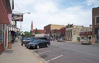
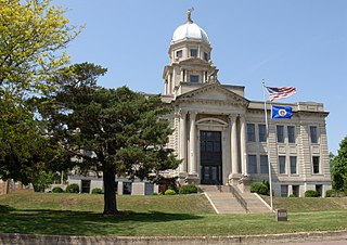
Long Prairie is a town in Todd County, Minnesota, United States. The population was 3,458 at the 2010 census. By the 2020 Decennial Census the population had grown to 3,661. It is the county seat. and the oldest town in the County.

Long Prairie Township is a township in Todd County, Minnesota, United States. The population was 823 at the 2000 census and 884 in the 2020 census.

Round Prairie Township is a township in Todd County, Minnesota, United States. The population was 692 at the 2000 census. By the 2020 census the population had increased to 714 residents.

Stowe Prairie Township is a township in Todd County, Minnesota, United States. The population was 529 at the 2000 census. It had declined to 488 people by the 2020 census.

Turtle Creek Township is a township in Todd County, Minnesota, United States. The population was 323 at the 2000 census and was 270 at the time of the 2020 census.

Villard Township is a township in Todd County, Minnesota, United States. The population was 592 at the 2000 census and was 667 at the time of the 2020 census.

West Union Township is a township in Todd County, Minnesota, United States. The population was 312 at the 2000 census and 254 in the 2020 census. The incorporated village of West Union is within the township of the same name.

References

  1. 1 2 "U.S. Census website". United States Census Bureau . Retrieved January 31, 2008.
  2. "US Board on Geographic Names". United States Geological Survey. October 25, 2007. Retrieved January 31, 2008.
  3. Bureau, US Census. "Minnesota's Population at 5,706,494 in 2020, Up 7.6% Since 2010". Census.gov. Retrieved April 2, 2023.
  4. 1 2 Upham, Warren (1920). Minnesota Geographic Names: Their Origin and Historic Significance. Minnesota Historical Society. p.  546.
  5. "Sculpture". Joseph Kiselewski. Retrieved April 3, 2023.
  6. Downes, James (1976). Todd County Histories (1st ed.). Todd County Bicentennial Committee. p. 82.
  7. Minnesota Atlas & Gazetteer. Yarmouth, Me.: DeLorme. 1994. p. 53. ISBN   0-89933-222-6.
  8. "Horseshoe (77012800) | LakeFinder". Minnesota Department of Natural Resources. Retrieved January 31, 2024.
  9. "Long Prairie River WMA: South Unit". Minnesota Department of Natural Resources. Retrieved February 8, 2024.