Forestville is a ghost town in section 13 of Forestville Township in Fillmore County, Minnesota, United States. The nearest communities are Wykoff, to the northwest, and Preston, to the northeast.
San Francisco is an abandoned townsite in San Francisco Township in Carver County, Minnesota, United States.
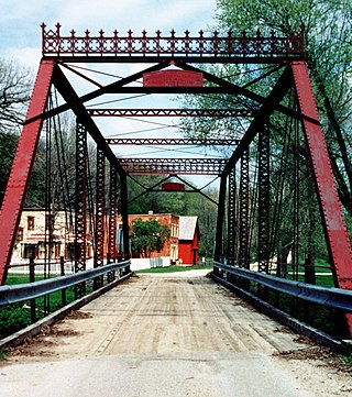
Ashton is an abandoned townsite in sections 11 and 12 of Pleasant Hill Township in Winona County, Minnesota, United States.
Fermoy is an abandoned townsite in McDavitt Township, Saint Louis County, Minnesota, United States. It was located near the communities of Sax and Kelsey. Fermoy was near the intersection of Kolu Road, Cranberry Lane, and Admiral Road South. Saint Louis County Highway 7 is nearby.

Godahl is an unincorporated community in Brown and Watonwan counties in the U.S. state of Minnesota.
Fernando is an unincorporated community in Round Grove Township, McLeod County, Minnesota, United States, near Stewart and Brownton. The community is located near the junction of McLeod County Roads 7 and 17.

Nininger is a ghost town in section 18 of Nininger Township in Dakota County, Minnesota, United States.
Cazenovia is a former populated place in section 21 of Troy Township in Pipestone County, Minnesota, United States.
Craigville is an unincorporated community in Koochiching County, Minnesota, United States; it is located within the Koochiching State Forest.
Grover is an abandoned townsite in section 29 of Fremont Township in Winona County, Minnesota, United States.
Homedahl is an abandoned townsite in sections 29 and 30 of Seely Township in Faribault County, Minnesota, United States.
New Prairie is a ghost town in New Prairie Township in Pope County, Minnesota, United States. It lies between the cities of Cyrus and Starbuck.
Pinewood is a small unincorporated area in section 33 of Buzzle Township in Beltrami County, Minnesota, United States. Some local sources have estimated the area population at 147, however that number cannot be confirmed. It is approximately 19 miles northwest of Bemidji, where most community services are available.
Spina is an abandoned townsite in Great Scott Township, Saint Louis County, Minnesota, United States.
Winner is an abandoned townsite in the former Elkwood Township in southeastern Roseau County, Minnesota, United States.

Leaf River, or Leafriver, is a ghost town in section 22 of Leaf River Township, Wadena County, Minnesota, United States.Today the town has a population around 50. There is a restaurant, a golf course, an old school house and a residential community.
Cedar is a neighborhood of Oak Grove, Anoka County, Minnesota, United States. It was formally absorbed into the city of Oak Grove in 1993. Nearby places include the city of East Bethel. Cedar is located along Cedar Drive, on the south side of Viking Boulevard. Cedar Creek flows nearby.
Rossburg is an unincorporated community in Spencer Township, Aitkin County, Minnesota, United States. The community is located along 350th Avenue near the junction with Aitkin County Road 5, 360th Street. Nearby places include Aitkin, Glen, and Kimberly. State Highway 47 is nearby.
Rabey is an unincorporated community in Aitkin County, Minnesota, United States, within the Savanna State Forest. The community is located between Hill City and Jacobson along State Highway 200 near Rabey Road and Elliot Road. Rabey is located within Northwest Aitkin Unorganized Territory of Aitkin County.
Woodrow is an unincorporated community in Oak Lawn Township, Crow Wing County, Minnesota, United States, near Brainerd. It is along Woodrow Road near Dullum Road.


