Staples Township, Todd County, Minnesota

Last updated

Staples Township, Minnesota
USA Minnesota location map.svg
Red pog.svg
Staples Township, Minnesota
Location within the state of Minnesota
Usa edcp location map.svg
Red pog.svg
Staples Township, Minnesota
Staples Township, Minnesota (the United States)
Coordinates: 46°19′40″N94°49′44″W / 46.32778°N 94.82889°W / 46.32778; -94.82889
Country United States
State Minnesota
County Todd
Area
  Total33.9 sq mi (87.7 km2)
  Land32.7 sq mi (84.7 km2)
  Water1.2 sq mi (3.0 km2)
Elevation
1,286 ft (392 m)
Population
 (2020)
  Total597
  Density19.0/sq mi (7.3/km2)
Time zone UTC-6 (Central (CST))
  Summer (DST) UTC-5 (CDT)
ZIP code
56479
Area code 218
FIPS code 27-62464 [1]
GNIS feature ID0665697 [2]

Staples Township is a township in Todd County, Minnesota, United States. The population was 622 at the 2000 census and in the 2020 census it was 597. [3]

Contents

Staples Township was organized in 1882, and named for Samuel and Isaac Staples, businessmen in the lumber industry. The Staples brothers arrived in Minnesota from Maine and came to Staples via Stillwater, MN. Staples is also a town in the township. Part of the town of Staples are in Todd County and part of it is in Wadena County. [4]

Geography

According to the United States Census Bureau, the township has a total area of 33.9 square miles (87.7 km2); 32.7 square miles (84.7 km2) is land and 1.1 square miles (3.0 km2) (3.40%) is water.

Dower Lake

Dower Lake is an 84 acre lake with a maximum depth of 34 feet. Fish species residing in the lake include black bullhead, black crappie, bluegill, brown bullhead, hybrid sunfish, largemouth bass, northern pike, pumpkinseed, walleye, yellow bullhead, yellow perch, bowfin (dogfish), white sucker, and golden shiner. [5]

Golden Shiner live in the waters of Dower Lake. Notemigonus crysoleucas-1.jpg
Golden Shiner live in the waters of Dower Lake.

Two miles west of the town of Staples, on the shores of Dower Lake, is the 54 acre Dower Lake Recreation Area. The area is owned by the City of Staples and features a softball complex, 9-hole disc golf course, basketball court, swimming beach, sand volleyball court, horseshoe pits, picnic shelter, picnic areas, public lake access and Minnesota’s longest fishing pier, measuring 612 feet. [6]

A few miles northwest of Dower Lake is the Dower Lake Wildlife Management Area, managed by the Minnesota DNR. The 40 acre WMA is open water wetland with surrounding cattails and low land grass and brush areas. [7]

Staples Wildlife Management Area

The American Black Bear lives in the Staples WMA. American black bear (Ursus americanus) - Jasper National Park 02.jpg
The American Black Bear lives in the Staples WMA.

This 1,428.41 acre WMA is in the south eastern corner of the township. Wildlife species in the Staples WMA include Whitetail Deer, Black Bear, Small Game, Forest Upland Birds, Waterfowl, and Wild Turkey. [8]

This Wildlife Management area has grassland and restored wetlandas well as woodlands made up of hardwood and mixed conifer-hardwood trees. [8]

Demographics

As of the census [1] of 2000, there were 622 people, 233 households, and 172 families residing in the township. The population density was 19.0 people per square mile (7.3/km2). There were 274 housing units at an average density of 8.4/sq mi (3.2/km2). The racial makeup of the township was 96.46% White, 0.16% African American, 1.29% Native American, 0.16% Asian, and 1.93% from two or more races. Hispanic or Latino of any race were 1.13% of the population.

There were 233 households, out of which 29.2% had children under the age of 18 living with them, 63.9% were married couples living together, 7.3% had a female householder with no husband present, and 25.8% were non-families. 21.5% of all households were made up of individuals, and 9.4% had someone living alone who was 65 years of age or older. The average household size was 2.67 and the average family size was 3.11.

In the township the population was spread out, with 23.3% under the age of 18, 10.3% from 18 to 24, 24.6% from 25 to 44, 26.5% from 45 to 64, and 15.3% who were 65 years of age or older. The median age was 41 years. For every 100 females, there were 109.4 males. For every 100 females age 18 and over, there were 109.2 males.

The median income for a household in the township was $40,469, and the median income for a family was $47,583. Males had a median income of $28,250 versus $16,827 for females. The per capita income for the township was $15,711. About 5.2% of families and 6.3% of the population were below the poverty line, including 7.5% of those under age 18 and 2.0% of those age 65 or over.

Related Research Articles

<span class="mw-page-title-main">Watonwan County, Minnesota</span> County in Minnesota, United States

Watonwan County is a county in the U.S. state of Minnesota. As of the 2020 census, the population was 11,253. Its county seat is St. James.

<span class="mw-page-title-main">Swift County, Minnesota</span> County in Minnesota, United States

Swift County is a county in the U.S. state of Minnesota. As of the 2020 census, the population was 9,838. Its county seat is Benson.

<span class="mw-page-title-main">Redwood County, Minnesota</span> County in Minnesota, United States

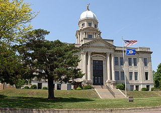
Redwood County is a county in the U.S. state of Minnesota. As of the 2020 census the population was 15,425. Its county seat is Redwood Falls, along the Redwood River near its confluence with the Minnesota River.

<span class="mw-page-title-main">Mahnomen County, Minnesota</span> County in Minnesota, United States

Mahnomen County is a county in the U.S. state of Minnesota. As of the 2020 census, the population was 5,411. Its county seat is Mahnomen.

<span class="mw-page-title-main">Le Sueur County, Minnesota</span> County in Minnesota, United States

Le Sueur County is a county located in the south central portion of the U.S. state of Minnesota. As of the 2020 census, the population was 28,674. Its county seat is Le Center.

<span class="mw-page-title-main">Jackson County, Minnesota</span> County in Minnesota, United States

Jackson County is a county in the U.S. state of Minnesota. As of the 2020 census, the population was 9,989. Its county seat is Jackson.

<span class="mw-page-title-main">Douglas County, Minnesota</span> County in Minnesota, United States

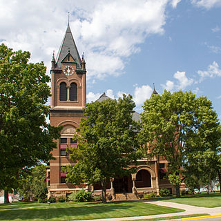
Douglas County is a county in the U.S. state of Minnesota. As of the 2020 census, the population was 39,006. Its county seat is Alexandria.

<span class="mw-page-title-main">Crow Wing County, Minnesota</span> County in Minnesota, United States

Crow Wing County is a county in the East Central part of the U.S. state of Minnesota. As of the 2020 census, the population was 66,123. Its county seat is Brainerd. The county was formed in 1857, and was organized in 1870.

<span class="mw-page-title-main">Cottonwood County, Minnesota</span> County in Minnesota, United States

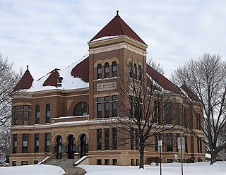
Cottonwood County is a county in the U.S. state of Minnesota. As of the 2020 census, the population was 11,517. Its county seat is Windom.

Lake Eunice Township is a township in Becker County, Minnesota, United States. The population was 1,538 as of the 2010 census.

Kelliher Township is a township in Beltrami County, Minnesota, United States. The population was 150 as of the 2000 census.

Kego Township is a township in Cass County, Minnesota, United States. The population was 465 as of the 2000 census. Kego is a name derived from the Ojibwe language, meaning "fish".

Moose Lake Township is a township in Cass County, Minnesota, United States. The population was 142 as of the 2000 census.

Florence Township is a township in Goodhue County, Minnesota, United States. The population was 1,450 at the 2000 census. A small part of the city of Lake City extends geographically within the township, but is a separate entity. The unincorporated area of Frontenac is also located within the township.

Maxwell Township is a township in Lac qui Parle County, Minnesota, United States. The population was 206 at the 2000 census.

Providence Township is a township in Lac qui Parle County, Minnesota, United States. The population was 186 at the 2000 census.

Turtle Creek Township is a township in Todd County, Minnesota, United States. The population was 323 at the 2000 census and was 270 at the time of the 2020 census.

Villard Township is a township in Todd County, Minnesota, United States. The population was 592 at the 2000 census and was 667 at the time of the 2020 census.

Ward Township is a township in Todd County, Minnesota, United States. The population was 471 at the 2000 census and 474 at the 2020 census.

West Union Township is a township in Todd County, Minnesota, United States. The population was 312 at the 2000 census and 254 in the 2020 census. The incorporated village of West Union is within the township of the same name.

References

  1. 1 2 "U.S. Census website". United States Census Bureau . Retrieved January 31, 2008.
  2. "US Board on Geographic Names". United States Geological Survey. October 25, 2007. Retrieved January 31, 2008.
  3. Bureau, US Census. "Minnesota's Population at 5,706,494 in 2020, Up 7.6% Since 2010". Census.gov. Retrieved April 10, 2023.
  4. Upham, Warren (1920). Minnesota Geographic Names: Their Origin and Historic Significance. Minnesota Historical Society. p.  546.
  5. "Dower (77013800) | LakeFinder". Minnesota Department of Natural Resources. Retrieved February 16, 2024.
  6. "Dower Lake Recreation Area". staples.govoffice.com. Retrieved February 16, 2024.
  7. "Dower Lake WMA". Minnesota Department of Natural Resources. Retrieved February 16, 2024.
  8. 1 2 "Staples WMA". Minnesota Department of Natural Resources. Retrieved February 19, 2024.