Gordon Township, Todd County, Minnesota

Last updated

Gordon Township, Minnesota
USA Minnesota location map.svg
Red pog.svg
Gordon Township, Minnesota
Location within the state of Minnesota
Usa edcp location map.svg
Red pog.svg
Gordon Township, Minnesota
Gordon Township, Minnesota (the United States)
Coordinates: 45°53′16″N95°4′59″W / 45.88778°N 95.08306°W / 45.88778; -95.08306
Country United States
State Minnesota
County Todd
Area
  Total34.9 sq mi (90.4 km2)
  Land27.9 sq mi (72.2 km2)
  Water7.1 sq mi (18.3 km2)
Elevation
1,339 ft (408 m)
Population
 (2020)
  Total659
  Density19.6/sq mi (7.6/km2)
Time zone UTC-6 (Central (CST))
  Summer (DST) UTC-5 (CDT)
FIPS code 27-24578 [1]
GNIS feature ID0664299 [2]

Gordon Township is a township in Todd County, Minnesota, United States. The population was 545 at the 2000 census and 659 in the 2020 census. [3]

Contents

Gordon Township was organized in 1869, and named for farmer J. M. Gordon, who was a member of the first board of Todd County Commissioners. [4]

Geography

According to the United States Census Bureau, the township has a total area of 34.9 square miles (90 km2), of which 27.9 square miles (72 km2) is land and 7.1 square miles (18 km2) (20.19%) is water.

Lake Osakis

This large 6,389 acre lake is partly in Gordon Township and partly in neighboring Douglas County. It has two public boat landings; one on the west side and another on Battle Point Todd County Park on the East side of the Lake. Osakis Lake has a maximum depth of 73 feet. Lake Osakis if the headwaters for the Sauk River and is part of the Sauk River Watershed District.

Logperch live in Lake Osakis. Percina caprodes.jpg
Logperch live in Lake Osakis.

The fish species on the Lake include black bullhead, black crappie, bluegill, brown bullhead, green sunfish, hybrid sunfish, largemouth bass, northern pike, pumpkinseed, rock bass, smallmouth bass, tullibee (cisco), walleye, yellow bullhead, yellow perch, bowfin (dogfish), common carp, shorthead redhorse, white sucker, banded killifish, blackchin shiner, blacknose shiner, bluntnose minnow, brook stickleback, central mudminnow, common shiner, emerald shiner, fathead minnow, golden shiner, Iowa darter, Johnny darter, least darter, logperch, mimic shiner, spottail shiner, and tadpole madtom. [5]

Wildlife Management Area

Yellow Warbler liver in Santer WMA. Dendroica-aestiva-001.jpg
Yellow Warbler liver in Santer WMA.

The 572 acre Santer WildlifeManagement Area is located several miles east of Lake Osakis. The Area is made up of mixed habitat that includes grass fields and restored native grass fields, wetlands, restored wetlands, cattails, low land grass, brush, crop fields, and oak-aspen wooded areas. It is open to the public for a variety of outdoor activities including hunting, photography, and bird watching. [6]

Demographics

As of the census [1] of 2000, there were 545 people, 214 households, and 154 families residing in the township. The population density was 19.6 inhabitants per square mile (7.6/km2). There were 345 housing units at an average density of 12.4 units per square mile (4.8 units/km2). The racial makeup of the township was 97.06% White, 0.18% Native American, 0.92% from other races, and 1.83% from two or more races. Hispanic or Latino of any race were 1.83% of the population.

There were 214 households, out of which 28.0% had children under the age of 18 living with them, 66.8% were married couples living together, 3.3% had a female householder with no husband present, and 28.0% were non-families. 23.8% of all households were made up of individuals, and 8.4% had someone living alone who was 65 years of age or older. The average household size was 2.55 and the average family size was 3.07.

In the township the population was spread out, with 25.5% under the age of 18, 4.6% from 18 to 24, 26.1% from 25 to 44, 25.1% from 45 to 64, and 18.7% who were 65 years of age or older. The median age was 40 years. For every 100 females, there were 108.0 males. For every 100 females age 18 and over, there were 107.1 males.

The median income for a household in the township was $39,531, and the median income for a family was $42,500. Males had a median income of $28,750 versus $18,125 for females. The per capita income for the township was $16,908. About 7.3% of families and 8.6% of the population were below the poverty line, including 10.0% of those under age 18 and 6.5% of those age 65 or over.

Related Research Articles

<span class="mw-page-title-main">Todd County, Minnesota</span> County in Minnesota, United States

Todd County is a county in the central part of the U.S. state of Minnesota. As of the 2020 census, the population was 25,262. Its county seat is Long Prairie.

<span class="mw-page-title-main">Douglas County, Minnesota</span> County in Minnesota, United States

Douglas County is a county in the U.S. state of Minnesota. As of the 2020 census, the population was 39,006. Its county seat is Alexandria.

Lake Eunice Township is a township in Becker County, Minnesota, United States. The population was 1,538 as of the 2010 census.

Minden Township is a township in Benton County, Minnesota, United States. The population was 1,514 as of the 2020 census. Minden Township was organized in 1858.

Sauk Rapids Township is a township in Benton County, Minnesota, United States near the Mississippi River. The population was 584 at the 2010 census.

Osakis Township is a township in Douglas County, Minnesota, United States. The population was 584 at the 2000 census.

Fawn Lake Township is a township in Todd County, Minnesota, United States. The population was 440 at the 2000 census. At the time of the 2020 census the population had increased to 538.

Grey Eagle Township is a township in Todd County, Minnesota, United States. The population was 663 according to a 2000 census and was 556 at the time of the 2020 Census.

Kandota Township is a township in Todd County, Minnesota, United States. The population was 679 at the 2000 census and in the 2020 census it was 805.

Leslie Township is a township in the southwestern corner Todd County, Minnesota, United States. The population was 668 at the 2020 census.

Little Sauk Township is a township in Todd County, Minnesota, United States. The population was 769 at the 2000 census. By the 2020 census the population had grown to 873.

<span class="mw-page-title-main">Long Prairie, Minnesota</span> County seat and city in Minnesota, United States

Long Prairie is a town in Todd County, Minnesota, United States. The population was 3,458 at the 2010 census. By the 2020 Decennial Census the population had grown to 3,661. It is the county seat. and the oldest town in the County.

Round Prairie Township is a township in Todd County, Minnesota, United States. The population was 692 at the 2000 census. By the 2020 census the population had increased to 714 residents.

Staples Township is a township in Todd County, Minnesota, United States. The population was 622 at the 2000 census and in the 2020 census it was 597.

Turtle Creek Township is a township in Todd County, Minnesota, United States. The population was 323 at the 2000 census and was 270 at the time of the 2020 census.

Ward Township is a township in Todd County, Minnesota, United States. The population was 471 at the 2000 census and 474 at the 2020 census.

West Union Township is a township in Todd County, Minnesota, United States. The population was 312 at the 2000 census and 254 in the 2020 census. The incorporated village of West Union is within the township of the same name.

<span class="mw-page-title-main">Sauk Centre, Minnesota</span> City in Minnesota, United States

Sauk Centre is a city in Stearns County, Minnesota, United States. The population was 4,555 at the 2020 census. Sauk Centre is part of the St. Cloud Metropolitan Statistical Area.

Bruce Township is a township in Todd County, Minnesota, United States. The population was 564 at the 2000 census but had declined to 479 by the 2020 census.

<span class="mw-page-title-main">Osakis, Minnesota</span> City in Minnesota, United States

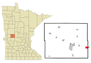
Osakis is a city in Douglas and Todd counties in the U.S. state of Minnesota. The population was 1,771 at the 2020 census.

References

  1. 1 2 "US Census website". United States Census Bureau . Retrieved January 31, 2008.
  2. "US Board on Geographic Names". United States Geological Survey. October 25, 2007. Retrieved January 31, 2008.
  3. Bureau, US Census. "Minnesota's Population at 5,706,494 in 2020, Up 7.6% Since 2010". Census.gov. Retrieved April 2, 2023.
  4. Upham, Warren (1920). Minnesota Geographic Names: Their Origin and Historic Significance. Minnesota Historical Society. p.  544.
  5. "Osakis (77021500) | LakeFinder". Minnesota Department of Natural Resources. Retrieved May 24, 2024.
  6. "Santer WMA". Minnesota Department of Natural Resources. Retrieved May 25, 2024.