Kandota Township, Todd County, Minnesota

Last updated

Kandota Township, Minnesota
USA Minnesota location map.svg
Red pog.svg
Kandota Township, Minnesota
Location within the state of Minnesota
Usa edcp location map.svg
Red pog.svg
Kandota Township, Minnesota
Kandota Township, Minnesota (the United States)
Coordinates: 45°48′43″N94°56′54″W / 45.81194°N 94.94833°W / 45.81194; -94.94833
Country United States
State Minnesota
County Todd
Area
  Total24.2 sq mi (62.6 km2)
  Land21.8 sq mi (56.4 km2)
  Water2.4 sq mi (6.1 km2)
Elevation
1,289 ft (393 m)
Population
 (2020)
  Total805
  Density31.2/sq mi (12.0/km2)
Time zone UTC-6 (Central (CST))
  Summer (DST) UTC-5 (CDT)
FIPS code 27-32408 [1]
GNIS feature ID0664598 [2]

Kandota Township is a township in Todd County, Minnesota, United States. The population was 679 at the 2000 census and in the 2020 census it was 805. [3]

Contents

Kandota Township was organized in April 1870 and it took the name of a town site that had been proposed and platted in 1856. The site, which was on the shore of Fairy Lake, never developed into a town although it did have a Great Northern Railway station. It was the first town site platted in Todd County. [4]

Geography

According to the United States Census Bureau, the township has a total area of 24.1 square miles (62 km2), of which 21.8 square miles (56 km2) is land and 2.4 square miles (6.2 km2) (9.81%) is water. [5]

Lakes

Kandota township has a number of lakes including Lily, Long, and Fairy. The three form a chain wit Fairy, at 306 acres is the largest. Fairy has a maximum depth of 37 feet and a mean depth of 16.5 feet. The lake as a public boat landing on thenorth east corner. [5]

The Central Mudminnow lives in Fairy Lake. FMIB 35951 Mud Minnow (Umbra limi).jpeg
The Central Mudminnow lives in Fairy Lake.

The fish species in Fairy Lake include black bullhead, black crappie, bluegill, brown bullhead, green sunfish, hybrid sunfish, largemouth bass, northern pike, pumpkinseed, smallmouth bass, tullibee (cisco), walleye, yellow bullhead, yellow perch, bowfin (dogfish), common carp, white sucker, banded killifish, blackchin shiner, blacknose shiner, bluntnose minnow, central mudminnow, Iowa darter, Johnny darter, and spottail shiner. [5]

The Sauk River flows through Kandota township several miles south of Fairy Lake.

Demographics

As of the census [1] of 2000, there were 679 people, 237 households, and 188 families residing in the township. The population density was 31.2 inhabitants per square mile (12.0/km2). There were 323 housing units at an average density of 14.8 per square mile (5.7/km2). The racial makeup of the township was 99.71% White, 0.15% Asian, 0.15% from other races. Hispanic or Latino of any race were 0.44% of the population.

There were 237 households, out of which 36.7% had children under the age of 18 living with them, 73.4% were married couples living together, 3.4% had a female householder with no husband present, and 20.3% were non-families. 16.5% of all households were made up of individuals, and 3.8% had someone living alone who was 65 years of age or older. The average household size was 2.84 and the average family size was 3.22.

In the township the population was spread out, with 29.6% under the age of 18, 6.6% from 18 to 24, 24.7% from 25 to 44, 26.7% from 45 to 64, and 12.4% who were 65 years of age or older. The median age was 38 years. For every 100 females, there were 107.6 males. For every 100 females age 18 and over, there were 111.5 males.

The median income for a household in the township was $43,750, and the median income for a family was $49,583. Males had a median income of $31,705 versus $21,607 for females. The per capita income for the township was $17,798. About 2.7% of families and 6.9% of the population were below the poverty line, including 8.8% of those under age 18 and none of those age 65 or over.

Related Research Articles

<span class="mw-page-title-main">Le Sueur County, Minnesota</span> County in Minnesota, United States

Le Sueur County is a county located in the south central portion of the U.S. state of Minnesota. As of the 2020 census, the population was 28,674. Its county seat is Le Center.

Lake Eunice Township is a township in Becker County, Minnesota, United States. The population was 1,538 as of the 2010 census.

Sugar Bush Township is a township in Becker County, Minnesota, United States. The population was 537 as of the 2000 census.

Kelliher Township is a township in Beltrami County, Minnesota, United States. The population was 150 as of the 2000 census.

Becker Township is a township in Cass County, Minnesota, United States. The population was 485 as of the 2000 census. Becker Township was named for J. A. Becker, a pioneer settler.

Kego Township is a township in Cass County, Minnesota, United States. The population was 465 as of the 2000 census. Kego is a name derived from the Ojibwe language, meaning "fish".

Bay Lake Township is a township in Crow Wing County, Minnesota, United States. The population was 923 at the 2000 census. This township took its name from Bay Lake.

<span class="mw-page-title-main">Garrison, Minnesota</span> City in Minnesota, United States

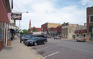
Garrison is a city in Crow Wing County, Minnesota, United States, along Mille Lacs Lake. The population was 210 at the 2010 census. It is part of the Brainerd Micropolitan Statistical Area. U.S. Highway 169 and Minnesota State Highway 18 are the main routes in the community.

<span class="mw-page-title-main">Waterville, Minnesota</span> City in Minnesota, United States

Waterville is a town in Le Sueur County, Minnesota, United States. The population was 1,868 at the 2010 census. It is close to Sakatah Lake State Park on the Cannon River.

<span class="mw-page-title-main">Flensburg, Minnesota</span> City in Minnesota, United States

Flensburg is a city in Morrison County, Minnesota, United States. The population was 216 at the 2020 census.

Le Roy Township is a township in Mower County, Minnesota, United States. The population was 396 at the 2000 census. The town in the township with the largest population is Le Roy with 925 people. The township is also home to Lake Louise State Park, the only Minnesota State Park in Mower County and the southernmost in the state. The Old Village of Le Roy was the first area in the township to be settled.

<span class="mw-page-title-main">Vergas, Minnesota</span> City in Minnesota, United States

Vergas is a city in northern Otter Tail County, Minnesota, United States. The population was 348 at the 2020 census.

Lake George Township is a township in Stearns County, Minnesota, United States. The population was 335 at the 2010 census.

<span class="mw-page-title-main">Long Prairie, Minnesota</span> County seat and city in Minnesota, United States

Long Prairie is a town in Todd County, Minnesota, United States. The population was 3,458 at the 2010 census. By the 2020 Decennial Census the population had grown to 3,661. It is the county seat. and the oldest town in the County.

Round Prairie Township is a township in Todd County, Minnesota, United States. The population was 692 at the 2000 census. By the 2020 census the population had increased to 714 residents.

Staples Township is a township in Todd County, Minnesota, United States. The population was 622 at the 2000 census and in the 2020 census it was 597.

Turtle Creek Township is a township in Todd County, Minnesota, United States. The population was 323 at the 2000 census and was 270 at the time of the 2020 census.

Ward Township is a township in Todd County, Minnesota, United States. The population was 471 at the 2000 census and 474 at the 2020 census.

West Union Township is a township in Todd County, Minnesota, United States. The population was 312 at the 2000 census and 254 in the 2020 census. The incorporated village of West Union is within the township of the same name.

Birchdale Township is a township in Todd County, Minnesota, United States. The population was 814 at the 2000 census and grew to 931 for the 2020 census.

References

  1. 1 2 "U.S. Census website". United States Census Bureau . Retrieved January 31, 2008.
  2. "US Board on Geographic Names". United States Geological Survey. October 25, 2007. Retrieved January 31, 2008.
  3. Bureau, US Census. "Minnesota's Population at 5,706,494 in 2020, Up 7.6% Since 2010". Census.gov. Retrieved April 10, 2023.
  4. Upham, Warren (1920). Minnesota Geographic Names: Their Origin and Historic Significance. Minnesota Historical Society. p.  545.
  5. 1 2 3 "Fairy (77015400) | LakeFinder". Minnesota Department of Natural Resources. Retrieved March 5, 2024.