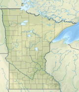
The Adirondack High Peaks are a set of 46 mountain peaks in the Adirondack Mountains of New York state. They have been popular hiking destinations since the late 1920s, when the list of peaks was published in Russell Carson's book Peaks and Peoples of the Adirondacks. Those who have climbed all 46 High Peaks are eligible to join the Adirondack Forty-Sixers club.

Black Elk Peak, formerly known as Harney Peak, is the highest natural point in the U.S. state of South Dakota and the Midwestern United States. It lies in the Black Elk Wilderness area, in southern Pennington County, in the Black Hills. The peak lies 3.7 mi (6.0 km) west-southwest of Mount Rushmore. At 7,244 feet (2,208 m), it is the highest summit in the United States east of the Rocky Mountains. Though part of the North American Cordillera, it is generally considered to be geologically separate from the Rocky Mountains.

The Wenatchee Mountains are a range of mountains in central Washington State, United States of America. A major subrange of the Cascade Range, extending east 50 miles (80 km) from the Cascade crest, the Wenatchee Mountains separate the drainage basins of the Yakima River from the Wenatchee River. The crest of the range forms part of the boundary between Chelan and Kittitas Counties.

The Taconic Mountains are a 150-mile-long sub-range of the Appalachian Mountains lying on the eastern border of New York State and adjacent New England. The range, which played a role in the history of geological science, is separated from the Berkshires and Green Mountains to the east by a series of valleys, principally those of the Housatonic River, Battenkill River and Otter Creek. The Taconics' highest point is Mount Equinox in Vermont at 3,840 feet (1,170 m); among many other summits are Dorset Mountain, Mount Greylock and Mount Everett.
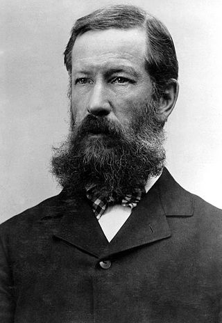
Henry Gannett was an American geographer who is described as the "father of mapmaking in America." He was the chief geographer for the United States Geological Survey essentially from its founding until 1902.

Beacon Mountain, locally Mount Beacon, is the highest peak of Hudson Highlands, located south of City of Beacon, New York, in the Town of Fishkill. Its two summits rise above the Hudson River behind the city and can easily be seen from Newburgh across the river and many other places in the region. The more accessible northern peak, at 1,516 feet (462 m) above sea level, has a complex of radio antennas on its summit; the 1,595 feet (486 m) southern summit has a fire lookout tower, which was built in 1931.

Eagle Peak is a mountain in the Absaroka Range in the U.S. state of Wyoming and at 11,372 feet (3,466 m) is the highest point in Yellowstone National Park. It is located about 6 miles (9.7 km) east of the southeast arm of Yellowstone Lake.

Hadley Mountain is a mountain located in the southern Adirondacks in the U.S. state of New York and is the second-highest peak in Saratoga County after neighboring Tenant Mountain. The Hadley Mountain Fire Observation Station was listed on the National Register of Historic Places on September 23, 2001 for its role as a Fire lookout tower with the New York State Forest Preserve. Hadley Mountain is the highest of the three peaks that form the West Mountain ridge.

Hurricane Mountain is a 3,688-foot-tall (1,124 m) mountain near Keene in the north of the High Peaks region of the Adirondacks in New York, United States. It is considered to boast some of the most impressive views of any of the lesser peaks; this is due to its prominence, and because its summit was cleared by Verplanck Colvin in the course of his early survey of the Adirondacks. On a clear day, the length of Lake Champlain and the Green Mountains of Vermont are visible to the east, and many of the High Peaks can be seen to the south through the northwest. There is a disused fire tower on the top.

Mount Holmes is a prominent mountain peak in Yellowstone National Park. It is the tallest mountain in the Wyoming portion of the Gallatin Range. Mount Holmes is located in the northwestern part of the park and marks the southern terminus of the Gallatin Range. It is the source of Indian Creek, a tributary of the Gardner River.

Blue Mountain is a peak in the Adirondack Mountains of New York State in the United States. Located east of Blue Mountain Lake, Hamilton County, the peak reaches a height of 3,750 ft (1,140 m). For hiking, the elevation gain is 1,559 feet and the trail length is four miles. The trailhead elevation is 2,200 feet. It is the location of the Blue Mountain Fire Observation Station, listed on the National Register of Historic Places in 2001.
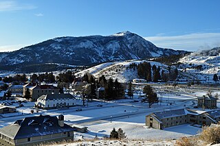
Bunsen Peak el. 8,564 feet (2,610 m) is a prominent peak due south of Mammoth Hot Springs in Yellowstone National Park, Wyoming. The peak lies on the east flank of Kingman Pass on the Mammoth to Norris section of the Grand Loop Road. The peak was first ascended by Ferdinand V. Hayden and Captain John W. Barlow in 1871, Bunsen Peak was not named until 1872 during the second Hayden Geologic Survey. E. S. Topping named the peak Observation Mountain in 1872 as well, but that name did not stick. The Bunsen Peak Trail with its trailhead just south of Mammoth is a steep 2.1 miles (3.4 km) to the summit. Bunsen Peak was named for the German chemist Robert Bunsen, the inventor of the Bunsen Burner and responsible for early work on volcanic geyser theories.
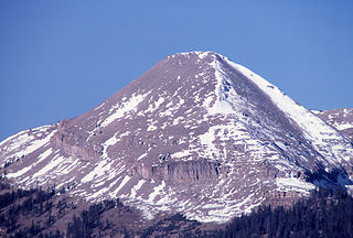
Antler Peak, el. 10,063 feet (3,067 m) is a prominent mountain peak in the Gallatin Range in Yellowstone National Park. The peak was originally named Bell's Peak in honor of an Assistant Secretary of the Interior by either Philetus Norris, the second park superintendent or W.H.Holmes, a U.S. Geological Survey geologist in 1878. However, in 1885, Arnold Hague of the U.S. Geological Survey renamed the peak Antler Peak because of the numerous shed elk and deer antlers found on its slopes.

Abiathar Peak is a mountain peak with an elevation of 10,928 feet (3,331 m) in the northeastern section of Yellowstone National Park, in the Absaroka Range of the U.S. state of Wyoming. It sits across and east of its better known neighbor, Barronette Peak. The peak was named by members of the 1885 Hague Geological Survey to honor Charles Abiathar White, a geologist and paleontologist who had participated in early western geological surveys. White never visited Yellowstone.
Mount Chittenden, elevation 10,182 feet (3,103 m), is a mountain peak in the Absaroka Range in Yellowstone National Park. The peak was named by Henry Gannett of the Hayden Geological Survey of 1878 for George B. Chittenden, a surveyor who had worked with Gannett, Hayden and others in surveys in Montana, Idaho and Wyoming. Chittenden never participated in any of the Yellowstone surveys.

Bearfort Mountain, historically known as Bear Ford Mountain, is a mountain ridge extending from Wawayanda State Park northward through Abram S. Hewitt State Forest in West Milford, Passaic County, New Jersey. It is a continuation of Bellvale Mountain in New York. The Appalachian Trail crosses along the ridge into New York. Puddingstone of the Skunnemunk Conglomerate is visible along the ridge.
Bramley Mountain is a mountain located in the Catskill Mountains of New York located south of Bloomville and east-northeast of Delhi. Bovina Mountain is located northeast of Bramley Mountain.

Goodnow Mountain is a 2,664-foot-tall (812 m) peak in the Adirondack Mountains of New York in the United States. It is the location of the Goodnow Mountain Fire Observation Station. In 1922, the Civilian Conservation Corps built a 60-foot-tall fire tower on the mountain. The tower closed at the end of the 1979 season. The tower was later transferred to SUNY College of Forestry and is now open to the public.

Kempshall Mountain is a 3,350-foot-tall (1,020 m) mountain located in Adirondack Mountains of New York. It is located in the northwest of the hamlet of Long Lake in Hamilton County. In 1918, a 35-foot-tall (11 m) Aermotor LS40 tower was built on the mountain for fire lookout purposes. Due to aerial detection being used, the tower ceased fire lookout operations at the end of the 1971 season. The tower was later removed, and portions of the tower along with the tower from West Mountain were used to build the tower that is at the Essex County Historical Museum in Elizabethtown.