Pine River Township is a township in Cass County, Minnesota, United States. The population was 1,061 as of the 2000 census. This township took its name from the Pine River.
Powers Township is a township in Cass County, Minnesota, United States. The population was 918 at the 2000 census. Powers Township was named for Gorham Powers, a Minnesota politician who owned land there.
Leaf Mountain Township is a township in Otter Tail County, Minnesota, United States. The population was 309 at the 2000 census.

Great Scott Township is a township in Saint Louis County, Minnesota, United States. The population was 561 at the 2010 census.
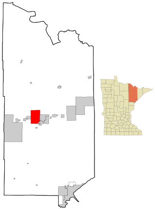
Mountain Iron is a city in Saint Louis County, Minnesota, United States, in the heart of the Mesabi Range. The population was 2,878 at the 2020 census.
Wuori Township is a township in Saint Louis County, Minnesota, United States. The population was 572 at the 2010 census.

Minnesota Glacier is a broad glacier, about 40 nautical miles long and 5 nautical miles wide, flowing east through the Ellsworth Mountains in Antarctica, separating the Sentinel Range and the Heritage Range. It is nourished by ice from the plateau west of the mountains and by Nimitz Glacier and Splettstoesser Glacier, and merges into the larger Rutford Ice Stream at the eastern margin of the Ellsworth Mountains.
The Jones Mountains are an isolated group of mountains, trending generally east–west for 27 nautical miles, situated on the Eights Coast, Ellsworth Land, Antarctica, about 50 nautical miles south of Dustin Island.

Eagle Mountain is the highest natural point in Minnesota, United States, at 2,301 feet (701 m). It is in northern Cook County in the Boundary Waters Canoe Area Wilderness and Superior National Forest in the Misquah Hills, northwest of Grand Marais. It is a Minnesota State Historic Site.

Disappointment Peak is in the Teton Range of Wyoming, in Grand Teton National Park and immediately southeast of Grand Teton. The peak is part of the Cathedral Group, a region of the Tetons noted for particularly rugged mountains. Disappointment Peak rises to the north of Garnet Canyon and to the west of Amphitheater and Surprise lakes. The peak has a variety of mountaineering routes, including the most difficult in the range.
Munger is an unincorporated community in Solway Township, Saint Louis County, Minnesota, United States.
Wolf is an unincorporated community in Clinton Township, Saint Louis County, Minnesota, United States.
Costin Village is a former townsite at the location of what is now the city of Mountain Iron, Minnesota. Costin Village was founded by John Costin. Its population in the year 1907 was 1,000 people.
Greenwood Mountain is the name of several mountain summits in the United States.
Jasper Peak is a peak in northeastern Minnesota near Soudan. It derives its current name from the red jasper which is the major constituent of the mountain's bedrock. A Minnesota Division of Forestry lookout tower built in 1934 is situated on the summit.

Leaf River, or Leafriver, is a ghost town in section 22 of Leaf River Township, Wadena County, Minnesota, United States.Today the town has a population around 50. There is a restaurant, a golf course, an old school house and a residential community.

Gowan Glacier is a glacier about 15 nautical miles long in the Heritage Range of the Ellsworth Mountains of Antarctica, flowing north from the vicinity of Cunningham Peak in the Founders Escarpment to enter Minnesota Glacier just east of Welcome Nunatak. It was mapped by the United States Geological Survey from surveys and U.S. Navy air photos, 1961–66, and was named by the Advisory Committee on Antarctic Names for Lieutenant Jimmy L. Gowan, U.S. Navy Medical Corps, officer in charge and doctor at Plateau Station in 1966.

Hudman Glacier is a glacier draining south of Mount Landolt between Marze Peak and Miller Peak in Petvar Heights at the south end of the Sentinel Range, in the Ellsworth Mountains of Antarctica, flowing south-southeast to Minnesota Glacier. It was mapped by the United States Geological Survey from surveys and U.S. Navy air photos, 1957–59, and was named by the Advisory Committee on Antarctic Names for Captain Rayburn A. Hudman, United States Marine Corps, who died in the crash of a Lockheed P2V-2n Neptune, modified for extreme range, flying in sub zero temperatures and Ski equipped for landing on the Ice runways at McMurdo Sound Antarctica on 18 October 1956.
West Virginia is a neighborhood of Mountain Iron, Saint Louis County, Minnesota, United States. It was formally absorbed into the city of Mountain Iron in the 1970s.