
Cook County is the easternmost county in the U.S. state of Minnesota. As of the 2020 census, the population was 5,600, making it Minnesota's seventh-least populous county. Its county seat is Grand Marais. The Grand Portage Indian Reservation is in the county.
Powers Township is a township in Cass County, Minnesota, United States. The population was 918 at the 2000 census. Powers Township was named for Gorham Powers, a Minnesota politician who owned land there.
Godfrey Township is a township in Polk County, Minnesota, United States. It is part of the Grand Forks-ND-MN Metropolitan Statistical Area. The population was 327 at the 2000 census.
Portageville is a hamlet located in the town of Genesee Falls in Wyoming County, New York, United States. Its name derives from the Native American canoeists who would withdraw their craft from the river to avoid going over three waterfalls in the Genesee River gorge now known as Portage Falls. They had to portage several miles to the site of present-day Mount Morris, where they could embark for the rest of the journey downriver.

Wilmore is a borough in Cambria County, Pennsylvania, United States. It is part of the Johnstown, Pennsylvania Metropolitan Statistical Area. The population was 225 at the 2010 census.
Grand Portage is an unorganized territory in Cook County, Minnesota, United States, on Lake Superior, at the northeastern corner of the state near the border with northwestern Ontario. The population was 616 at the 2020 census. The unincorporated community of Grand Portage and the Grand Portage Indian Reservation are both located within Grand Portage Unorganized Territory of Cook County.
The Chugach Mountains of southern Alaska are the northernmost of the several mountain ranges that make up the Pacific Coast Ranges of the western edge of North America. The range is about 250 miles (402 km) long and 60 miles (97 km) wide, and extends from the Knik and Turnagain Arms of the Cook Inlet on the west to Bering Glacier, Tana Glacier, and the Tana River on the east. It is bounded on the north by the Matanuska, Copper, and Chitina rivers. The highest point of the Chugach Mountains is Mount Marcus Baker, at 13,094 feet (3,991 m), but with an average elevation of 4,006 feet (1,221 m), most of its summits are not especially high. Even so, its position along the Gulf of Alaska ensures more snowfall in the Chugach than anywhere else in the world, an annual average of over 1500 cm (800 in).

The Pigeon River forms part of the Canada–United States border between the state of Minnesota and the province of Ontario, west of Lake Superior. In pre-industrial times, the river was a waterway of great importance for transportation and the fur trade.

Grand Portage National Monument is a United States National Monument located on the north shore of Lake Superior in northeastern Minnesota that preserves a vital center of fur trade activity and Anishinaabeg Ojibwe heritage. The area became one of the British Empire's four main fur trading centers in North America, along with Fort Niagara, Fort Detroit, and Michilimackinac.

The Treaty of La Pointe may refer to either of two treaties made and signed in La Pointe, Wisconsin between the United States and the Ojibwe (Chippewa) Native American peoples. In addition, the Isle Royale Agreement, an adhesion to the first Treaty of La Pointe, was made at La Pointe.

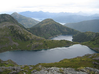
Grand Portage State Park is a state park at the northeastern tip of the U.S. state of Minnesota, on the Canada–United States border. It contains a 120-foot (37 m) waterfall, the tallest in the state, on the Pigeon River. The High Falls and other waterfalls and rapids upstream necessitated a historically important portage on a fur trade route between the Great Lakes and inland Canada. This 8.5-mile (13.7 km) path as well as the sites of historic forts at either end are preserved in nearby Grand Portage National Monument.

Jay Cooke State Park is a state park of Minnesota, United States, protecting the lower reaches of the Saint Louis River. The park is located about 10 miles (16 km) southwest of Duluth and is one of the ten most visited state parks in Minnesota. The western half of the park contains part of a rocky, 13-mile (21 km) gorge. This was a major barrier to Native Americans and early Europeans traveling by canoe, which they bypassed with the challenging Grand Portage of the St. Louis River. The river was a vital link connecting the Mississippi waterways to the west with the Great Lakes to the east.

Mount Jo is a 2,832-foot-tall (863 m) mountain in the heart of the Adirondack Mountains of New York. It is in North Elba, New York on land owned by the Adirondack Mountain Club. The Adirondack Loj and Heart Lake are at the foot of Mount Jo. There are two trails that lead to its summit.
Hovland is an unincorporated community in Cook County, Minnesota, United States.
Lutsen is an unincorporated community and census-designated place (CDP) in Lutsen Township, Cook County, Minnesota, United States. As of the 2020 census, its population was 220.
Pigeon River is an unincorporated community in Cook County, Minnesota, United States; located four miles north of the community of Grand Portage.
Pigeon Point is an isolated peninsula located at the northeast extremity of Minnesota, in Cook County, Minnesota, United States. To the north of the point lies Pigeon Bay, which shares a shoreline with Canada, and to the south is Lake Superior. Pigeon Point is the closest mainland U.S. point to Isle Royale, on the far side of the water boundary between Minnesota and Michigan. The extreme end of the point is owned by the United States Coast Guard while the land up to the point is held by the Grand Portage Indian Reservation. The settlement closest to the point is Grand Portage, Minnesota which lies thirteen miles to the west. There are no roads that lead out to the point, which is only accessible on foot or by boat.
Mineral Center is an unincorporated community in Cook County, Minnesota, United States; located five miles west of the community of Grand Portage.
Grand Portage is an unincorporated community in Cook County, Minnesota, United States; located on Grand Portage Bay of the North Shore of Lake Superior.
Colvill is an extinct townsite in Cook County, Minnesota, United States.

