Isle Royale National Park is a national park of the United States consisting of Isle Royale, along with more than 400 small adjacent islands and the surrounding waters of Lake Superior, in Michigan.

Grand Marais is a city and the county seat of Cook County, Minnesota, United States, of which it is the only municipality. It is on Lake Superior's North Shore. Grand Marais had a population of 1,337 at the 2020 census. Before it was settled by French Canadians and before Minnesota's statehood, it was inhabited by the Ojibwe.
Grand Portage is an unorganized territory in Cook County, Minnesota, United States, on Lake Superior, at the northeastern corner of the state near the border with northwestern Ontario. The population was 616 at the 2020 census. The unincorporated community of Grand Portage and the Grand Portage Indian Reservation are both located within Grand Portage Unorganized Territory of Cook County.

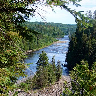
The Pigeon River forms part of the Canada–United States border between the state of Minnesota and the province of Ontario, west of Lake Superior. In pre-industrial times, the river was a waterway of great importance for transportation and the fur trade.

The Boundary Waters Canoe Area Wilderness comprises 1,090,000 acres (440,000 ha) of pristine forests, glacial lakes, and streams in the Superior National Forest. Located entirely within the U.S. state of Minnesota at the Boundary Waters, the wilderness area is under the administration of the United States Forest Service. Efforts to preserve the primitive landscape began in the 1900s and culminated in the Boundary Waters Canoe Area Wilderness Act of 1978. The area is a popular destination for canoeing, hiking, and fishing, and is the most visited wilderness in the United States.
The Kaministiquia River is a river which flows into western Lake Superior at the city of Thunder Bay, Ontario. Kaministiquia is an Ojibwe word meaning "where a stream flows in island" due to two large islands at the mouth of the river. The delta has three branches or outlets, reflected on early North American maps in French as "les trois rivières" : the southernmost is known as the Mission River, the central branch as the McKellar River, and the northernmost branch as the Kaministiquia. Residents of the region commonly refer to the river as the Kam River.
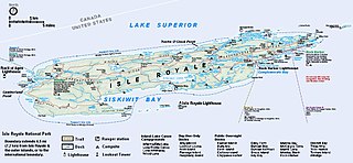
Isle Royale is an island of the Great Lakes located in the northwest of Lake Superior and part of the U.S. state of Michigan. The island and the 450 surrounding smaller islands and waters make up Isle Royale National Park.
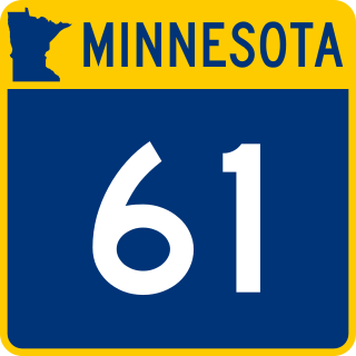
Minnesota State Highway 61 is a 150.321-mile-long (241.918 km) highway in northeast Minnesota, which runs from a junction with Interstate 35 (I-35) in Duluth at 26th Avenue East, and continues northeast to its northern terminus at the Canadian border near Grand Portage, connecting to Ontario Highway 61 at the Pigeon River Bridge. The route is a scenic highway, following the North Shore of Lake Superior, and is part of the Lake Superior Circle Tour designation that runs through Minnesota, Ontario, Michigan, and Wisconsin.

The Boundary Waters, also called the Quetico-Superior Country, is a region of wilderness straddling the Canada–United States border between Ontario and Minnesota, in the area just west of Lake Superior. While "Boundary Waters" is a common name for this region, the two nations also share extensive boundary waters along their border, beyond this region. This region is part of the Superior National Forest in northeastern Minnesota, and in Canada it includes La Verendrye and Quetico Provincial Parks in Ontario. Voyageurs National Park in Minnesota may also be considered part of the Boundary Waters. The name "Boundary Waters" is often used in the U.S. to refer specifically to the U.S. Wilderness Area protecting its southern extent, the Boundary Waters Canoe Area Wilderness.
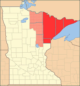
The Arrowhead Region is located in the northeastern part of the U.S. state of Minnesota, so called because of its pointed shape. The predominantly rural region encompasses 10,635.26 square miles (27,545.2 km2) of land area and includes Carlton, Cook, Lake and Saint Louis counties. Its population at the 2000 census was 248,425 residents. The region is loosely defined, and Aitkin, Itasca, and Koochiching counties are sometimes considered as part of the region, increasing the land area to 18,221.97 square miles (47,194.7 km2) and the population to 322,073 residents. Primary industries in the region include tourism and iron mining.

Cumberland House is a community in Census Division No. 18 in northeast Saskatchewan, Canada on the Saskatchewan River. It is the oldest community in Saskatchewan and has a population of about 2,000 people. Cumberland House Provincial Park, which provides tours of an 1890s powder house built by the Hudson's Bay Company, is located nearby.

Savanna Portage State Park is a state park in the U.S. State of Minnesota established in 1961 to preserve the historic Savanna Portage, a difficult 6-mile (9.7 km) trail connecting the watersheds of the Mississippi River and Lake Superior. The portage trail crosses a drainage divide separating the West Savanna River, which drains to the Mississippi River and the Gulf of Mexico, from the East Savanna River, which flows in an opposite direction to the Saint Louis River, Lake Superior and the Great Lakes, and the Saint Lawrence River to the Atlantic Ocean.

Grand Portage National Monument is a United States National Monument located on the north shore of Lake Superior in northeastern Minnesota that preserves a vital center of fur trade activity and Anishinaabeg Ojibwe heritage. The area became one of the British Empire's four main fur trading centers in North America, along with Fort Niagara, Fort Detroit, and Michilimackinac.

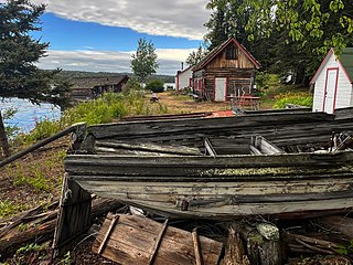
Rock Harbor is the main access point for visitors landing on Isle Royale in northern Lake Superior. It sits four miles (6.4 km) from the northeastern end of the 45-mile-long (72 km) island, the whole of which is protected as Isle Royale National Park. Two structures in Rock Harbor—the Rock Harbor Light and the Edisen Fishery—are listed on the National Register of Historic Places.

Grand Portage State Park is a state park at the northeastern tip of the U.S. state of Minnesota, on the Canada–United States border. It contains a 120-foot (37 m) waterfall, the tallest in the state, on the Pigeon River. The High Falls and other waterfalls and rapids upstream necessitated a historically important portage on a fur trade route between the Great Lakes and inland Canada. This 8.5-mile (13.7 km) path as well as the sites of historic forts at either end are preserved in nearby Grand Portage National Monument.

Jay Cooke State Park is a state park of Minnesota, United States, protecting the lower reaches of the Saint Louis River. The park is located about 10 miles (16 km) southwest of Duluth and is one of the ten most visited state parks in Minnesota. The western half of the park contains part of a rocky, 13-mile (21 km) gorge. This was a major barrier to Native Americans and early Europeans traveling by canoe, which they bypassed with the challenging Grand Portage of the St. Louis River. The river was a vital link connecting the Mississippi waterways to the west with the Great Lakes to the east.
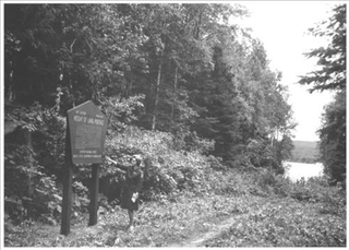
Height of Land Portage is a portage along the historic Boundary Waters route between Canada and the United States. Located at the border of the Canadian province of Ontario and the U.S. state of Minnesota, the path is a relatively easy crossing of the Laurentian Divide separating the Hudson Bay and Great Lakes-St. Lawrence watersheds.
Lutsen is an unincorporated community and census-designated place (CDP) in Lutsen Township, Cook County, Minnesota, United States. As of the 2020 census, its population was 220.

This article covers the water based Canadian canoe routes used by early explorers of Canada with special emphasis on the fur trade.
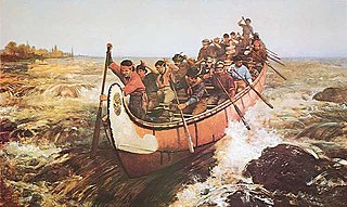
Voyageurs were 18th- and 19th-century French and later French Canadians and others who transported furs by canoe at the peak of the North American fur trade. The emblematic meaning of the term applies to places and times where that transportation was over long distances, giving rise to folklore and music that celebrated voyageurs' strength and endurance. They traversed and explored many regions in what is now Canada and the United States.


