
Pembina County is a county in the U.S. state of North Dakota. At the 2020 census its population was 6,844. The county seat is Cavalier.

Riverton is a city in Crow Wing County, Minnesota, United States. The population was 117 at the 2010 census. It is part of the Brainerd Micropolitan Statistical Area.

Chippewa Falls is a city located on the Chippewa River in Chippewa County, Wisconsin, United States. The population was 14,731 in the 2020 census. Incorporated as a city in 1869, it is the county seat of Chippewa County.

Sartell is a city in Benton and Stearns Counties in the U.S. state of Minnesota that straddles the Mississippi River. It is part of the St. Cloud Metropolitan Statistical Area. The population was 19,351 at the 2020 census, making it St. Cloud's most populous suburb and the fourth-largest city in central Minnesota, after St. Cloud, Elk River, and Willmar.
Grand Portage is an unorganized territory in Cook County, Minnesota, United States, on Lake Superior, at the northeastern corner of the state near the border with northwestern Ontario. The population was 616 at the 2020 census. The unincorporated community of Grand Portage and the Grand Portage Indian Reservation are both located within Grand Portage Unorganized Territory of Cook County.
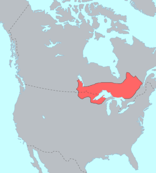
The Ojibwe are an Anishinaabe people whose homeland covers much of the Great Lakes region and the northern plains, extending into the subarctic and throughout the northeastern woodlands. The Ojibwe, being Indigenous peoples of the Northeastern Woodlands and of the subarctic, are known by several names, including Ojibway or Chippewa. As a large ethnic group, several distinct nations also consider themselves Ojibwe, including the Saulteaux, Nipissings, and Oji-Cree.

The Red Lake Indian Reservation covers 1,260.3 sq mi in parts of nine counties in Minnesota, United States. It is made up of numerous holdings but the largest section is an area around Red Lake, in north-central Minnesota, the largest lake in the state. This section lies primarily in the counties of Beltrami and Clearwater. Land in seven other counties is also part of the reservation. The reservation population was 5,506 in the 2020 census.
The Fond du Lac Indian Reservation is an Indian reservation in northern Minnesota near Cloquet in Carlton and Saint Louis counties. Off-reservation holdings are located across the state in Douglas County, in the northwest corner of Wisconsin. The total land area of these tribal lands is 154.49 square miles (400.1 km2). It is the land-base for the Fond du Lac Band of Lake Superior Chippewa. Before the establishment of this reservation, the Fond du Lac Band of Lake Superior Chippewa were located at the head of Lake Superior, closer to the mouth of the Saint Louis River, where Duluth has developed.
The Grand Portage Indian Reservation is the Indian reservation of the Grand Portage Band of Minnesota Chippewa Tribe, a federally recognized tribe in Minnesota.

The Leech Lake Reservation is an Indian reservation located in the north-central Minnesota counties of Cass, Itasca, Beltrami, and Hubbard. The reservation forms the land base for the federally recognized Leech Lake Band of Ojibwe, one of six bands comprising the Minnesota Chippewa Tribe, organized in 1934. The Leech Lake Reservation has the second highest population of any reservation in Minnesota with White Earth Nation being the largest Minnesota Ojibwe tribe, Leech Lake Nation has a resident population of 11,388 indicated by the 2020 census.
Mille Lacs Indian Reservation is the popular name for the land-base for the Mille Lacs Band of Ojibwe in Central Minnesota, about 100 miles (160 km) north of Minneapolis-St. Paul. The contemporary Mille Lacs Band reservation has significant land holdings in Mille Lacs, Pine, Aitkin and Crow Wing counties, as well as other land holdings in Kanabec, Morrison, and Otter Tail Counties. Mille Lacs Indian Reservation is also the name of a formal Indian reservation established in 1855. It is one of the two formal reservations on which the contemporary Mille Lacs Band retains land holdings. The contemporary Mille Lacs band includes several aboriginal Ojibwe bands and villages, whose members reside in communities throughout central Minnesota.

The Grand Traverse Band of Ottawa and Chippewa Indians is a federally recognized Native American tribe located in northwest Michigan on the Leelanau Peninsula. Sandra Witherspoon is the current tribal chairperson, elected in May 2024 to a four-year term after succeeding David Arroyo, who served a single term from 2020 to 2024.

Grand Portage State Park is a state park at the northeastern tip of the U.S. state of Minnesota, on the Canada–United States border. It contains a 120-foot (37 m) waterfall, the tallest in the state, on the Pigeon River. The High Falls and other waterfalls and rapids upstream necessitated a historically important portage on a fur trade route between the Great Lakes and inland Canada. This 8.5-mile (13.7 km) path as well as the sites of historic forts at either end are preserved in nearby Grand Portage National Monument.

Red Cliff, also known as Gaa-Miskwaabikaang, is a Tribal Nation in the town of Russell, Bayfield County, Wisconsin, United States. Red Cliff is the administrative center of the Red Cliff Band of Lake Superior Chippewa. The reservation population is 1353, primarily Native American.
Lake Lena is an unincorporated community and Native American village in Ogema Township, Pine County, Minnesota, United States, located along the Lower Tamarack River. It currently is the administrative center for the Mille Lacs Indian Reservation, District III.
Croftville is an unincorporated community in Cook County, Minnesota, United States.
Taconite Harbor is an unincorporated community in Schroeder Township, Cook County, Minnesota, United States.
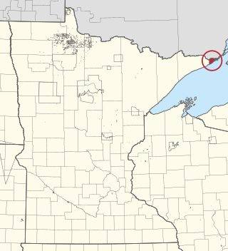
Grand Portage is an unincorporated community in Cook County, Minnesota, United States; located on Grand Portage Bay of the North Shore of Lake Superior.
Colvill is an extinct townsite in Cook County, Minnesota, United States.

Church of St. Francis Xavier is a historic church on Minnesota Highway 61 in Grand Marais, Minnesota, United States. The church began as a Jesuit mission from Fort William, Ontario, in 1855 to minister to the Ojibwe residents of the area. The permanent structure was built in 1895 and was used until declining attendance forced it to close in 1936. The Cook County Historical society restored the site between 1970 and 1974 and it was added to the National Register in 1986. The church is located in the abandoned townsite of Chippewa City.


