
George Armstrong Custer was a United States Army officer and cavalry commander in the American Civil War and the American Indian Wars.

Holbrook is a city in Navajo County, Arizona, United States. According to the 2010 census, the population of the city was 5,053. The city is the county seat of Navajo County.

Limerick is a town in York County, Maine, United States. It is part of the Portland–South Portland–Biddeford, Maine metropolitan statistical area. The population was 3,188 at the 2020 census.

Lake Pleasant is a town in Hamilton County, New York, United States. The population was 897 at the 2020 census. It contains the hamlet of Lake Pleasant, the county seat of Hamilton County.

Weatherford is a city and the county seat of Parker County, Texas, United States. In 2020, its population was 30,854. Weatherford is named after Thomas J. Weatherford, a State senator and advocate for Texas's secession to the Confederate States.

Guthrie is an unincorporated community and census-designated place (CDP) in, and the county seat of, King County in the U.S. state of Texas. It is in the northern part of the state, 93 miles (150 km) east of Lubbock. It serves as the principal headquarters of the Four Sixes Ranch. As of the 2010 census, its population was 160.

Mount Bonnell, also known as Covert Park, is a prominent point alongside the Lake Austin portion of the Colorado River in Austin, Texas. It has been a popular tourist destination since the 1850s. The mount provides a vista for viewing the city of Austin, Lake Austin, and the surrounding hills. It was designated a Recorded Texas Historic Landmark in 1969, bearing Marker number 6473, and was listed on the National Register of Historic Places in 2015.

The Battle of Bear Paw was the final engagement of the Nez Perce War of 1877. Following a 1,200-mile (1,900 km) running fight from north central Idaho Territory over the previous four months, the U.S. Army managed to corner most of the Nez Perce led by Chief Joseph in early October 1877 in northern Montana Territory, just 42 miles (68 km) south of the border with Canada, where the Nez Perce intended to seek refuge from persecution by the U.S. government.
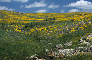
Wichita Mountains Wildlife Refuge, located in southwestern Oklahoma near Lawton, has protected unique wildlife habitats since 1901 and is the oldest managed wildlife facility in the United States Fish and Wildlife Service system. The refuge's location in the geologically unique Wichita Mountains and its areas of undisturbed mixed grass prairie make it an important conservation area. The Wichita Mountains are approximately 500 million years old. Measuring about 59,020 acres (238.8 km2), the refuge hosts a great diversity of species: 806 plant species, 240 species of birds, 36 fish, and 64 reptiles and amphibians are present.

Moraine State Park is a Pennsylvania state park on 16,725 acres (6,768 ha) in Brady, Clay, Franklin, Muddy Creek, and Worth townships in Butler County, Pennsylvania.

Pleasant Tackitt was a 19th-century politician, pioneer Methodist minister, stockman, teacher, farmer, Indian fighter, and Confederate officer. Tackitt was a key figure in the history of Arkansas and North Texas, including a state representative in the Arkansas General Assembly. Because of his battles with Indians in Texas, Tackitt became known as "the Fighting Parson".
Mann Darius Tackitt (Tackett) and his brother Pleasant Tackitt moved to Parker County, Texas, in 1854, and for a few years lived about 12 miles north of Weatherford, Texas. During 1858, they moved to Jack County, Texas, and settled on Boone's Creek, in the southwestern part of the county.
Antonio de Espejo (1540–1585) was a Spanish explorer who led an expedition, accompanied by Diego Perez de Luxan, into New Mexico and Arizona in 1582–83. The expedition created interest in establishing a Spanish colony among the Pueblo Indians of the Rio Grande valley.

Shanda Renée Sharer was an American girl who was tortured and burned to death in Madison, Indiana, by four teenage girls. She was 12 years old at the time of her death. The crime attracted international attention due to both its brutality and the young age of the perpetrators, who were aged between 15 and 17 years old. The case was covered on national news and talk shows and has inspired a number of episodes on fictional crime shows.
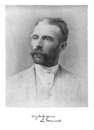
Hu Maxwell was a local historian, novelist, editor, poet, and author of several histories of West Virginia counties.

The Gallinas massacre or the Gallinas Mountains massacre was an engagement of the Apache Wars on September 2, 1861, between a war party of Mescalero Apache warriors and four Confederate soldiers in the Gallinas Mountains of what is now Lincoln County, New Mexico. The incident occurred early in the American Civil War, at a time when the area was claimed by the Confederate States of America as part of Confederate Arizona and military control of the territory had not yet been decisively established by either Union or Confederate forces.
The Querecho Indians were an historical band of Apache people living on the Southern Plains.
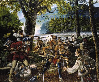
The Battle of the Trough was a skirmish of the early French and Indian War (1754–63) fought between Native Americans and Anglo-American settlers in the valley of the South Branch Potomac River in what is now northern Hardy County, West Virginia, USA.

Union District, formerly Union Magisterial District, is one of five historic magisterial districts in Jackson County, West Virginia, United States. The district was originally known as Hushan's Mills Township, one of five civil townships established in 1863, at the height of the Civil War; it was subsequently given the patriotic name of Union Township. In 1872, West Virginia's townships were converted into magisterial districts. When Jackson County was redistricted in the 1990s, the area of Union District was included in the new Western Magisterial District. However, the county's historic magisterial districts continue to exist in the form of tax districts, serving all of their former administrative functions except for the election of county officials.

Cow Bayou is a bayou in Orange County and Japser County in the U.S. state of Texas. It was formed by the Gum Slough and Dognash Gully. The bayou runs through the cities of Buna, Mauriceville Vidor, and Bridge City. There are 3 tributaries of the Cow Bayou, which includes Cole Creek, Terry Gully, and Coon Bayou.

