Related Research Articles
Reeves County is a county located in the U.S. state of Texas. As of the 2010 census, its population was 13,783. Its county seat and most populous city is Pecos. The county was created in 1883 and organized the next year. It is named for George R. Reeves, a Texas state legislator and colonel in the Confederate Army. It is one of the nine counties that comprise the Trans-Pecos region of West Texas. Reeves County comprises the Pecos micropolitan statistical area.

Presidio County is a county located in the U.S. state of Texas. As of the 2010 census, its population was 7,818. Its county seat is Marfa. The county was created in 1850 and later organized in 1875. Presidio County is in the Trans-Pecos region of West Texas and is named for the ancient border settlement of Presidio del Norte. It is on the Rio Grande, which forms the Mexican border.

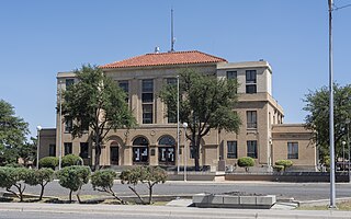
Brewster County is a county located in the western part of the U.S. state of Texas. As of the 2010 census, the population was 9,232. Its county seat and only city is Alpine. The county is named for Colonel Henry Percy Brewster, a Secretary of War for the Republic of Texas.

Sioux County is a county in the U.S. state of Nebraska. As of the 2010 United States Census, the population was 1,311. Its county seat is Harrison.

Harrison is a village in Sioux County, Nebraska, United States. The population was 251 at the 2010 census. It is the county seat of Sioux County.

Lovington is a city in and the county seat of Lea County, New Mexico, United States. The population was 11,009 at the 2010 census, up from 9,471 at the 2000 census.

Alpine is a city in and the county seat of Brewster County, Texas, United States. The population was 5,905 at the 2010 census. The town has an elevation of 4,475 ft, and the surrounding mountain peaks are over a mile (1600 m) above sea level. The university, hospital, library, and retail make Alpine the center of the sprawling 12,000 square miles (31,000 km2) but wide open Big Bend area including Brewster, Presidio, and Jeff Davis Counties.

Fort Davis is an unincorporated community and census-designated place (CDP) in Jeff Davis County, Texas, United States. The population was 1,201 at the 2010 census, up from 1,050 at the 2000 census. It is the county seat of Jeff Davis County. It was the site of Fort Davis, established in 1854 on the San Antonio–El Paso Road through west Texas and named after Jefferson Davis, who was then the Secretary of War under President Franklin Pierce.
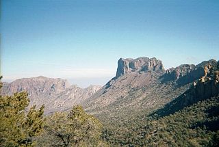
The Big Bend is part of the Trans-Pecos region in southwestern Texas, United States along the border with Mexico, north of the prominent bend in the Rio Grande for which the region is named. Here the Rio Grande passes between the Chisos Mountains in Texas and the Sierra Madre Oriental in Mexico as it changes from running east-southeast to north-northeast. The region covers three counties: Presidio County to the west, Brewster County to the east, and Jeff Davis County to the north.
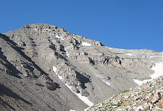
Castle Peak is the ninth highest summit of the Rocky Mountains of North America and the U.S. state of Colorado. The prominent 14,279-foot (4352.2 m) fourteener is the highest summit of the Elk Mountains and the Maroon Bells-Snowmass Wilderness. The peak is located 11.6 miles (18.7 km) northeast by north of the Town of Crested Butte, Colorado, United States, on the drainage divide separating Gunnison National Forest and Gunnison County from White River National Forest and Pitkin County. The summit of Castle Peak is the highest point of both counties.

Upper Kirby is a commercial district in Houston, Texas, United States. It is named after Kirby Drive, so indirectly takes its name from John Henry Kirby.

Agate is an unincorporated community and U.S. Post Office in Elbert County, Colorado, United States. The ZIP Code of the Agate Post Office is 80101.

Needle Peak is located in Presidio County, in southwest Texas, United States. Its summit, at an elevation of 4,608 feet (1,405 m) above sea level, rises 328 ft (100 m) over the Lower Shutup, a canyon that runs along its eastern edge. Needle Peak is a Tertiary intrusion and stands within the Solitario, a circular domal uplift with a nine-mile diameter and a prominent limestone rim. The area is desert mountain terrain of basalt deposits. The vegetation consists primarily of sparse grasses, cacti, desert shrubs, and scrub brush. Needle Peak was named for its configuration.
Agate is an unincorporated community in southeastern Rolette and western Towner counties in the U.S. state of North Dakota. It lies along North Dakota Highway 66, south and northwest respectively of the cities of Rolla and Cando, the county seats of Rolette and Towner counties respectively. Its elevation is 1,657 feet (505 m), and it is located at 48°37′22″N99°29′36″W. Although it is unincorporated, Agate has the ZIP code of 58310.
Needle Peak may refer to:

Study Butte is a census-designated place (CDP) in Brewster County, Texas, United States. The population was 233 at the 2010 census. At the 2000 census, the area was part of the Study Butte-Terlingua CDP.

Buchel County was a former Texas county. Its area is now completely contained in the present Brewster County.
Foley County is a defunct county in the U.S. state of Texas. It was located in the Big Bend area of far West Texas in what is now Brewster County.

Castolon, also known as La Harmonia Ranch and Campo Santa Helena, was a small community in southwestern Texas, located in what is now Big Bend National Park along the Rio Grande. The location was first settled in 1901 by Cipriano Hernandez, who farmed the area and built the original Castolon Store, now known as the Alvino House.
References
- ↑ Tommy R. Woodward. "Needle Peak Geology". Archived from the original on 2016-03-03. Retrieved 2008-04-08.
- ↑ "Agates with Inclusions". Archived from the original on 2008-05-16. Retrieved 2008-04-08.
Coordinates: 29°25′42″N103°48′37″W / 29.4282178°N 103.8102453°W
 | This article about a location in Brewster County, Texas is a stub. You can help Wikipedia by expanding it. |