
Boyd County is a county in the State of Nebraska. As of the 2010 United States Census, the population was 2,099. Its county seat is Butte. The county was formed in 1891 and named after James E. Boyd, the Nebraska Governor at the time.
Bare literally means fully or partially naked, or figuratively used it means minimal.
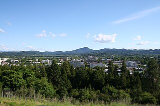
Spencer Butte is a prominent landmark in Lane County, Oregon, United States, described in the National Geodetic Survey as "a prominent timbered butte with a bare rocky summit" on the southern edge of Eugene, with an elevation of 2,058 feet (627 m). Spencer Butte is accessible from Spencer Butte Park and has several hiking trails to the summit. The tree cover on the butte is predominantly Douglas fir, however the butte is treeless at its summit. The butte is the tallest point visible when looking south from downtown Eugene.
Greenwood Mountain is the name of several mountain summits in the United States.

The Kettle River Range, often called the Kettle Range, is the southernmost range of the Monashee Mountains, located in far southeastern British Columbia, Canada and Ferry County, Washington, in the United States. Most of the northern half of the range is protected by the Colville National Forest and the southern half of the range is located on the Colville Indian Reservation. The highest peak is Copper Butte, which reaches 2,177 metres (7,142 ft). The range is crossed by Washington State Route 20 at Sherman Pass.

Study Butte is a census-designated place (CDP) in Brewster County, Texas, United States. The population was 233 at the 2010 census. At the 2000 census, the area was part of the Study Butte-Terlingua CDP.

The Fra Cristobal Range, is a 17 mi (27 km) long, mountain range in central-north Sierra County, New Mexico. The range borders the eastern shore of Elephant Butte Reservoir on the Rio Grande, and the range lies towards the southwest of the Jornada del Muerto, the desert region east of the river.

Missouri Buttes are located in Crook County in northeast Wyoming on the northwest flank of the Black Hills Uplift. The buttes are 3.5 miles (5.6 km) northwest (N60°W) of Devils Tower between the Little Missouri and the Belle Fourche rivers.
Pima Butte is a mountain summit in Pinal County, Arizona eight miles north of present-day Maricopa, Arizona. Pima Butte is 1,660 feet above sea level. As a significant landmark in the Gila Valley it was near the site of the 1857 Battle of Pima Butte, to which it gave its name.
Tongue Butte is a summit in Sheridan County, Wyoming, in the United States. With an elevation of 7,946 feet (2,422 m), Tongue Butte is the 885th tallest mountain in Wyoming.
Bachelor Peak is a summit in Burnet County, Texas, in the United States.
Rainy Butte is a summit in Slope County, North Dakota, in the United States. With an elevation of 2,913 feet (888 m), Rainy Butte is the 33rd highest summit in the state of North Dakota.
Grindstone Butte is a summit in Haakon County, South Dakota, in the United States. With an elevation of 2,595 feet (791 m), Grindstone Butte is the 417th highest summit in the state of South Dakota.
Turtle Butte is a summit in Tripp County, South Dakota, in the United States. With an elevation of 2,343 feet (714 m), Turtle Butte is the 456th highest summit in the state of South Dakota.
Hump Butte is a summit in South Dakota, in the United States. With an elevation of 2,431 feet (741 m), Hump Butte is the 453rd highest summit in the state of South Dakota.
Elephant Butte is a summit now located in the Elephant Butte Reservoir and within the Elephant Butte Lake State Park in Sierra County, New Mexico. It has an elevation of 4,639 feet (1,414 m). It was named for its shape, said to look like an elephant.
Elephant Butte is a summit in Hidalgo County, New Mexico. It lies at an elevation of 6,361 feet / 1,939 meters, on the Cowboy Rim of the Animas Mountains.
Bitsihuitsos Butte is a summit in the U.S. state of Arizona.


