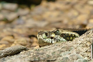
The Crotalinae, commonly known as pit vipers, crotaline snakes, or pit adders, are a subfamily of vipers found in Eurasia and the Americas. Like all other vipers, they are venomous. They are distinguished by the presence of a heat-sensing pit organ located between the eye and the nostril on both sides of the head. Currently, 23 genera and 155 species are recognized: These are also the only viperids found in the Americas. The groups of snakes represented here include rattlesnakes, lanceheads, and Asian pit vipers. The type genus for this subfamily is Crotalus, of which the type species is the timber rattlesnake, C. horridus.
Garfield Peak is a prominent mountain in the U.S. state of Wyoming. It is the highest point in the Rattlesnake Hills.
Rattlesnake Ridge, known as daʔšədabš to the Snoqualmie people, is the ridge of Rattlesnake Mountain located south of North Bend, Washington, United States. The western end is near the intersection of State Route 18 and I-90 in Snoqualmie, Washington, and runs southeast about 7 miles (11 km) or 11 miles (18 km) by trail. It is the highest and easternmost of the Issaquah Alps. A maze of abandoned logging roads and constructed trails have been strung together to provide a 10.5-mile (16.9 km) footpath from the Snoqualmie Point trailhead at Exit 27 on I-90 all the way to the Rattlesnake Lake trailhead near Exit 32.

The Virgin Mountains are a mountain range of the northeastern Mojave Desert, located in Clark County, southeastern Nevada and Mohave County, northwestern Arizona.

The Bigelow Cholla Garden Wilderness is in the eastern Mojave Desert and within Mojave Trails National Monument, located in San Bernardino County, California.

Blue Hills Reservation is a 7,000-acre (2,800 ha) state park in Norfolk County, Massachusetts in the United States. Managed by the Massachusetts Department of Conservation and Recreation, it covers parts of Milton, Quincy, Braintree, Canton, Randolph, and Dedham. Located approximately ten miles south of downtown Boston, the reservation is one of the largest parcels of undeveloped conservation land within the Greater Boston metropolitan area. The park's varied terrain and scenic views make it a popular destination for hikers from the Boston area.

Crotalus helleri, known as the Southern Pacific rattlesnake, black diamond rattlesnake, and by other names, is a pit viper subspecies found in southwestern California and south into Baja California, Mexico, that is known for its regional variety of dangerous venom types.

Pinnacle Peak is a granite summit located in Scottsdale, Arizona. The peak rises to an elevation of 3,169 feet (966 m). It is located within the 150-acre (61 ha) Pinnacle Peak Park, operated by the City of Scottsdale Park District. Part of the Sonoran Desert, the park is home to a variety of native desert flora and fauna. Hikers utilize a 1.75 mile trail to explore the area, though rock climbing skills are needed to reach the summit.
Cascabel is a ghost town in Cochise County, Arizona, United States.

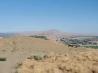
Rattlesnake Mountain is a 3,531 ft windswept treeless ridge overlooking the Hanford nuclear site. Parts of the western slope are privately owned ranchland, while the eastern slope is under the federal protection of the Arid Lands Ecology Reserve, a unit of the Hanford Reach National Monument, managed by the United States Fish and Wildlife Service. The mountain is the second highest point in Benton County, with its neighbor Lookout Summit surpassing it by only 98 ft.
The Rattlesnake Hills, also known as Rattlesnake Ridge, is a 16-mile (26 km) long anticline mountain ridge in Yakima County and Benton County in the U.S. state of Washington. It should not be confused with the much smaller Rattlesnake Ridge located near the west end of Ahtanum Ridge just south of Yakima, Washington and west of Union Gap, Washington. The highest point in the hills is the 3,629 feet (1,106 m) Lookout Summit, which surpasses the more well-known Rattlesnake Mountain by approximately 100 ft. The Rattlesnake Hills are part of the Yakima Fold Belt of east-tending long ridges formed by the folding of Miocene Columbia River basalt flows.
The Whipple Mountains Wilderness is a 76,122-acre (30,805 ha) wilderness administered by the Bureau of Land Management (BLM). Most of the Whipple Mountains are within the wilderness area. It is located in the northeastern Colorado Desert near the Colorado River. Lake Havasu and Lake Havasu City are 25 miles (40 km) to the North. Earp, California and Parker, Arizona are 20 miles (32 km) to the South. The Parker Dam is 8 miles (13 km) due east.
Weatherby is an unincorporated community in Baker County, Oregon, United States. It is about 9 miles (14 km) southeast of Durkee on Interstate 84/U.S. Route 30, near the Burnt River.
Temescal Mountains, also known as the Sierra Temescal, are one of the northernmost mountain ranges of the Peninsular Ranges in western Riverside County, in Southern California in the United States. They extend for approximately 25 mi (40 km) southeast of the Santa Ana River east of the Elsinore Fault Zone to the Temecula Basin and form the western edge of the Perris Block.
Rattlesnake Mountain is a peak of the Kittatinny Mountains in Sussex County, New Jersey, United States. The mountain stands 1,489 feet (454 m) high. It lies along the Appalachian Trail in the Delaware Water Gap National Recreation Area. Located near the junction of Mullins Rd. (unmarked) and the trail. Rattlesnakes like any of the rocky areas of the Kittatinny Ridge, for sunning themselves.
Rattlesnake Creek is a tributary of Spring Brook in Lackawanna County, Pennsylvania, in the United States. It is approximately 5.0 miles (8.0 km) long and flows through Spring Brook Township. The watershed of the creek has an area of 9.18 square miles (23.8 km2). The creek has one named tributary, which is known as Six Springs Creek. Rattlesnake Creek is inhabited by wild trout and part of it is considered to be Class A Wild Trout Waters. A dammed lake known as Maple Lake is located near its headwaters. The surficial geology in the area mainly consists of Wisconsinan Till and bedrock, with some alluvium, Wisconsinan Ice-Contact Stratified Drift, wetlands, and peat bogs.
Cuba is an unincorporated community in the northwestern part of Montgomery Township, Owen County, in the U.S. state of Indiana. It lies near the intersection of County Road 150 West and County Road 600 North, which is a community about ten miles north of the town of Spencer, the county seat of Owen County. Its elevation is 722 feet, and it is located at 39°22′41″N86°47′53″W.
Candy Mountain is a small mountain located just outside West Richland, Washington. Candy Mountain rises above the Tri-Cities, located between Badger Mountain to the south and Red Mountain to the north.

Lookout Summit—officially listed as "Lookout" in the Geographic Names Information System—is the highest point in Benton County, in the U.S. state of Washington. The mountain is also the highest point in the Rattlesnake Hills, with an elevation 98 ft higher than the neighboring, more-well-known Rattlesnake Mountain—which is the second highest peak in the range.
