
Castle Rock is an affluent home rule municipality that is the county seat of Douglas County, Colorado, United States. The most populous municipality of the county, the community's population was 48,231 at the 2010 United States Census, with an estimated population of 55,747 as of 2014. It is named for the prominent, castle tower-shaped butte near the center of town. Located midway between Denver and Colorado Springs, Castle Rock is part of the Denver metropolitan area and the Front Range Urban Corridor.

Pampa is a city in Gray County, Texas, United States. The population was 17,994 as of the 2010 census. Pampa is the county seat of Gray County and is the principal city of the Pampa Micropolitan Statistical Area, which includes both Gray and Roberts counties.

George Harvey Strait Sr. is an American country music singer, songwriter, actor, and music producer. George Strait is known as the "King of Country" and is considered one of the most influential and popular recording artists of all time. He is known for his neotraditionalist country style, cowboy look, and being one of the first and main country artists to bring country music back to its roots and away from the pop country era in the 1980s.

The Blarney Stone is a block of Carboniferous limestone built into the battlements of Blarney Castle, Blarney, about 8 kilometres from Cork, Ireland. According to legend, kissing the stone endows the kisser with the gift of the gab. The stone was set into a tower of the castle in 1446. The castle is a popular tourist site in Ireland, attracting visitors from all over the world to kiss the stone and tour the castle and its gardens.

Hurricane Carla ranks as the most intense U.S. tropical cyclone landfall on the Hurricane Severity Index. The third named storm and first Category 5 hurricane of the 1961 Atlantic hurricane season, Carla developed from an area of squally weather in the southwestern Caribbean Sea on September 3. Initially a tropical depression, it strengthened slowly while heading northwestward, and by September 5, the system was upgraded to Tropical Storm Carla. About 24 hours later, Carla was upgraded to a hurricane. Shortly thereafter, the storm curved northward while approaching the Yucatán Channel. Late on September 7, Carla entered the Gulf of Mexico while passing just northeast of the Yucatán Peninsula. By early on the following day, the storm became a major hurricane after reaching Category 3 intensity. Resuming its northwestward course, Carla continued intensification and on September 11, it was upgraded to a Category 5 hurricane. Later that day, Carla weakened slightly, but was still a large and intense hurricane when the storm made landfall near Port O'Connor, Texas. It weakened quickly inland and was reduced to a tropical storm on September 12. Heading generally northward, Carla transitioned into an extratropical cyclone on September 13, while centered over southern Oklahoma. Rapidly moving northeastward, Carla's remnants reached the Labrador Sea, Canada and dissipated on September 17, 1961.
Castle Peak is the ninth highest summit of the Rocky Mountains of North America and the U.S. state of Colorado. The prominent 14,279-foot (4352.2 m) fourteener is the highest summit of the Elk Mountains and the Maroon Bells-Snowmass Wilderness. The peak is located 11.6 miles (18.7 km) northeast by north of the Town of Crested Butte, Colorado, United States, on the drainage divide separating Gunnison National Forest and Gunnison County from White River National Forest and Pitkin County. The summit of Castle Peak is the highest point of both counties.

Big Spring State Park is a Texas state park in Big Spring, Howard County, Texas in the United States. It was opened in 1936 after the 381.99 acres (154.59 ha) upon which it is situated was deeded to the state by the city of Big Spring in 1934 and 1935. It is named for the natural spring once located on the site that was later replaced by an artificial one.

Needle Peak is located in Presidio County, in southwest Texas, United States. Its summit, at an elevation of 4,608 feet (1,405 m) above sea level, rises 328 ft (100 m) over the Lower Shutup, a canyon that runs along its eastern edge. Needle Peak is a Tertiary intrusion and stands within the Solitario, a circular domal uplift with a nine-mile diameter and a prominent limestone rim. The area is desert mountain terrain of basalt deposits. The vegetation consists primarily of sparse grasses, cacti, desert shrubs, and scrub brush. Needle Peak was named for its configuration.

Castle is an American crime-comedy-drama television series, which aired on ABC for a total of eight seasons from March 9, 2009, to May 16, 2016. The series was produced jointly by Beacon Pictures and ABC Studios.
Carpenter Mountain is a mountain peak in Jeff Davis County, Texas. Its summit is 5,826 feet (1,776 m) above sea level. Carpenter Mountain is about 12 mi (19 km) west-southwest of Fort Davis, Texas.

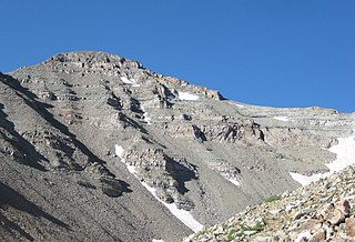
Castle Peak is a mountain in the western United States, the highest peak in the White Cloud Mountains of central Idaho. Located in Custer County, it is the 25th highest peak in the state, and the ninth most prominent.

The Smoky Mountains are part of the Rocky Mountains and located on the west side of the Wood River Valley near Sun Valley, Idaho, in the Western United States. The range is within Sawtooth National Forest, while part of it is within the Sawtooth National Recreation Area. The highest point in the range is Saviers Peak at 10,441 ft (3,182 m).

D. O. Lee Peak, also known as Lee Peak, at 11,347 feet (3,459 m) above sea level, is the third-highest peak in the White Cloud Mountains of the U.S. state of Idaho. It is one of the White Cloud Peaks and the 56th-highest peak in Idaho. It was named after Challis native David Oliver Lee (1934–1982), the first United States Forest Service ranger to be assigned to the Sawtooth Wilderness.

Fourth of July Peak at 10,713 feet (3,265 m) above sea level is a peak in the White Cloud Mountains of Idaho. The peak is located in Sawtooth National Recreation Area in Custer County 2.54 mi (4.09 km) from Castle Peak, its line parent. It is the 201st highest peak in Idaho and rises to the west of Fourth of July and Washington lakes.

Patterson Peak at 10,872 feet (3,314 m) above sea level is a peak in the White Cloud Mountains of Idaho. The peak is located in Sawtooth National Recreation Area in Custer County 2.70 mi (4.35 km) west of Castle Peak, its line parent. Patterson Peak is about 1.5 mi (2.4 km) northeast of Fourth of July Peak, and it rises to the east of Fourth of July Lake. Glacier, Rock, Emerald, and Cornice lakes are in the basin to the northeast of the peak.

Blackmon Peak, also known as Blackman Peak, at 10,302 feet (3,140 m) above sea level is a peak in the White Cloud Mountains of Idaho. The peak is located in Sawtooth National Recreation Area in Custer County 2.11 mi (3.40 km) from Castle Peak, its line parent. It is named for George Blackmon (b.1854), freed slave and mining pioneer.

Castle Peak is a prominent mountain summit in the northern Sawatch Range of the Rocky Mountains of North America. The 11,305-foot (3,446 m) peak is located 9.6 miles (15.5 km) north of the Town of Eagle in Eagle County, Colorado, United States.
Ronald Eugene "Trey" Ball III is an American professional baseball pitcher in the Boston Red Sox organization.

Calkins Peak, is a peak also known as Calkens, O'Calkens Peak, Caulkens Peak, and O'Caulkens Peak. At an elevation of 11,487 feet (3,501 m) above sea level it is the second highest peak in the White Cloud Mountains of Idaho. The peak is located in Sawtooth National Recreation Area in Custer County about 5.75 mi (9.25 km) north-northwest of Castle Peak, its line parent. It is the 46th highest peak in Idaho, and it is located about 0.5 mi (0.80 km) north-northeast of White Cloud Peak 9 and 1 mi (1.6 km) north-northwest of D. O. Lee Peak. Calkins Peak is directly north of Slide Lake, northwest of Sheep Lake, and southwest of Tin Cup Lake. Calkins Peak is named for Stephen Calkins (1842–1922), a prospector who established lode claims in the area.


