Packsaddle Mountain (Llano County, Texas)

Last updated
Packsaddle Mountain
Packsaddle mountain.jpg
Packsaddle Mountain Cliff Face
Highest point
Elevation 1,628 ft (496 m)
Prominence 548 ft (167 m) [1]
Parent peak Enchanted Rock
Coordinates 30°37′14″N98°30′29″W / 30.62056°N 98.50806°W / 30.62056; -98.50806 [2]
Geography
Relief map of Texas.png
Red triangle with thick white border.svg
Packsaddle Mountain
Parent range Llano Uplift
Topo map USGS Cap Mountain

Named after the saddle-like appearance provided by twin peaks, Packsaddle Mountain is a landmark hill that stands five miles southwest of Kingsland, Texas in eastern Llano County on State Highway 71 and is of interest to both historians and geologists. In 1873 it was the site of the Packsaddle Mountain Fight, the last major Native American battle in the area. The mountain is now part of a large ranch called Packsaddle Ranch.

Contents

History

It is thought that the Spanish mined the mountain for gold prior to the Texas Revolution and that it was the site of Los Almagres, Jim Bowie’s famous lost mine. [3] Prospecting on Packsaddle Mountain renewed interest in gold mining in Llano County in the 1920s, but with no lasting result.

The mountain was the site of the Packsaddle Mountain Fight with 21 Apache Tribesmen on August 4, 1873 and was the last major Indian battle in the area. The fight on Packsaddle Mountain was precipitated when a woman from the Moss Ranch (in what is now Llano County) came into the ranch house with an arrow sticking out of her side. A party of eight ranchers, including W.B. Moss and his two brothers, was raised to pursue the raiders. They found some twenty-one Apaches encamped on Packsaddle Mountain. In the ensuing fight, at least three tribesmen were killed and three ranchers wounded.

The Texas state historical marker reads "Two and one half miles east on the Packsaddle Mountain, in a battle fought August 4, 1873, Captain J. R. Moss, Stephen B. Moss, William B. Moss, Eli Lloyd, Arch Martin, Pink Ayers, E. D. Harrington, and Robert Brown routed a band of Indians thrice their number. The last Apache battle in this region." [4] The Apache tribes had been encroaching Tonkawa tribal areas for some time.
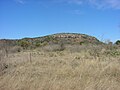
Geography

At an elevation of 1,628 feet, the higher of the two summits rises 650 feet above Highway 71. Local topography ranges from flat to rolling to steep, with local escarpments, covered with soils ranging from shallow and stony to deep, fine, sandy loam. Vegetation consists primarily of open stands of live oak and Ashe juniper. [3]

Pictures

Related Research Articles

<span class="mw-page-title-main">Presidio County, Texas</span> County in Texas, United States

Presidio County is a county located in the U.S. state of Texas. As of the 2020 census, its population was 6,131. Its county seat is Marfa. The county was created in 1850 and later organized in 1875. Presidio County is in the Trans-Pecos region of West Texas and is named for the border settlement of Presidio del Norte. It is on the Rio Grande, which forms the Mexican border.

<span class="mw-page-title-main">Llano County, Texas</span> County in Texas, United States

Llano County is a county located on the Edwards Plateau in the U.S. state of Texas. As of the 2020 census, its population was 21,243. Its county seat is Llano, and the county is named for the Llano River.

<span class="mw-page-title-main">Kimble County, Texas</span> County in Texas, United States

Kimble County is a county located on the Edwards Plateau in the U.S. state of Texas. As of the 2020 census, its population was 4,286. Its county seat is Junction. The county was created in 1858 and organized in 1876. It is named for George C. Kimble, who died at the Battle of the Alamo.

<span class="mw-page-title-main">Brewster County, Texas</span> County in Texas, United States

Brewster County is a county located in the U.S. state of Texas. It is in West Texas and its county seat is Alpine. It is one of the nine counties that comprise the Trans-Pecos region, and borders Mexico. Brewster County is the largest county by area in the state - at 6,192 square miles (16,040 km2) it is over three times the size of the state of Delaware, and more than 500 square miles (1,300 km2) bigger than Connecticut.

<span class="mw-page-title-main">Dewey–Humboldt, Arizona</span> Town in Yavapai County, Arizona

Dewey–Humboldt is a town in Yavapai County, Arizona, United States. The population of the town was 3,894 according to the 2010 census. The Dewey–Humboldt area was a census-designated place (CDP) at the 2000 census, at which time its population was 6,295.

<span class="mw-page-title-main">Big Spring, Texas</span> City in Texas, United States

Big Spring is a city in and the county seat of Howard County, Texas, United States, at the crossroads of U.S. Highway 87 and Interstate 20. With a population of 27,282 as of the 2010 census, it is the largest city between Midland to the west, Abilene to the east, Lubbock to the north, and San Angelo to the south. Big Spring was established as the county seat of Howard County in 1882; it is the largest community in the county.

<span class="mw-page-title-main">Kingsland, Texas</span> Census-designated place in Texas, United States

Kingsland is a census-designated place (CDP) in Llano County, Texas, United States. The population was 6,030 at the 2010 census, up from 4,584 at the 2000 census. Texas Ranch to Market Road 1431 runs through the community.

<span class="mw-page-title-main">Llano, Texas</span> City in Texas, United States

Llano is a city in Llano County, Texas, United States. As of 2010, the city population was 3,232. It is the county seat of Llano County. Llano has been described as the "deer capital of Texas", with the single highest density of white-tailed deer in the United States.

<span class="mw-page-title-main">Texas Hill Country</span> Region of Texas

The Texas Hill Country is a geographic region of Central and South Texas, forming the southeast part of the Edwards Plateau. Given its location, climate, terrain, and vegetation, the Hill Country can be considered the border between the American Southeast and Southwest. The region represents the very remote rural countryside of Central Texas, but also is home to growing suburban neighborhoods and affluent retirement communities.

<span class="mw-page-title-main">Llano Estacado</span> Southwestern United States in New Mexico and Texas

The Llano Estacado, sometimes translated into English as the Staked Plains, is a region in the Southwestern United States that encompasses parts of eastern New Mexico and northwestern Texas. One of the largest mesas or tablelands on the North American continent, the elevation rises from 3,000 feet (900 m) in the southeast to over 5,000 feet (1,500 m) in the northwest, sloping almost uniformly at about 10 feet per mile (2 m/km).

<span class="mw-page-title-main">Enchanted Rock</span> Rock formation and protected area in central Texas

Enchanted Rock is a pink granite mountain located in the Llano Uplift about 17 miles (27 km) north of Fredericksburg, Texas and 24 miles (39 km) south of Llano, Texas, United States. Enchanted Rock State Natural Area, which includes Enchanted Rock and surrounding land, spans the border between Gillespie and Llano counties, south of the Llano River. Enchanted Rock covers roughly 640 acres (260 ha) and rises around 425 feet (130 m) above the surrounding terrain to an elevation of 1,825 feet (556 m) above sea level. It is the largest pink granite monadnock in the United States. Enchanted Rock State Natural Area, a part of the Texas state park system, includes 1,644 acres (665 ha). In 1936, the area was designated a Recorded Texas Historic Landmark. In 1971, Enchanted Rock was designated as a National Natural Landmark by the National Park Service.

<span class="mw-page-title-main">Llano River</span> River in Texas, United States

The Llano River is a tributary of the Colorado River, about 105 miles (169 km) long, in Texas in the United States. It drains part of the Edwards Plateau in Texas Hill Country northwest of Austin.

<span class="mw-page-title-main">Chiricahua Mountains</span> Mountain range in Arizona, United States

The Chiricahua Mountains massif is a large mountain range in southeastern Arizona which is part of the Basin and Range province of the west and southwestern United States and northwest Mexico; the range is part of the Coronado National Forest. The highest point, Chiricahua Peak, rises 9,759 feet (2,975 m) above sea level, approximately 6,000 feet (1,800 m) above the surrounding valleys. The range takes its name from the Chiricahua Apaches native to the region.

<span class="mw-page-title-main">Apache Pass</span> Landform in Cochise County, Arizona

Apache Pass, also known by its earlier Spanish name Puerto del Dado, is a historic mountain pass in the U.S. state of Arizona between the Dos Cabezas Mountains and Chiricahua Mountains at an elevation of 5,110 feet (1,560 m). It is approximately 20 miles (32 km) east-southeast of Willcox, Arizona, in Cochise County.

<span class="mw-page-title-main">Lubbock Lake Landmark</span> Archaeological site in Texas, United States

Lubbock Lake Landmark, also known as Lubbock Lake Site, is an important archeological site and natural history preserve in the city of Lubbock, Texas, United States. The protected state and federal landmark is 336 acres (136 ha). There is evidence of ancient people and extinct animals at Lubbock Lake Landmark. It has evidence of nearly 12,000 years of use by ancient cultures on the Llano Estacado. It is part of the Museum of Texas Tech University.

<span class="mw-page-title-main">Oliver Lee Memorial State Park</span> State park in New Mexico, United States

Oliver Lee Memorial State Park is a state park of New Mexico, United States, whose two tracts preserve a canyon in the Sacramento Mountains and Oliver Lee's historic 19th-century ranch house. The 640-acre (260 ha) park is located in Otero County at an elevation of 4,363 feet (1,330 m). It is situated at the base of Dog Canyon and provides opportunities for camping, hiking, picnicking, wildlife viewing, a nature trail, and guided tours of the ranch house.

<span class="mw-page-title-main">Sierra Bonita Ranch</span> United States historic place in Arizona

The Sierra Bonita Ranch, founded in 1872 by Henry C. Hooker, is one of the oldest cattle ranches in the United States and the ranch buildings have been designated a National Historic Landmark. It was the first permanent American cattle ranch in Arizona. Hooker bought neighboring ranches until his operation became the largest ranch in Arizona, totaling 800 square miles (2,100 km2), or about 30 by 27 miles. It is located in Sulphur Springs Valley about 27 miles (43 km) north of present-day Willcox, Arizona. The modern ranch is much smaller but is still operational and owned by Jesse Hooker Davis, the sixth generation to live and work on the ranch.

<span class="mw-page-title-main">Henry Hooker</span> American rancher in Arizona Territory (1828–1907)

Henry Clay Hooker was a prominent and wealthy rancher during the American Old West who formed the first and what became the largest American ranch in Arizona Territory. After growing up on the east coast, he married and traveled to California, where he established a hardware store in Hangtown. When it burned, he left for Arizona Territory where he partnered with others to supply cattle to the Army and Indian Agencies. When one of the herds stampeded, he found them in a verdant valley. He established the Sierra Bonita Ranch there. It became one of the largest ranches in the Territory and state of Arizona and was held by family members for several generations. He was a personal friend of Wyatt Earp and aided him after the Earp Vendetta Ride.

<span class="mw-page-title-main">Black Mountain (Maricopa County, Arizona)</span> Landform

Black Mountain is located in north-central Maricopa County, Arizona, between the towns of Carefree and Cave Creek.

The Figure 2 Ranch is located in present-day Culberson County, Texas, founded in 1890 by James Monroe Daugherty, a cattle rancher who owned ranches in several states prior to this date. The site was the scene of one of the last battles between the Texas Rangers and the Apache Indians. Daugherty, a former express rider for the Confederate Army in the American Civil War and a founding member of the Texas and Southwestern Cattle Raisers Association lived on the ranch by 1905 and would later serve on the local county commission for Culberson County after its founding in 1911. At the age of 83, Daugherty sold the ranch to ranching, timber, and oil tycoon James Marion West, Sr. in 1933. West never lived on the ranch, but his son James Jr. maintained a home there which he used as one of his many residences. The ranch remained in the West family until 1992. The Figure 2 Ranch Airport is located on the property. At its height, the ranch encompassed some 175,000 acres. The Figure 2 Ranch is now owned by Jeff Bezos, who is building a 10,000 year clock in part of the Sierra Diablo Mountains that lie on the ranch property. Part of the Figure 2 Ranch property serves as a Blue Origin test and launch facility.

References

  1. "Packsaddle Mountain". Peakbagger.com. Retrieved 2013-01-05.
  2. "Packsaddle Mountain". Geographic Names Information System . United States Geological Survey, United States Department of the Interior . Retrieved 2009-08-30.
  3. 1 2 History - Kingsland Chamber of Commerce
  4. Details for Packsaddle Mountain. Texas Historic Sites Atlas. Retrieved May 29, 2016.