| Hunter Peak | |
|---|---|
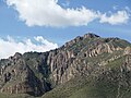
 Southwest aspect | |
| Highest point | |
| Elevation | 8,376 ft (2,553 m) [1] |
| Prominence | 549 ft (167 m) [1] |
| Parent peak | Bush Mountain (8,631 ft) [2] |
| Isolation | 2.37 mi (3.81 km) [2] |
| Coordinates | 31°54′50″N104°49′49″W / 31.9138446°N 104.8303020°W [3] |
| Naming | |
| Etymology | Jessie Coleman Hunter [4] |
| Geography | |
 Hunter Peak Location of Hunter Peak in Texas  Hunter Peak Hunter Peak (the United States) | |
| Country | United States |
| State | Texas |
| County | Culberson |
| Protected area | Guadalupe Mountains National Park [1] |
| Parent range | Guadalupe Mountains [1] |
| Topo map | USGS Guadalupe Peak |
| Geology | |
| Rock age | Lopingian |
| Rock type | Limestone |
| Climbing | |
| Easiest route | class 1 hiking [2] |
Hunter Peak is an 8,376-foot-elevation (2,553-meter) summit in Culberson County, Texas, United States.