Snow Mountain (Franklin County, Maine)

Last updated
Snow Mountain

MontSnow2.jpg

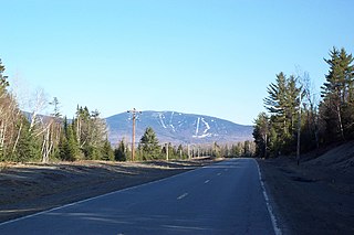
Snow Mountain as seen from Piopolis, Quebec
Highest point
Elevation 3,960 ft (1,210 m)
Prominence 2,329 ft (710 m) [1]
Listing New England Fifty Finest #24
New England 100 Highest #70
Coordinates 45°17′29″N70°42′34″W / 45.2915°N 70.709333°W / 45.2915; -70.709333 Coordinates: 45°17′29″N70°42′34″W / 45.2915°N 70.709333°W / 45.2915; -70.709333 [2]
Geography
USA Maine location map.svg
Red triangle with thick white border.svg
Snow Mountain
Topo map USGS Chain of Ponds
Climbing
Easiest route Hiking trail

Snow Mountain is a mountain located in Franklin County, Maine, about 5 mi (8 km) from the Canada–United States border. [3] Snow Mtn. is flanked to the northeast by Bag Pond Mountain, and to the southeast by Round Mountain.

Mountain A large landform that rises fairly steeply above the surrounding land over a limited area

A mountain is a large landform that rises above the surrounding land in a limited area, usually in the form of a peak. A mountain is generally steeper than a hill. Mountains are formed through tectonic forces or volcanism. These forces can locally raise the surface of the earth. Mountains erode slowly through the action of rivers, weather conditions, and glaciers. A few mountains are isolated summits, but most occur in huge mountain ranges.

Franklin County, Maine county in Maine, United States of America

Franklin County is a county located in the state of Maine, in the United States. As of the 2010 census, the population was 30,768, making it the second-least populous county in Maine. Its county seat is Farmington. The county was established on May 9, 1838 and named for Benjamin Franklin.

Maine State of the United States of America

Maine is a state in the New England region of the northeastern United States. Maine is the 12th smallest by area, the 9th least populous, and the 38th most densely populated of the 50 U.S. states. It is bordered by New Hampshire to the west, the Atlantic Ocean to the southeast, and the Canadian provinces of New Brunswick and Quebec to the northeast and northwest respectively. Maine is the easternmost state in the contiguous United States, and the northernmost state east of the Great Lakes. It is known for its jagged, rocky coastline; low, rolling mountains; heavily forested interior; and picturesque waterways, as well as its seafood cuisine, especially lobster and clams. There is a humid continental climate throughout most of the state, including in coastal areas such as its most populous city of Portland. The capital is Augusta.

The north side of Snow Mountain drains into Indian Stream, then into Chain of Ponds, the North Branch of the Dead River, Flagstaff Lake, the Dead River, the Kennebec River, and into the Gulf of Maine. The southeast side of Snow Mountain drains into Little Alder Stream, then into Alder Stream, and the North Branch of the Dead River. The north side of Snow Mountain drains into Big Island Pond, then into the Kennebago River, and the Androscoggin River, which drains into Merrymeeting Bay, the estuary of the Kennebec River.

The North Branch Dead River is a 19.3-mile-long (31.1 km) tributary of the Dead River in Franklin County, Maine. It is paralleled by Maine State Route 27.

Flagstaff Lake (Maine) lake

Flagstaff Lake is located in Somerset County and Franklin County, Maine in the United States. The North Branch Dead River and South Branch Dead River join in the lake, forming the Dead River.

Kennebec River river in Maine, United States

The Kennebec River is a 170-mile-long (270 km) river within the U.S. state of Maine.

See also

There are various mountains called Snow Mountain in the United States:

Related Research Articles

Mount Kelsey is a mountain located in the western portion of Millsfield, New Hampshire. The western slopes of the mountain are contained within the township of Erving's Location, New Hampshire. The summit is occupied by part of the Granite Reliable Wind Farm, with road access from the Phillips Brook watershed to the south.

Moxie Falls

Moxie Falls is a waterfall in Somerset County, Maine. At a vertical drop of over 90 feet (30 m) into a pool about 17 feet (5 m) deep, Moxie Falls is one of the highest falls in New England. The falls are part of Moxie Stream which flows from Moxie Pond into the Kennebec River approximately 1 kilometer (0.62 mi) downstream the falls. Moxie Stream drains Moxie Pond approximately 5 miles (8.0 km) upstream of the falls.

Crocker Mountain (Maine) mountain in United States of America

Crocker Mountain is a 4,228 ft (1,289 m) peak located in Carrabassett Valley, Franklin County, Maine, in the United States. Crocker Mountain is the fourth highest mountain in the state after the Katahdins and Sugarloaf Mountain, and is part of the Appalachian Mountains. Crocker Mountain is traversed by the Appalachian Trail (AT), a 2,170 mi (3,490 km) National Scenic Trail from Georgia to Maine.

Saddleback Mountain (Rangeley, Maine)

Saddleback Mountain is a mountain located in Sandy River Plantation, Franklin County, Maine, near the resort town of Rangeley. Saddleback is one of the highest mountains in the State of Maine, and one of the fourteen with more than 2,000 ft (610 m) of topographic prominence. The mountain is the site of Saddleback ski resort.

Sandy Bay Mountain

Sandy Bay Mountain, known officially in Quebec as Mont Sandy Stream, is a mountain located on the Canada–United States border, with a height of 950 m (3,117 ft) above sea level. The northeastern part of the mountain is in Somerset County, Maine, while the southwestern part is in Saint-Ludger, Quebec. There, it is unofficially known as Mont Bélanger.

Old Speck Mountain mountain in United States of America

Old Speck Mountain, also known as Old Speckle Mountain, is a mountain located in Oxford County, Maine, United States. The mountain, the fourth-highest in the state, is the northeasternmost and highest of the Mahoosuc Range, the northeasternmost part of the White Mountains. Old Speck is flanked to the southwest by Mahoosuc Arm, and faces Baldpate Mountain to the northeast across Grafton Notch.

Spaulding Mountain mountain in United States of America

Spaulding Mountain is a mountain located in Franklin County, Maine. Spaulding Mountain is flanked to the northeast by Sugarloaf Mountain, and to the southeast by Mount Abraham.

South Crocker Mountain mountain in United States of America

South Crocker Mountain is a mountain located in Franklin County, Maine. South Crocker Mountain is flanked to the north by Crocker Mountain, and to the southwest by Mount Redington.

Coburn Mountain (Maine) mountain in United States of America

Coburn Mountain is a mountain located in Somerset County, Maine.

Kibby Mountain mountain in United States of America

Kibby Mountain is a mountain located in Franklin County, Maine, about 3.5 mi (5.6 km) east of the Canada–United States border. Kibby Mountain is flanked to the southeast by Spencer Bale Mountain.

Baldpate Mountain (Maine)

Baldpate Mountain is a mountain located in Oxford County, Maine. Baldpate has two prominent peaks; West Peak has 3,662 feet (1,116 m) of elevation, and stands 222 feet (68 m) above the col between them.

Baker Mountain (Piscataquis County, Maine)

Baker Mountain is a wild, trail-less mountain located in Beaver Cove, Piscataquis County, Maine. It is flanked to the northwest by Lily Bay Mountain. Elephant Mountain is about 2 miles (3 km) to the southwest, and White Cap Mountain is about 5 miles (8 km) to the east.

Big Moose Mountain mountain in United States of America

Big Moose Mountain, previously named Big Squaw Mountain, is a mountain located in Piscataquis County, Maine. Big Moose Mountain is flanked to the southeast by Little Moose Mountain.

Boundary Bald Mountain mountain in United States of America

Boundary Bald Mountain is a mountain located in Somerset County, Maine, about 7.5 mi (12.1 km) southeast of the Canada–US border with Quebec. Boundary Bald Mountain is flanked to the east by Ironbound Mountain, and to the west by Sandy Bay Mountain.

Big Spencer Mountain mountain in United States of America

Big Spencer Mountain is a mountain located in Piscataquis County, Maine. Big Spencer Mtn. is flanked to the west by Little Spencer Mountain.

Moxie Mountain mountain in United States of America

Moxie Mountain is a mountain located in Somerset County, Maine.

East Kennebago Mountain mountain in United States of America

East Kennebago Mountain is a trailless mountain located in Franklin County, Maine. East Kennebago Mtn. is a monadnock, flanked by its spurs: Tim Mountain to the north, Black Spur to the west, and Blackcat Mountain to the southwest.

Snow Mountain (Oxford County, Maine)

Snow Mountain is a mountain located in Oxford County, Maine, about 4 mi (6.4 km) south of the Canada–United States border with Québec. The mountain is sometimes called "Cupsuptic Snow", to distinguish it from another "Snow Mountain" about 10 mi (16 km) to the northeast. Snow Mountain is flanked to the north by Kennebago Divide Mountain, and to the south by Twin Mountains and West Kennebago Mountain.

Black Nubble (Redington Township, Maine)

Black Nubble is a mountain located in Franklin County, Maine. Black Nubble is flanked to the southeast by Mount Redington. Redington stands just north of the U.S. Navy Survival Escape and Evasion Training Facility (USSEAETF).

Shutdown Mountain (Maine)

Shutdown Mountain is a mountain located in Somerset County, Maine.

References