Flagstaff Lake (Maine)

Last updated
Flagstaff Lake
Flagstaff Lake DSCN0421.JPG
Flagstaff Lake seen from Mount Bigelow
USA Maine relief location map.svg
Red pog.svg
Flagstaff Lake
Usa edcp relief location map.png
Red pog.svg
Flagstaff Lake
Location Northwest Somerset, Somerset County, and Eustis, Franklin County, Maine, US
Coordinates 45°11′38.9″N70°18′52.4″W / 45.194139°N 70.314556°W / 45.194139; -70.314556
Type eutrophic, reservoir, Man Made Lake, Its a flooded village, once known as Flagstaff Village.
Primary inflows North Branch Dead River; South Branch Dead River
Primary outflows Dead River
Catchment area 516 sq mi (1,340 km2)
Basin  countries United States
Surface area20,300 acres (8,200 ha)
Average depth18 ft (5.5 m)
Max. depth48 ft (15 m)
Water volume261,365  acre⋅ft (322,389,000 m3)
Residence time 6 months
Shore length1147.2 mi (236.9 km)
Surface elevation1,146 ft (349 m)
1 Shore length is not a well-defined measure.

Flagstaff Lake is located in Somerset County and Franklin County, Maine, in the United States. The North Branch Dead River and South Branch Dead River join in the lake, forming the Dead River.

Contents

Flagstaff Lake in September 2018 Flagstaff Lake.png
Flagstaff Lake in September 2018

The lake's surface area is 20,300 acres (82 km2), and it has a storage capacity of about 275,482 acre-feet (339,802,000 m3). It is extremely shallow (more so during drought years). Its deepest point is 48 feet (15 m). [1] Landlocked salmon and brook trout can be caught. Some points on the lake are very marshy and have to be negotiated with a canoe or kayak; even then, wading may be necessary in the marshy areas to get through to the rest of the lake.

Bigelow Mountain Range overlooks from the lake's southern shore, which makes the lake popular for outdoor activities. The lake is mostly undeveloped with relatively few boats and is optimal for kayaking.

Flagstaff Lake and Bigelow Mountains viewed from Flagstaff Road, Eustis, Maine Stunning view of Flagstaff Lake.jpg
Flagstaff Lake and Bigelow Mountains viewed from Flagstaff Road, Eustis, Maine

Long Falls Dam

Flagstaff Lake was a smaller natural lake when the Long Falls Dam impounded the Dead River in 1950, [2] enlarging the lake and turning it into a reservoir used for hydropower electricity production by regulating the flow of the Dead River into the Kennebec River. [3] At the time, the river drive was still a primary means of delivering timber to the pulp mills downstream. Improved highways and the trucking industry have replaced the river drive.

Construction was controversial dating back to 1923, pitting the president of Central Maine Power Company, Walter Wyman, against state legislator and future Maine governor Percival Proctor Baxter. [4] Flagstaff Lake occupies parts of the abandoned and now submerged townships of Flagstaff, Bigelow, Dead River and Carrying Place. [5]

The dam is 45 feet (14 m) high, 1,339 feet (408 m) long at its crest, and consists of a 450 feet (140 m) concrete spillway, a 125 foot (38 m) long concrete section containing five 20 feet (6.1 m) wide Tainter gates, a 70 foot (21 m) long concrete section containing two Broome gates, and a log sluice, and a 694 foot (212 m) long earthen dike. [6] The dam is owned and operated by Brookfield Renewable Energy, [7] but no electricity is generated here. The dam is operated to regulate and augment flows that are used by eight downstream mainstem Kennebec River hydropower projects, and to control flooding. [8] [ citation needed ]

Climate

Climate data for Long Falls Dam, Maine 1991–2020 normals, extremes 1951-2020: 1160ft (354m)
MonthJanFebMarAprMayJunJulAugSepOctNovDecYear
Record high °F (°C)56
(13)
60
(16)
78
(26)
83
(28)
90
(32)
93
(34)
94
(34)
98
(37)
94
(34)
82
(28)
68
(20)
63
(17)
98
(37)
Mean maximum °F (°C)45
(7)
44
(7)
54
(12)
69
(21)
81
(27)
86
(30)
87
(31)
86
(30)
83
(28)
73
(23)
60
(16)
48
(9)
90
(32)
Average high °F (°C)23.2
(−4.9)
26.2
(−3.2)
34.7
(1.5)
47.3
(8.5)
62.1
(16.7)
71.5
(21.9)
76.7
(24.8)
75.5
(24.2)
68.1
(20.1)
53.7
(12.1)
40.4
(4.7)
29.2
(−1.6)
50.7
(10.4)
Daily mean °F (°C)13.7
(−10.2)
15.5
(−9.2)
24.4
(−4.2)
37.6
(3.1)
51.0
(10.6)
60.6
(15.9)
65.9
(18.8)
64.2
(17.9)
56.8
(13.8)
44.6
(7.0)
32.8
(0.4)
21.4
(−5.9)
40.7
(4.8)
Average low °F (°C)4.3
(−15.4)
4.9
(−15.1)
14.0
(−10.0)
27.8
(−2.3)
39.9
(4.4)
49.7
(9.8)
55.1
(12.8)
52.9
(11.6)
45.5
(7.5)
35.4
(1.9)
25.2
(−3.8)
13.6
(−10.2)
30.7
(−0.7)
Mean minimum °F (°C)−19
(−28)
−16
(−27)
−9
(−23)
14
(−10)
28
(−2)
37
(3)
44
(7)
41
(5)
31
(−1)
23
(−5)
9
(−13)
−7
(−22)
−21
(−29)
Record low °F (°C)−37
(−38)
−37
(−38)
−23
(−31)
−9
(−23)
20
(−7)
29
(−2)
34
(1)
30
(−1)
20
(−7)
14
(−10)
−9
(−23)
−26
(−32)
−37
(−38)
Average precipitation inches (mm)2.79
(71)
2.43
(62)
3.04
(77)
3.79
(96)
3.61
(92)
4.45
(113)
3.96
(101)
3.57
(91)
3.23
(82)
4.61
(117)
3.80
(97)
3.76
(96)
43.04
(1,095)
Average snowfall inches (cm)22.70
(57.7)
22.90
(58.2)
22.20
(56.4)
7.60
(19.3)
0.00
(0.00)
0.00
(0.00)
0.00
(0.00)
0.00
(0.00)
0.00
(0.00)
2.60
(6.6)
7.20
(18.3)
23.90
(60.7)
109.1
(277.2)
Source 1: NOAA [9]
Source 2: XMACIS (temp records & monthly max/mins) [10]

1959 Air Accident

A 37th Squadron F-102 like the one in Flagstaff Lake. 37th Fighter-Interceptor Squadron Convair F-102A-35-CO Delta Dagger 54-1395.jpg
A 37th Squadron F-102 like the one in Flagstaff Lake.
The other aircraft destroyed by the collision was similar to this T-33A. Lockheed T-33A Shooting Star USAF.jpg
The other aircraft destroyed by the collision was similar to this T-33A.

A mid-air collision occurred over the lake during a United States Air Force exercise on the evening of 3 November 1959. A Lockheed T-33 Shooting Star simulated an enemy aircraft approaching from the east while ground-controlled interception directed Convair F-102 Delta Daggers of the 37th Fighter-Interceptor Squadron from Burlington International Airport to intercept it. One of the F-102s pressed a simulated firing run too close as the interception occurred over the lake, and the F-102 delta wing cut the tail off the T-33. The T-33 crew ejected successfully, but the rear seat crewman died when he became tangled in his parachute and landed upside down near the front section of the T-33. The front half of the T-33 was discovered in 1959, and the back half was discovered a few years later. The F-102 aircraft was discovered in Flagstaff Lake in 1979, but the pilot was never found. [11]

Related Research Articles

<span class="mw-page-title-main">Cowlitz River</span> River in Washington, United States

The Cowlitz River is a river in the state of Washington in the United States, a tributary of the Columbia River. Its tributaries drain a large region including the slopes of Mount Rainier, Mount Adams, and Mount St. Helens.

<span class="mw-page-title-main">Kennebec River</span> River in Maine, United States

The Kennebec River is a 170-mile-long (270 km) river within the U.S. state of Maine. It rises in Moosehead Lake in west-central Maine. The East and West Outlets join at Indian Pond and the river flows southward. Harris Station Dam, the largest hydroelectric dam in the state, was constructed near that confluence. The river is joined at The Forks by its tributary the Dead River, also called the West Branch.

<span class="mw-page-title-main">Burgess Falls State Park</span> Protected area in Tennessee, US

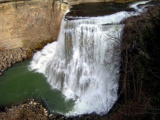
Burgess Falls State Park is a state park and state natural area in Putnam County and White County, Tennessee, located in the southeastern United States. The park is situated around a steep gorge in which the Falling Water River drops 250 feet (76 m) in elevation in less than a mile, culminating in a 136-foot (41 m) cataract waterfall.

<span class="mw-page-title-main">Dead River (Kennebec River tributary)</span> River in the United States

The Dead River, sometimes called the West Branch, is a 42.6-mile-long (68.6 km) river in central Maine in the United States. Its source is Flagstaff Lake, where its two main tributaries, South Branch Dead River and North Branch Dead River, join. It flows generally east to join the Kennebec River at The Forks, Maine.

<span class="mw-page-title-main">Carrabassett River</span> River in the United States

The Carrabassett River, a tributary of the Kennebec River, is located in Franklin County and Somerset County, Maine, in the United States. It rises near Sugarloaf Mountain, east of Rangeley Lake, and runs for 33.8 miles (54.4 km), flowing southeast past Kingfield and joining the Kennebec River in the town of Anson.

<span class="mw-page-title-main">Mount Bigelow (Maine)</span>

Mount Bigelow is a long mountain ridge with several summits. It is located in Franklin County and Somerset County, Maine. It is one of Maine's highest summits. The mountain is named after Major Timothy Bigelow who climbed the rugged summit in late October 1775 "for the purpose of observation." Major Bigelow was one of Colonel Benedict Arnold's four division commanders during the 1775 Invasion of Canada. The expeditionary force passed along the Dead River on the northern edge of the Bigelow Range, now dammed into Flagstaff Lake.

<span class="mw-page-title-main">Chicopee River</span> River in US

The Chicopee River is an 18.0-mile-long (29.0 km) tributary of the Connecticut River in the Pioneer Valley, Massachusetts, known for fast-moving water and its extraordinarily large basin: the Connecticut River's largest tributary basin. The Chicopee River originates in a Palmer, Massachusetts village called Three Rivers as a confluence of the Ware, Quaboag and Swift rivers. It passes through Wilbraham, Ludlow, and the Indian Orchard neighborhood of Springfield.

<span class="mw-page-title-main">Lake Wyola</span> Lake in Shutesbury, Massachusetts, US

Lake Wyola is a lake located in Shutesbury, Massachusetts, United States.

<span class="mw-page-title-main">Assiut Barrage</span> Dam in Asyut, Egypt

The Assiut Barrage is a dam on the Nile River in the city of Assiut in Upper Egypt. It was completed in 1903.

<span class="mw-page-title-main">Edwards Dam</span> Dam in Maine, USA

Edwards Dam was a hydroelectric dam on the Kennebec River in the U.S. state of Maine. It was located in Augusta, Maine, about 40 miles (64 km) upstream from the Atlantic Ocean. Built in 1837 of timber and concrete, it was 917 feet (280 m) long and 24 feet (7.3 m) high. It is most famous for its removal in 1999, the first removal of a hydroelectric dam by the government against the wishes of the dam owner.

<span class="mw-page-title-main">West Branch Penobscot River</span> River in the United States

The West Branch Penobscot River is a 117-mile-long (188 km) tributary of the Penobscot River through the North Maine Woods in Maine. The river is also known as Abocadneticook, Kahgognamock, and Kettegwewick.

<span class="mw-page-title-main">J. Strom Thurmond Dam</span> Dam in South Carolina, USA

J. Strom Thurmond Dam, also known in Georgia as Clarks Hill Dam, is a concrete-gravity and embankment dam located 22 miles (35 km) north of Augusta, Georgia on the Savannah River at the border of South Carolina and Georgia, creating Lake Strom Thurmond. U.S. Route 221 cross it. The dam was built by the U.S. Army Corps of Engineers between 1946 and 1954 for the purposes of flood control, hydroelectricity and downstream navigation. The concrete structure of the dam spans 1,096 feet (334 m) and rises 204 feet (62 m) above the riverbed, housing a power plant with an installed 380 MW capacity. The Dam has prevented over $3.1 million in estimated flood damage annually and also provides recreation, water quality, water supply, along with fish and wildlife management.

<span class="mw-page-title-main">Richard B. Russell Dam</span> Dam in Georgia, USA

Richard B. Russell Dam is a concrete-gravity and embankment dam located on the Savannah River at the border of South Carolina and Georgia, creating Richard B. Russell Lake. The dam was built by the U.S. Army Corps of Engineers between 1974 and 1985 for the purposes of flood control, hydroelectricity, recreation, additional stream flow regulation, water supply, and fish and wildlife management. The concrete structure of the dam spans 1,904 feet (580 m) and rises 210 feet (64 m) above the riverbed, housing a hydro-power plant with an installed 600 megawatts (800,000 hp) capacity. The Richard B. Russell Dam is the final large dam completed by the U.S. Army Corps in the Savannah River Basin and lies 30 miles downstream from the Hartwell Dam (1962) and 37 miles (60 km) upstream from the J. Strom Thurmond Dam (1954).

<span class="mw-page-title-main">Yeywa Dam</span> Hydropower station in Myanmar

The Yeywa Hydropower Station, located on the Myitnge River, 52 kilometres (32 mi) southeast of Mandalay city, at Yeywa village in Kyaukse Township, Mandalay Region in central Myanmar, is the country's first roller-compacted concrete (RCC) dam, and the site of a 790-megawatt (1,060,000 hp) hydroelectric power plant, the largest in the country.

<span class="mw-page-title-main">Pit 3 Dam</span> Dam in Shasta County, California

Pit-3 Dam is a hydroelectric dam on the Pit River in northern California in the United States. It forms Lake Britton, and is owned by the Pacific Gas and Electric Company (PG&E).

<span class="mw-page-title-main">Harris Station Dam</span> Hydroelectric dam in Maine

Harris Station Dam is a hydroelectric dam in Northeast Somerset, Somerset County, Maine. Also known as the Indian Pond Project, the dam was built from 1952 to 1954 as the largest hydroelectric dam in the state of Maine. It impounds the Kennebec River at the southern end of the natural Indian Pond, about 12 miles (19 km) downstream from Moosehead Lake.

<span class="mw-page-title-main">Enchanted Pond</span>

Enchanted Pond is a mountain pond in the U.S. state of Maine. Situated in the Western Maine Mountains in the Northwest Somerset Region, the pond is located in a deep mountain valley between Coburn Mountain and Shutdown Mountain. Near its southern end, the pond is distinguished by two rockslides from the exposed cliffs of these mountains that extend down into the water along both shores. Enchanted Pond is fed by mountain springs and Little Enchanted Pond, and is the primary source of Enchanted Stream which flows into the Dead River, a tributary of the Kennebec River. Development on the pond is limited to a small set of sporting camps at the northern end of the pond and one remote camp on the southwest shore, both a part of Bulldog Camps. There are no islands in the pond.

<span class="mw-page-title-main">Maranacook Lake</span> Mesotrophicic, reservoir in Kennebec County, Maine

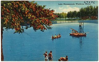
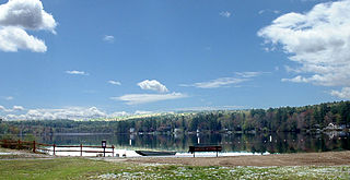
Maranacook Lake is a lake in Kennebec County, Maine located in the towns of Readfield and Winthrop. The lake covers 1,673 acres (677 ha) with a maximum depth of 118 feet (36 m) and a mean depth of 30 feet (9.1 m). It is one of the major bodies of water in the Winthrop Lakes Region.

<span class="mw-page-title-main">Moore Dam</span> Dam on the border of New Hampshire and Vermont

Moore Dam is a major hydroelectric dam on the Upper Connecticut River between Grafton County, New Hampshire and Caledonia County, Vermont in the northeastern United States. The dam is located near Littleton, New Hampshire, and forms the 3,490-acre (1,410 ha) Moore Reservoir. The Moore Station is the largest conventional hydroelectric plant in New England, in terms of installed capacity and average power generation. The dam and reservoir also provide flood control, recreational boating and fishing.

References

  1. Maine Fishing Depth Maps: Lakes & Ponds by County. DeLorme. 2007. ISBN   978-0-89933-350-2.
  2. Patrick, Ruth (1994). Rivers of the United States: The eastern and southeastern states; Volume 3 of Rivers of the United States. John Wiley and Sons. p. 74. ISBN   978-0-471-30346-6.
  3. "The Northern: The Way I Remember" (PDF). John E. Mcleod. Retrieved 2012-12-19.
  4. Lost Villages of Flagstaff Lake, bBy Alan L. Burnell, Kenny R. Wing, page 9
  5. "Flagstaff, "Man Made Lake" - Maine Folklife Center - University of Maine".
  6. "Federal Register, Volume 61 Issue 175 (Monday, September 9, 1996)".
  7. "Conservation group accuses DEP of intentionally relinquishing oversight of Flagstaff Lake". 4 January 2012.
  8. Maine's Multiple Use River: Kennebec River, Past and Present. Kennebec Water Power Co. Lewiston, Maine
  9. "Long Falls Dam, Maine 1991-2020 Monthly Normals" . Retrieved October 26, 2023.
  10. "xmACIS". National Oceanic and Atmospheric Administration. Retrieved October 26, 2023.
  11. "T-33A crash mystery". Pete Noddin. Archived from the original on 2007-12-11. Retrieved 2012-01-20.