Caratunk is a town in Somerset County, Maine, United States. The population was 81 at the 2020 census.

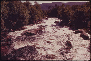
The Kennebec River is a 170-mile-long (270 km) river within the U.S. state of Maine. It rises in Moosehead Lake in west-central Maine. The East and West Outlets join at Indian Pond and the river flows southward. Harris Station Dam, the largest hydroelectric dam in the state, was constructed near that confluence. The river is joined at The Forks by its tributary the Dead River, also called the West Branch.
The Magalloway River is a river in northwestern Maine and northern New Hampshire in the United States. It is a tributary of the Androscoggin River, which flows to the Kennebec River at Merrymeeting Bay in Maine, near the Atlantic Ocean. The total length of the river is 30 miles (48 km), or 48 miles (77 km) if the distances across intervening lakes are included.
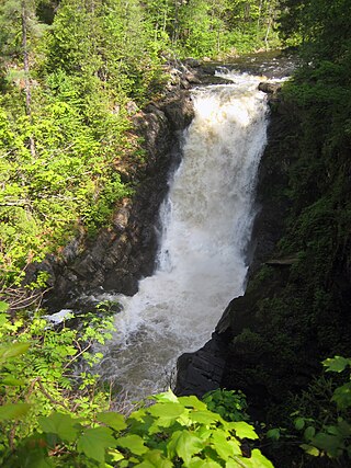
Moxie Falls is a waterfall in Somerset County, Maine. At a vertical drop of over 90 feet (30 m) into a pool about 17 feet (5 m) deep, Moxie Falls is one of the highest falls in New England. The falls are part of Moxie Stream which flows from Moxie Pond into the Kennebec River approximately 1 kilometer (0.62 mi) downstream the falls. Moxie Stream drains Moxie Pond approximately 5 miles (8.0 km) upstream of the falls.

The Sebasticook River is a 76-mile-long (122 km) river in the central part of Maine, in the United States. From its source in Dexter, the upper "Main Stream" section flows generally west and south 30 miles (48 km) to Great Moose Lake. From the outlet of the lake in Hartland, the Sebasticook flows 41 miles (66 km) south to the Kennebec River in Winslow.
The Little Androscoggin River is a 51.4-mile-long (82.7 km) river in Maine. It flows from Bryant Pond in Woodstock to its confluence with the Androscoggin River in Auburn. The Androscoggin flows into Merrymeeting Bay in the Kennebec River estuary.

The Medomak River, historically known as the Muscongus River, is a 40-mile-long (64 km) river in Maine. From its source in Liberty, the river winds 32 miles (51 km) south to the head of its tidal river estuary in Waldoboro, then about 8 miles (13 km) south to Bremen. The river flows through Hockomock Channel into the head of Muscongus Bay. Medomak is Abenaki for "place (river) of many alewives".

The Moose River is an 83-mile-long (134 km) river in Maine. Its source is in Beattie, on the Canada–United States border, which runs along the height of land between the watersheds of the Kennebec River in Maine and the Chaudière River in Quebec. From there, the river runs east through Attean Pond and Wood Pond, past the town of Moose River, then through Long Pond and Brassua Lake. The Moose River empties into Moosehead Lake, the source of the Kennebec River, in Rockwood Strip. The International Railway of Maine was built along Moose River in 1889.
The Roach River is a river in Piscataquis County, Maine. From the outlet of Third Roach Pond in Shawtown, the river runs 19.1 miles (30.7 km) west, through a chain of ponds. The Flow sequence through the ponds is from the Fourth Roach Pond through the Third Roach Pond, Second Roach Pond, and First Roach Pond to empty into Moosehead Lake, the source of the Kennebec River, in Spencer Bay. The Seventh Roach Pond drains through the Sixth Roach Pond in a separate tributary to the Third Roach Pond. No fifth Roach Pond is shown on modern maps.
The South Branch Penobscot River is a river in Somerset County, Maine. Its source, Penobscot lake, the north end of which at is about 1,000 feet (300 m) from the Canada–United States border in Sandy Bay. This section of the border runs along the height of land separating the watersheds of the Penobscot River and the Monument River, which feeds into the Saint Lawrence River.

The West Branch Penobscot River is a 117-mile-long (188 km) tributary of the Penobscot River through the North Maine Woods in Maine. The river is also known as Abocadneticook, Kahgognamock, and Kettegwewick.
Chamberlain Lake is one of the largest and deepest lakes in the North Maine Woods. The lake originally drained north through Eagle Lake and Churchill Lake into the Allagash River tributary to the Saint John River. Nineteenth-century logging operations diverted the lake into the Penobscot River before designation of the Allagash Wilderness Waterway in 1966.
Upper Richardson Lake and Lower Richardson Lake are impounded as a single reservoir by Middle Dam at the outlet to Rapid River on the western shore of the lower lake. Rapid River flows 5 miles (8.0 km) to Umbagog Lake headwaters of the Androscoggin River. Upper Richardson Lake is in the western portion of Richardsontown township, and the lower lake is on the border of Magalloway and Maine Township C. Primary inflow is discharge over Upper Dam on Mooselookmeguntic Lake on the eastern shore of the upper lake. Smaller tributaries entering the north end of the upper lake include Mill Brook draining the Richardson Ponds, Fish Brook draining Fish Pond, and Beaver Brook draining Beaver Pond, Little Beaver Pond, and Aziscohos Pond. Other small tributaries include Rand Brook on the western shore, and Mosquito Brook, Metallak Brook, and Bailey Brook on the eastern shore. The lake offers excellent habitat for adult trout, but with dams on the outlet and major inlet, fish populations are limited by the insufficient spawning and nursery areas of these small tributaries. The public boat launch area at the north end of the upper lake is 1 mile (1.6 km) off Maine State Route 16; and the boat launch area at the south end of the lower lake is accessed by driving 12 miles (19 km) north of Andover on South Arm Road.
The Belgrade Lakes are a chain of lakes around Belgrade, Maine. The flow sequence is from East Pond to North Pond to Great Pond to Long Pond to Messalonskee Lake and thence via Messalonskee Stream to the Kennebec River at Waterville. The lakes have long been an important resort area for fishing, boating, and swimming; and shoreline development includes residences for individuals employed in the cities of Waterville and Augusta.
Millinocket Lake is the source of Millinocket Stream in the North Maine Woods north of Baxter State Park. Millinocket Stream flows 5.5 miles (8.9 km) to Maine township 8, range 8, where it joins Munsungan Stream to form the Aroostook River. The lake extending along the border of Maine range 9 townships 7 and 8 is impounded behind a wooden dam. The dam enlarged the lake to include Little Millinocket Lake and Moose Pond by flooding adjoining bogs to store water for hydropower. The large areas of shallow flooded bog are a good habitat for fallfish, yellow perch and white suckers; but with summer water temperatures ranging from 70° near the surface to 55° in the deeper areas, dissolved oxygen concentrations become unfavorable for trout. Tributaries to the lake drain a number of small ponds to the west of the lake including Atkins Pond, Blackmore Pond, Buckley Pond, Big Caribou Pond, Little Caribou Pond, Chandler Pond, Elsie Pond, Ervin Pond, Jack Pond, Kyle Pond, Line Pond, Mathews Pond, May Pond, Little Moose Pond, Upper Moose Pond, Pretty Pond, Snowshoe Pond, and Spring Pond.
Spencer Lake extends southward from Fish Pond in Hobbstown township into Maine township 3, range 5. The north end of the lake receives drainage from Whipple Bog, Whipple Pond, Hall Pond, Toby Pond, and Chub Pond through Fish Pond. The south end of the lake overflows through Little Spencer Stream and thence Spencer Stream 6 miles (9.7 km) to the Dead River 14 miles (23 km) upstream of the confluence with the Kennebec River at The Forks. The lake supports a native population of lake trout and brook trout, and has been stocked with land-locked Atlantic salmon. There is a boat launch area at the north end of the lake accessible from a 2-mile (3.2 km) gravel road 11 miles (18 km) west off U.S. Route 201 at Parlin Pond.
A chain of three Jo-Mary Lakes along the border of Penobscot County and Piscataquis County drain into the Pemadumcook Chain of Lakes in the North Maine Woods. The flow sequence is from Upper Jo-Mary Lake into Middle Jo-Mary Lake and then through Lower Jo-Mary Lake into Pemadumcook Lake.
The chain of Debsconeag Lakes in the North Maine Woods is a tributary to the West Branch Penobscot River. The flow sequence is from the Sixth Debsconeag Lake through the Fifth, Fourth, Third, Second, and First into the Debsconeag Deadwater on the West Branch.
Hancock Brook is an east-bank tributary to the Saco River at Hiram, Maine. The brook originates in eastern Denmark and flows through a chain of ponds along the border between Hiram and Sebago. The narrow-gauge Bridgton and Saco River Railroad was built along the brook in 1882, and operated until 1941.
The Saint John Ponds are a chain of shallow lakes at the headwaters of the Baker Branch Saint John River in the North Maine Woods. The flow sequence is from the Upper First Saint John Pond, through the Lower First Saint John Pond, Second Saint John Pond, Third Saint John Pond, and Fourth Saint John Pond to the Fifth Saint John Pond. Flow from one pond to the next is sometimes called Baker Stream rather than the Baker Branch Saint John River. Great Northern Paper Company dug a canal from Fifth Saint John Pond 2 miles (3.2 km) westward to the North Branch Penobscot River in 1939, and built a dam at the north end of Fifth Saint John Pond so pulpwood logs harvested in the upper Saint John River watershed could be floated down the Penobscot River to Millinocket, Maine. The canal and dam have fallen into disrepair so most drainage from the ponds again flows down the Saint John River. All upstream ponds with the exception of the first had dams to regulate discharge flow for log driving, but those dams have similarly fallen into disrepair. Moose use the ponds as summer refuge from heat and biting insects.

