Clinton, Maine

Last updated

Clinton, Maine
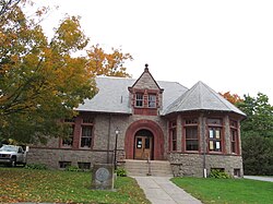
Clinton, Maine (8166531601).jpg
Kennebec County Maine incorporated and unincorporated areas Clinton highlighted.svg
Location in Kennebec County and the state of Maine.
Coordinates: 44°38′18″N69°29′59″W / 44.638368°N 69.499741°W / 44.638368; -69.499741
CountryUnited States
State Maine
County Kennebec
Villages Clinton
Morrison Corner
Area
[1]
  Total44.79 sq mi (116.01 km2)
  Land43.87 sq mi (113.62 km2)
  Water0.92 sq mi (2.38 km2)
Population
 (2020)
  Total3,370
  Density77/sq mi (29.7/km2)
Time zone UTC-5 (Eastern (EST))
  Summer (DST) UTC-4 (EDT)
Area code Area code
Website www.clinton-me.us

Clinton is a town in Kennebec County, Maine, United States. The town was named for New York Governor DeWitt Clinton. [2] The population was 3,370 at the 2020 census. [3] The main village in town is the Clinton census-designated place, with a population of 1,386 at the 2020 census. [4]

Contents

Geography

According to the United States Census Bureau, the town has a total area of 44.79 square miles (116.01 km2), of which 43.87 square miles (113.62 km2) is land and 0.92 square miles (2.38 km2) is water. [1]

The town is bordered by Skowhegan and Canaan on the north, Pittsfield on the northeast, Burnham on the east, Benton on the south and Fairfield on the west. It is the northernmost town in Kennebec County: towns to the west and north are in Somerset County, while Waldo County is to the east.

Clinton is crossed by Interstate 95, SR 11, SR 100 and SR 23. The village of Clinton is in the southeast part of the town, on the north side of the Sebasticook River, a southwest-flowing tributary of the Kennebec River.

Demographics

Historical population
CensusPop.Note
1800 533
1810 1,05097.0%
1820 1,35629.1%
1830 2,12456.6%
1840 2,81832.7%
1850 1,743−38.1%
1860 1,8033.4%
1870 1,766−2.1%
1880 1,665−5.7%
1890 1,518−8.8%
1900 1,398−7.9%
1910 1,268−9.3%
1920 1,230−3.0%
1930 1,35410.1%
1940 1,4366.1%
1950 1,62313.0%
1960 1,7296.5%
1970 1,97114.0%
1980 2,69636.8%
1990 3,31222.8%
2000 3,3400.8%
2010 3,4864.4%
2020 3,370−3.3%
U.S. Decennial Census [5]

2010 census

As of the census [6] of 2010, there were 3,486 people, 1,412 households, and 962 families living in the town. The population density was 79.5 inhabitants per square mile (30.7/km2). There were 1,547 housing units at an average density of 35.3 per square mile (13.6/km2). The racial makeup of the town was 97.1% White, 0.4% African American, 0.6% Native American, 0.1% Asian, 0.5% from other races, and 1.2% from two or more races. Hispanic or Latino of any race were 1.1% of the population.

There were 1,412 households, of which 32.3% had children under the age of 18 living with them, 52.8% were married couples living together, 10.3% had a female householder with no husband present, 5.0% had a male householder with no wife present, and 31.9% were non-families. 24.4% of all households were made up of individuals, and 8.2% had someone living alone who was 65 years of age or older. The average household size was 2.47 and the average family size was 2.88.

The median age in the town was 40.5 years. 22.9% of residents were under the age of 18; 7.9% were between the ages of 18 and 24; 26.1% were from 25 to 44; 31.1% were from 45 to 64; and 12.2% were 65 years of age or older. The gender makeup of the town was 51.1% male and 48.9% female.

2000 census

As of the census [7] of 2000, there were 3,340 people, 1,278 households, and 953 families living in the town. The population density was 76.1 inhabitants per square mile (29.4/km2). There were 1,409 housing units at an average density of 32.1 per square mile (12.4/km2). The racial makeup of the town was 98.08% White, 0.12% Black or African American, 0.21% Native American, 0.06% Asian, 0.18% from other races, and 1.35% from two or more races. Hispanic or Latino of any race were 0.96% of the population.

There were 1,278 households, out of which 36.0% had children under the age of 18 living with them, 59.2% were married couples living together, 9.2% had a female householder with no husband present, and 25.4% were non-families. 19.0% of all households were made up of individuals, and 6.8% had someone living alone who was 65 years of age or older. The average household size was 2.61 and the average family size was 2.95.

In the town, the population was spread out, with 26.6% under the age of 18, 8.8% from 18 to 24, 30.4% from 25 to 44, 24.7% from 45 to 64, and 9.5% who were 65 years of age or older. The median age was 36 years. For every 100 females, there were 101.0 males. For every 100 females age 18 and over, there were 97.4 males.

The median income for a household in the town was $32,419, and the median income for a family was $37,652. Males had a median income of $28,667 versus $21,051 for females. The per capita income for the town was $15,052. About 10.1% of families and 13.0% of the population were below the poverty line, including 16.3% of those under age 18 and 6.6% of those age 65 or over.
Claim to Fame

Clinton is the dairy capital of Maine; with 13% of milk production coming from 7 farms consisting of 3,778 acres.

Fedco Seeds is headquartered in Clinton.

Related Research Articles

<span class="mw-page-title-main">Kennebec County, Maine</span> County in Maine, United States

Kennebec County is a county located in the South-central portion of the U.S. state of Maine. At the 2020 census, the population was 123,642. Its county seat is Augusta, the state capital. The county was established on February 20, 1799, from portions of Cumberland and Lincoln Counties. The name Kennebec comes from the Eastern Abenaki /kínipekʷ/, meaning "large body of still water, large bay."

<span class="mw-page-title-main">New Sharon, Maine</span> Town in the state of Maine, United States

New Sharon is a town in Franklin County, Maine, incorporated in 1794. The population was 1,458 at the 2020 census. The town is roughly bisected by the Sandy River, a tributary of the Kennebec River.

<span class="mw-page-title-main">Albion, Maine</span> Town in the state of Maine, United States

Albion is a town in Kennebec County, Maine, United States. The population was 2,006 at the 2020 census.

<span class="mw-page-title-main">Benton, Maine</span> Town in the state of Maine, United States

Benton is a town in Kennebec County, Maine, United States. It was formed in 1842, as a subdivision of the town of Clinton. The population was 2,715 at the 2020 census. The town was named for Missouri Senator Thomas Hart Benton.

<span class="mw-page-title-main">Chelsea, Maine</span> Town in the state of Maine, United States

Chelsea is a town in Kennebec County, Maine, United States. The population was 2,778 at the 2020 census. It is home to the Togus Veterans Administration facilities.

<span class="mw-page-title-main">Fayette, Maine</span> Town in the state of Maine, United States

Fayette is a town in Kennebec County, Maine, United States. The population was 1,160 as of the 2020 census. A popular recreation spot in central Maine, Fayette is part of the Winthrop Lakes Region.

<span class="mw-page-title-main">Litchfield, Maine</span> Town in the state of Maine, United States

Litchfield is a town in Kennebec County, Maine, United States. The population was 3,586 at the 2020 census. Litchfield is included in the Augusta, Maine micropolitan New England City and Town Area.

<span class="mw-page-title-main">Manchester, Maine</span> Town in Maine, United States

Manchester is a town in Kennebec County, Maine, United States, located at 44.33°N 69.87°W. The population was 2,456 at the 2020 census. The southern part of the town bordering Cobbosseecontee Lake is a popular recreation spot in central Maine, and part of the Winthrop Lakes Region. Manchester is included in the Augusta, Maine micropolitan New England City and Town Area.

<span class="mw-page-title-main">Monmouth, Maine</span> Town in the state of Maine, United States

Monmouth is a town in Kennebec County, Maine, United States. The population was 4,066 at the 2022 census.

<span class="mw-page-title-main">Mount Vernon, Maine</span> Town in the state of Maine, United States

Mount Vernon is a town in Kennebec County, Maine, United States. The population was 1,721 at the 2020 census. Mount Vernon is included in the Augusta, Maine micropolitan New England City and Town Area. A popular recreation spot in central Maine, the northern area of Mount Vernon is part of the Belgrade Lakes Region, while the southern area is part of the Winthrop Lakes Region.

<span class="mw-page-title-main">Pittston, Maine</span> Town in the state of Maine, United States

Pittston is a town in Kennebec County, Maine, United States. The population was 2,875 at the 2020 census. The town was named after the family of John Pitt, who were early settlers. Pittston is included in the Augusta, Maine micropolitan New England City and Town Area.

<span class="mw-page-title-main">Sidney, Maine</span> Town in the state of Maine, United States

Sidney is a town in Kennebec County, Maine, United States. The population was 4,645 at the 2020 census. Sidney was incorporated as a town on January 30, 1792. The town was named for Sir Philip Sidney, an English author. Sidney is included in the Augusta, Maine micropolitan New England City and Town Area. Since 1937, the town has been the home of the New England Music Camp.

<span class="mw-page-title-main">Vienna, Maine</span> Town in the state of Maine, United States

Vienna is a town in Kennebec County, Maine, United States. The population was 578 at the 2020 census.

<span class="mw-page-title-main">Wayne, Maine</span> Town in the state of Maine, United States

Wayne is a town in Kennebec County, Maine, United States. The population was 1,129 at the 2020 census. The town was named after Revolutionary War General Anthony Wayne. During the summer, Wayne is home to Camp Androscoggin. A popular recreation spot in central Maine, Wayne is part of the Winthrop Lakes Region. The town is included in the Augusta, Maine micropolitan New England City and Town Area.

<span class="mw-page-title-main">West Gardiner, Maine</span> Town in the state of Maine, United States

West Gardiner is a town in Kennebec County, Maine, United States. The population was 3,671 at the 2020 census. West Gardiner is included in the Augusta, Maine micropolitan New England City and Town Area.

<span class="mw-page-title-main">Windsor, Maine</span> Town in the state of Maine, United States

Windsor is a town in Kennebec County, Maine, United States. The population was 2,632 at the 2020 census. Windsor is included in the Augusta, Maine micropolitan New England City and Town Area.

<span class="mw-page-title-main">West Bath, Maine</span> Town in the state of Maine, United States

West Bath is a town in Sagadahoc County, Maine, United States. The population was 1,910 at the 2020 census. A sub-locality of West Bath is Winnegance. West Bath is part of the Portland–South Portland–Biddeford, Maine metropolitan statistical area.

<span class="mw-page-title-main">Randolph, Maine</span> Town in the state of Maine, United States

Randolph is a town and a census-designated place (CDP) in Kennebec County, Maine, United States. The population was 1,743 at the 2020 census. The town was named for Randolph, Massachusetts. Randolph is included in the Augusta, Maine micropolitan New England City and Town Area.

<span class="mw-page-title-main">Oakland, Maine</span> Town in the state of Maine, United States

Oakland is a town in Kennebec County in the U.S. state of Maine. The population was 6,230 at the 2020 census. Oakland is 4 miles (6 km) west of Waterville and approximately 18 miles (29 km) north of Augusta, the state capital. Waterville and Augusta are service centers for Oakland, and many Oakland residents commute to jobs in those areas.

<span class="mw-page-title-main">Clinton (CDP), Maine</span> Census-designated place in Maine, United States

Clinton is a census-designated place (CDP) and the primary village in the town of Clinton in Kennebec County, Maine, United States. The population was 1,419 at the 2010 census, out of 3,486 in the entire town of Clinton.

References

  1. 1 2 "US Gazetteer files 2010". United States Census Bureau . Retrieved December 16, 2012.
  2. "Profile for Clinton, Maine". ePodunk . Retrieved April 26, 2010.
  3. "Census - Geography Profile: Clinton town, Kennebec County, Maine" . Retrieved January 15, 2022.
  4. "Census - Geography Profile: Clinton CDP, Maine" . Retrieved January 15, 2022.
  5. "Census of Population and Housing". Census.gov. Retrieved June 4, 2015.
  6. "U.S. Census website". United States Census Bureau . Retrieved December 16, 2012.
  7. "U.S. Census website". United States Census Bureau . Retrieved 2008-01-31.

The Town of Clinton was incorporated in 1795, within the Commonwealth of Massachusetts; and, later became Clinton, Maine, on March 15, 1820, when the State of Maine was accepted as a State within the United States of America.

The Town was apparently named after Revolutionary War General, and U.S. vice president, George Clinton. (Note: the Town is not named for Dewitt Clinton, who was born in 1769 and attained his first elective office in the New York state legislature in 1799, several years before becoming New York's governor).