Winthrop (CDP), Maine

Last updated

Winthrop, Maine
Kennebec County Maine incorporated and unincorporated areas Winthrop (CDP) highlighted.svg
Location in Kennebec County and the state of Maine
Coordinates: 44°18′43″N69°58′7″W / 44.31194°N 69.96861°W / 44.31194; -69.96861
CountryUnited States
State Maine
County Kennebec
Town Winthrop
Area
[1]
  Total7.20 sq mi (18.64 km2)
  Land5.53 sq mi (14.32 km2)
  Water1.67 sq mi (4.32 km2)
Elevation
230 ft (70 m)
Population
 (2020)
  Total2,666
  Density482.18/sq mi (186.17/km2)
Time zone UTC-5 (Eastern (EST))
  Summer (DST) UTC-4 (EDT)
ZIP code
04364
Area code 207
FIPS code 23-86935
GNIS feature ID0578610

Winthrop is a census-designated place (CDP) comprising the primary settlement in the town of Winthrop in Kennebec County, Maine, United States. The population was 2,650 at the 2010 census, [2] out of 6,092 in the town of Winthrop as a whole.

Contents

Geography

Winthrop is located in southwestern Kennebec County at 44°18′42″N69°58′7″W / 44.31167°N 69.96861°W / 44.31167; -69.96861 (44.311812, −69.968699), [3] in the center of the town of Winthrop. The village is in the Winthrop Lakes Region and sits between the outlet of Maranacook Lake and the inlet of Annabessacook Lake along their connecting stream, which falls 40 feet (12 m) in 0.6 miles (0.97 km). The CDP includes rural land surrounding the village, extending east to the shore of Upper Narrows Pond, south down Annabessacook Lake to the inlet of Hoyt Brook, north up Maranacook Lake to the Readfield town line, and west along Hoyt Brook and Maine State Route 41.

U.S. Route 202, with Maine State Routes 11 and 100, passes through the central part of the CDP, passing just south of the village center. US 202 leads east 10 miles (16 km) to Augusta, the state capital, and southwest 19 miles (31 km) to Lewiston. Routes 41 and 133 pass through the village center. Route 41 leads north 6 miles (10 km) to the center of Readfield, while Route 133 leads northwest 17 miles (27 km) to Livermore Falls.

According to the United States Census Bureau, the Winthrop CDP has a total area of 7.2 square miles (18.7 km2), of which 5.6 square miles (14.4 km2) are land and 1.6 square miles (4.2 km2), or 22.58%, are water. [2] The Winthrop Lakes network drains via Cobbosseecontee Lake and Stream southeast to the Kennebec River at Gardiner.

Demographics

Historical population
CensusPop.Note
2020 2,666
U.S. Decennial Census [4]

As of the census [5] of 2000, there were 2,893 people, 1,188 households, and 780 families residing in the CDP. The population density was 520.7 inhabitants per square mile (201.0/km2). There were 1,344 housing units at an average density of 241.9 per square mile (93.4/km2). The racial makeup of the CDP was 98.00% White, 0.52% Black or African American, 0.35% Native American, 0.38% Asian, 0.07% from other races, and 0.69% from two or more races. Hispanic or Latino of any race were 0.41% of the population.

There were 1,188 households, out of which 29.4% had children under the age of 18 living with them, 51.2% were married couples living together, 11.9% had a female householder with no husband present, and 34.3% were non-families. 28.0% of all households were made up of individuals, and 10.2% had someone living alone who was 65 years of age or older. The average household size was 2.30 and the average family size was 2.81.

In the CDP the population was spread out, with 21.7% under the age of 18, 6.5% from 18 to 24, 25.5% from 25 to 44, 25.3% from 45 to 64, and 21.0% who were 65 years of age or older. The median age was 43 years. For every 100 females there were 95.6 males. For every 100 females age 18 and over, there were 91.5 males.

The median income for a household in the CDP was $38,403, and the median income for a family was $47,875. Males had a median income of $33,826 versus $26,732 for females. The per capita income for the CDP was $19,075. About 7.2% of families and 9.6% of the population were below the poverty line, including 12.4% of those under age 18 and 10.8% of those age 65 or over.

Related Research Articles

<span class="mw-page-title-main">Kennebec County, Maine</span> County in Maine, United States

Kennebec County is a county located in the South-central portion of the U.S. state of Maine. At the 2020 census, the population was 123,642. Its county seat is Augusta, the state capital. The county was established on February 20, 1799, from portions of Cumberland and Lincoln Counties. The name Kennebec comes from the Eastern Abenaki /kínipekʷ/, meaning "large body of still water, large bay."

<span class="mw-page-title-main">Belgrade, Maine</span> Town in the state of Maine, United States

Belgrade is a town in Kennebec County, Maine, United States. Its population was 3,250 at the 2020 census. However, its population approximately doubles during the summer months as part-year residents return to seasonal camps on the shores of Great Pond, Long Pond and Messalonskee Lake. Belgrade includes the villages of North Belgrade, Belgrade Depot and Belgrade Lakes. It is included in the Augusta, Maine micropolitan New England City and Town Area.

<span class="mw-page-title-main">Fayette, Maine</span> Town in the state of Maine, United States

Fayette is a town in Kennebec County, Maine, United States. The population was 1,160 as of the 2020 census. A popular recreation spot in central Maine, Fayette is part of the Winthrop Lakes Region.

<span class="mw-page-title-main">Manchester, Maine</span> Town in Maine, United States

Manchester is a town in Kennebec County, Maine, United States, located at 44.33°N 69.87°W. The population was 2,456 at the 2020 census. The southern part of the town bordering Cobbosseecontee Lake is a popular recreation spot in central Maine, and part of the Winthrop Lakes Region. Manchester is included in the Augusta, Maine micropolitan New England City and Town Area.

<span class="mw-page-title-main">Monmouth, Maine</span> Town in the state of Maine, United States

Monmouth is a town in Kennebec County, Maine, United States. The population was 4,066 at the 2022 census.

<span class="mw-page-title-main">Mount Vernon, Maine</span> Town in the state of Maine, United States

Mount Vernon is a town in Kennebec County, Maine, United States. The population was 1,721 at the 2020 census. Mount Vernon is included in the Augusta, Maine micropolitan New England City and Town Area. A popular recreation spot in central Maine, the northern area of Mount Vernon is part of the Belgrade Lakes Region, while the southern area is part of the Winthrop Lakes Region.

<span class="mw-page-title-main">Readfield, Maine</span> Town in the state of Maine, United States

Readfield is a town in Kennebec County, Maine, United States. The population was 2,597 at the 2020 census. Readfield is home to the Kents Hill School, a preparatory school, Maranacook Community Schools, public schools for the district, a few summer camps, and the annual Readfield Heritage Days. A popular recreation spot in central Maine, the town contains nine lakes and ponds, including Maranacook Lake, and is part of the Winthrop Lakes Region. The town of Readfield was previously named Pond Town. Readfield is included in the Augusta, Maine micropolitan New England City and Town Area.

<span class="mw-page-title-main">Wayne, Maine</span> Town in the state of Maine, United States

Wayne is a town in Kennebec County, Maine, United States. The population was 1,129 at the 2020 census. The town was named after Revolutionary War General Anthony Wayne. During the summer, Wayne is home to Camp Androscoggin. A popular recreation spot in central Maine, Wayne is part of the Winthrop Lakes Region. The town is included in the Augusta, Maine micropolitan New England City and Town Area.

<span class="mw-page-title-main">Lake Bosworth, Washington</span> CDP in Washington, United States

Lake Bosworth is a census-designated place (CDP) in Snohomish County, Washington, United States. The population was 667 at the 2010 census.

<span class="mw-page-title-main">Farmington (CDP), Maine</span> Census-designated place in Maine, United States

Farmington is a census-designated place (CDP) comprising the center of the town of Farmington, which is the county seat of Franklin County in Maine, United States. The population of the CDP was 4,288 at the 2010 census, out of 7,760 people in the town as a whole. The University of Maine at Farmington is located within the CDP.

<span class="mw-page-title-main">Clinton (CDP), Maine</span> Census-designated place in Maine, United States

Clinton is a census-designated place (CDP) and the primary village in the town of Clinton in Kennebec County, Maine, United States. The population was 1,419 at the 2010 census, out of 3,486 in the entire town of Clinton.

<span class="mw-page-title-main">Farmingdale (CDP), Maine</span> Census-designated place in Maine, United States

Farmingdale is a census-designated place (CDP) in the town of Farmingdale in Kennebec County, Maine, United States. The population was 1,970 at the 2010 census, out of 2,956 in the entire town.

<span class="mw-page-title-main">Oakland (CDP), Maine</span> Census-designated place in Maine, United States

Oakland is a census-designated place (CDP) comprising the main population center in the town of Oakland in Kennebec County, Maine, United States. The population was 2,602 at the 2010 census, out of 6,240 in the entire town of Oakland.

<span class="mw-page-title-main">Winthrop, Maine</span> Town in Maine, United States

Winthrop is a town in Kennebec County, Maine, United States. The population was 6,121 at the 2020 census. Winthrop's population, however, approximately doubles during the summer months as part-year residents return to seasonal camps located on the shores of Winthrop's Lakes and Ponds. A recreational area located among lakes, the town includes the villages of Winthrop and East Winthrop, and is the center of the Winthrop Lakes Region. Winthrop is included in the Augusta, Maine Micropolitan New England City and Town Area.

<span class="mw-page-title-main">Camden (CDP), Maine</span> Census-designated place in Maine, United States

Camden is a census-designated place (CDP) comprising the main village in the town of Camden in Knox County, Maine, United States. The population was 3,570 at the 2010 census, out of 4,850 in the entire town of Camden.

<span class="mw-page-title-main">Waldoboro (CDP), Maine</span> Census-designated place in Maine, United States

Waldoboro is a census-designated place (CDP) comprising the central village in the town of Waldoboro in Lincoln County, Maine, United States. The population was 1,300 at the 2020 census, out of 5,075 people in the entire town of Waldoboro.

<span class="mw-page-title-main">Wiscasset (CDP), Maine</span> Census-designated place in Maine, United States

Wiscasset is a census-designated place (CDP) comprising the primary settlement in the town of Wiscasset in Lincoln County, Maine, United States. The population was 1,232 at the 2020 census, out of 3,732 people in the entire town. Wiscasset is the county seat of Lincoln County.

<span class="mw-page-title-main">Fairfield (CDP), Maine</span> CDP in Maine, United States

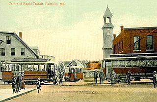
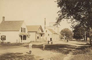
Fairfield is a census-designated place (CDP) in the town of Fairfield in Somerset County, Maine, United States. The population was 2,569 at the 2000 census.

<span class="mw-page-title-main">Maranacook Lake</span> Mesotrophicic, reservoir in Kennebec County, Maine

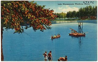
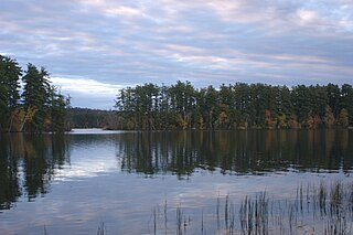
Maranacook Lake is a lake in Kennebec County, Maine located in the towns of Readfield and Winthrop. The lake covers 1,673 acres (677 ha) with a maximum depth of 118 feet (36 m) and a mean depth of 30 feet (9.1 m). It is one of the major bodies of water in the Winthrop Lakes Region.

<span class="mw-page-title-main">Skowhegan (CDP), Maine</span> CDP in Maine, United States

Skowhegan is a census-designated place (CDP) in the town of Skowhegan in Somerset County, Maine, United States. The population was 6,404 at the 2020 census.

References

  1. "2020 U.S. Gazetteer Files". United States Census Bureau. Retrieved April 8, 2022.
  2. 1 2 "Geographic Identifiers: 2010 Census Summary File 1 (G001), Winthrop CDP, Maine". American FactFinder. U.S. Census Bureau. Archived from the original on February 13, 2020. Retrieved March 11, 2019.
  3. "US Gazetteer files: 2010, 2000, and 1990". United States Census Bureau. February 12, 2011. Retrieved April 23, 2011.
  4. "Census of Population and Housing". Census.gov. Retrieved June 4, 2016.
  5. "U.S. Census website". United States Census Bureau . Retrieved January 31, 2008.