Oakland (CDP), Maine

Last updated

Oakland, Maine
Kennebec County Maine incorporated and unincorporated areas Oakland (CDP) highlighted.svg
Location in Kennebec County and the state of Maine
Coordinates: 44°32′50″N69°42′47″W / 44.54722°N 69.71306°W / 44.54722; -69.71306
CountryUnited States
State Maine
County Kennebec
Town Oakland
Area
[1]
  Total5.71 sq mi (14.78 km2)
  Land5.41 sq mi (14.00 km2)
  Water0.30 sq mi (0.78 km2)
Elevation
233 ft (71 m)
Population
 (2020)
  Total2,536
  Density469.11/sq mi (181.11/km2)
Time zone UTC-5 (Eastern (EST))
  Summer (DST) UTC-4 (EDT)
ZIP code
04963
Area code 207
FIPS code 23-54525
GNIS feature ID0572648

Oakland is a census-designated place (CDP) comprising the main population center in the town of Oakland in Kennebec County, Maine, United States. The population was 2,602 at the 2010 census, [2] out of 6,240 in the entire town of Oakland.

Contents

Geography

The CDP is in northern Kennebec County, in the eastern part of the town of Oakland at 44°32′25″N69°43′19″W / 44.54028°N 69.72194°W / 44.54028; -69.72194 . [3] It sits along Messalonskee Stream at the outlet of Messalonskee Lake. The village center is on the north side of the stream, but developed land exists on both sides. The CDP extends east to the Waterville city line, north to Red Brook, a west-side tributary of Messalonskee Stream, west to Ten Oaks Road, South Gage Road, and Wiley Point Road, and south to Webb Road.

Maine State Route 23 passes north-south through the community, and Maine State Route 137 passes through east-west, crossing Route 23 in the village center. Maine State Route 11 enters from the southwest and exits to the east with Route 137. Interstate 95 passes just to the east, with access from Exit 127 (Routes 11 and 137). I-95 leads northeast 58 miles (93 km) to Bangor and south 18 miles (29 km) to Augusta, the state capital. Downtown Waterville is 4 miles (6 km) to the east of Oakland via Routes 11 and 137.

According to the United States Census Bureau, the Oakland CDP has a total area of 5.7 square miles (14.8 km2), of which 5.4 square miles (14.0 km2) are land and 0.31 square miles (0.8 km2), or 5.25%, are water. [2] Messalonskee Stream is a northeast-flowing tributary of the Kennebec River.

Demographics

Historical population
CensusPop.Note
2020 2,536
U.S. Decennial Census [4]

As of the census [5] of 2000, there were 2,758 people, 1,149 households, and 728 families residing in the CDP. The population density was 511.4 inhabitants per square mile (197.5/km2). There were 1,318 housing units at an average density of 244.4 per square mile (94.4/km2). The racial makeup of the CDP was 98.15% White, 0.25% Black or African American, 0.25% Native American, 0.62% Asian, 0.07% from other races, and 0.65% from two or more races. Hispanic or Latino of any race were 0.76% of the population.

There were 1,149 households, out of which 31.2% had children under the age of 18 living with them, 47.7% were married couples living together, 11.3% had a female householder with no husband present, and 36.6% were non-families. 29.2% of all households were made up of individuals, and 11.4% had someone living alone who was 65 years of age or older. The average household size was 2.40 and the average family size was 2.96.

In the CDP, the population was spread out, with 25.2% under the age of 18, 9.3% from 18 to 24, 29.0% from 25 to 44, 23.4% from 45 to 64, and 13.1% who were 65 years of age or older. The median age was 37 years. For every 100 females, there were 95.7 males. For every 100 females age 18 and over, there were 91.7 males.

The median income for a household in the CDP was $32,700, and the median income for a family was $40,292. Males had a median income of $33,281 versus $25,326 for females. The per capita income for the CDP was $20,741. About 10.5% of families and 12.2% of the population were below the poverty line, including 15.4% of those under age 18 and 5.6% of those age 65 or over.

Related Research Articles

<span class="mw-page-title-main">Kennebec County, Maine</span> County in Maine, United States

Kennebec County is a county located in the South-central portion of the U.S. state of Maine. At the 2020 census, the population was 123,642. Its county seat is Augusta, the state capital. The county was established on February 20, 1799, from portions of Cumberland and Lincoln Counties. The name Kennebec comes from the Eastern Abenaki /kínipekʷ/, meaning "large body of still water, large bay."

<span class="mw-page-title-main">Albion, Maine</span> Town in the state of Maine, United States

Albion is a town in Kennebec County, Maine, United States. The population was 2,006 at the 2020 census.

<span class="mw-page-title-main">Belgrade, Maine</span> Town in the state of Maine, United States

Belgrade is a town in Kennebec County, Maine, United States. Its population was 3,250 at the 2020 census. However, its population approximately doubles during the summer months as part-year residents return to seasonal camps on the shores of Great Pond, Long Pond and Messalonskee Lake. Belgrade includes the villages of North Belgrade, Belgrade Depot and Belgrade Lakes. It is included in the Augusta, Maine micropolitan New England City and Town Area.

<span class="mw-page-title-main">China, Maine</span> Town in Maine, United States

China is a town in Kennebec County, Maine, United States. The population was 4,408 at the 2020 census. China is included in the Augusta, Maine micropolitan NECTA.

<span class="mw-page-title-main">Monmouth, Maine</span> Town in the state of Maine, United States

Monmouth is a town in Kennebec County, Maine, United States. The population was 4,066 at the 2022 census.

<span class="mw-page-title-main">Vassalboro, Maine</span> Town in Maine, United States

Vassalboro is a town in Kennebec County, Maine, United States. The population was 4,520 at the 2020 census. Vassalboro includes the villages of Riverside, Getchell's Corner, North Vassalboro, and East Vassalboro, home to the town library and sports field. Vassalboro is included in the Augusta, Maine, micropolitan New England City and Town Area.

<span class="mw-page-title-main">Waterville, Maine</span> City in Maine, United States

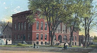
Waterville is a city in Kennebec County, Maine, United States, on the west bank of the Kennebec River. The city is home to Colby College and Thomas College. As of the 2020 census the population was 15,828. Along with Augusta, Waterville is one of the principal cities of the Augusta-Waterville, ME Micropolitan Statistical Area.

<span class="mw-page-title-main">Randolph, Maine</span> Town in the state of Maine, United States

Randolph is a town and a census-designated place (CDP) in Kennebec County, Maine, United States. The population was 1,743 at the 2020 census. The town was named for Randolph, Massachusetts. Randolph is included in the Augusta, Maine micropolitan New England City and Town Area.

<span class="mw-page-title-main">Winslow, Maine</span> Town in the state of Maine, United States

Winslow is a town and census-designated place in Kennebec County, Maine, United States, along the Kennebec River across from Waterville. The population was 7,948 at the 2020 census.

<span class="mw-page-title-main">Kennebunk (CDP), Maine</span> Census-designated place in Maine, United States

Kennebunk is a census-designated place (CDP) comprising the central village in the town of Kennebunk in York County, Maine, United States. The population was 5,214 at the 2010 census, out of a total town population of 10,798. It is part of the Portland–South Portland–Biddeford, Maine Metropolitan Statistical Area.

<span class="mw-page-title-main">Oakland, Maine</span> Town in the state of Maine, United States

Oakland is a town in Kennebec County in the U.S. state of Maine. The population was 6,230 at the 2020 census. Oakland is 4 miles (6 km) west of Waterville and approximately 18 miles (29 km) north of Augusta, the state capital. Waterville and Augusta are service centers for Oakland, and many Oakland residents commute to jobs in those areas.

<span class="mw-page-title-main">Farmington (CDP), Maine</span> Census-designated place in Maine, United States

Farmington is a census-designated place (CDP) comprising the center of the town of Farmington, which is the county seat of Franklin County in Maine, United States. The population of the CDP was 4,288 at the 2010 census, out of 7,760 people in the town as a whole. The University of Maine at Farmington is located within the CDP.

Wilton is a census-designated place (CDP) consisting of the main settlement within the town of Wilton in Franklin County, Maine, United States. The CDP population was 2,198 at the 2010 census, out of a total town population of 4,116.

<span class="mw-page-title-main">Clinton (CDP), Maine</span> Census-designated place in Maine, United States

Clinton is a census-designated place (CDP) and the primary village in the town of Clinton in Kennebec County, Maine, United States. The population was 1,419 at the 2010 census, out of 3,486 in the entire town of Clinton.

<span class="mw-page-title-main">Farmingdale (CDP), Maine</span> Census-designated place in Maine, United States

Farmingdale is a census-designated place (CDP) in the town of Farmingdale in Kennebec County, Maine, United States. The population was 1,970 at the 2010 census, out of 2,956 in the entire town.

<span class="mw-page-title-main">Winthrop (CDP), Maine</span> Census-designated place in Maine, United States

Winthrop is a census-designated place (CDP) comprising the primary settlement in the town of Winthrop in Kennebec County, Maine, United States. The population was 2,650 at the 2010 census, out of 6,092 in the town of Winthrop as a whole.

<span class="mw-page-title-main">Anson, Maine</span> Town in the state of Maine, United States

Anson is a town in Somerset County, Maine, United States. The population was 2,291 at the time of the 2020 census. It includes the villages of Anson and North Anson.

<span class="mw-page-title-main">Bingham, Maine</span> Town in the state of Maine, United States

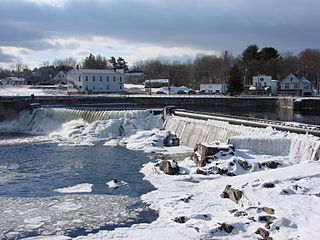
Bingham is a town in Somerset County, Maine, United States. The population was 866 at the 2020 census. Bingham is a historic town located beside the Kennebec River.

<span class="mw-page-title-main">Fairfield, Maine</span> Town in Maine, United States

Fairfield is a town in Somerset County, Maine, United States. The population was 6,484 at the 2020 census. The town includes Fairfield Center, Fairfield village and Hinckley, and borders the city of Waterville to the south. It is home to the Good Will-Hinckley School, Lawrence High School and Kennebec Valley Community College.

<span class="mw-page-title-main">Skowhegan (CDP), Maine</span> CDP in Maine, United States

Skowhegan is a census-designated place (CDP) in the town of Skowhegan in Somerset County, Maine, United States. The population was 6,404 at the 2020 census.

References

  1. "2020 U.S. Gazetteer Files". United States Census Bureau. Retrieved April 8, 2022.
  2. 1 2 "Geographic Identifiers: 2010 Census Summary File 1 (G001), Oakland CDP, Maine". American FactFinder. U.S. Census Bureau. Archived from the original on February 13, 2020. Retrieved March 11, 2019.
  3. "US Gazetteer files: 2010, 2000, and 1990". United States Census Bureau. February 12, 2011. Retrieved April 23, 2011.
  4. "Census of Population and Housing". Census.gov. Retrieved June 4, 2016.
  5. "U.S. Census website". United States Census Bureau . Retrieved January 31, 2008.